Area Overview for M21 9JL
Photos of M21 9JL
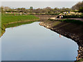

![River Mersey, looking downstream [north] in M21 9JL](https://images.propbar.co.uk/images/geograph/43/50/4350045_120.jpg)


Area Information
Living in M21 9JL means being part of a small, tightly knit residential cluster in England, home to 1,476 people. This postcode area is characterised by its compact layout, where daily life is shaped by proximity to local amenities and transport links. The community here is predominantly composed of adults aged 30–64, with a median age of 47, suggesting a mature, stable population. While the area is small, it offers practical access to shops, public transport, and nearby airports, making it suitable for those prioritising convenience. The housing stock is largely made up of flats, reflecting a mix of owner-occupied and rental properties. Residents benefit from excellent broadband connectivity, though crime rates are above average, which potential buyers should consider. For those seeking a quiet, manageable environment with accessible services, M21 9JL provides a straightforward, no-frills living experience.
- Area Type
- Postcode
- Area Size
- Not available
- Population
- 1476
- Population Density
- 7756 people/km²
The property market in M21 9JL is defined by a 50% home ownership rate, with flats making up the majority of housing stock. This suggests a balance between owner-occupied and rental properties, though the small size of the area means the market is limited in scope. Flats are likely to dominate due to the compact nature of the postcode cluster, which may appeal to buyers seeking low-maintenance living. However, the lack of larger homes or diverse property types could limit options for those prioritising space or specific housing needs. For buyers, the area’s proximity to transport and amenities may offset its modest size, but the limited range of property types means competition could be fierce for available listings.
House Prices in M21 9JL
No properties found in this postcode.
Energy Efficiency in M21 9JL
Daily life in M21 9JL is shaped by its proximity to a range of amenities. Residents have access to five retail outlets, including Co-op Chorlton and Tesco Chorlton, offering essential shopping. Transport hubs like Stretford Station and Chorlton Station provide easy access to nearby cities and suburbs, while rail stations such as Trafford Park Railway Station connect to broader networks. The area’s proximity to Manchester City Airport and other terminals makes travel straightforward. For leisure, the presence of multiple railway and metro stations suggests opportunities for commuting or weekend trips. While parks or recreational spaces are not explicitly listed, the area’s compact layout ensures most amenities are within a short walk or drive.
Amenities
Schools
The nearest school to M21 9JL is Oaklands Preparatory School, an independent institution. This type of school typically caters to younger students and may offer specialised curricula or smaller class sizes. However, the data does not provide Ofsted ratings or additional details about the school’s performance. The presence of an independent school suggests the area may attract families seeking alternative educational options, though the lack of state schools or further education institutions could be a consideration for some buyers.
| Rank | School | Type | Entry gender | Ages |
|---|
Explore more schools in this area
Go to Schools tabDemographics
The population of M21 9JL is 1,476, with a median age of 47 and the majority of residents falling within the 30–64 age range. This suggests a community of established professionals and families, rather than a younger or retired demographic. Home ownership stands at 50%, with flats being the predominant accommodation type. The predominant ethnic group is White, though no further diversity data is provided. The age profile indicates a stable, low-turnover population, which may influence local services and amenities. With no specific deprivation data available, the area’s quality of life appears to align with its modest scale and practical infrastructure.
Household Size
Accommodation Type
Tenure
Ethnic Group
Religion
Household Composition
Age
Household Deprivation
NS-SEC
Explore more demographic insights in this area
Go to Demographics tabPlanning
Planning Constraints
- Flood RiskPremium
- Ramsar Wetland SitesPremium
- Area of Outstanding Natural BeautyPremium
- Protected Nature ReservePremium
- Protected WoodlandPremium