Area Overview for M21 8BZ
Photos of M21 8BZ
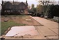

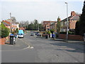


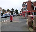
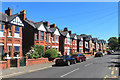
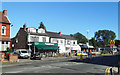
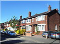
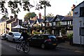
74 photos from this area
Area Information
Key information about the M21 8BZ including its size, population, and administrative classification.
- Area Type
- Postcode
- Area Size
- 8523 m²
- Population
- 1492
- Population Density
- 4370 people/km²
House Prices in M21 8BZ
31
Properties
£380,966
Average Sold Price
£57,500
Lowest Price
£725,000
Highest Price
Showing 31 properties
| Address | Type | Beds | Baths | Last Sale Price | Last Sale Date | |
|---|---|---|---|---|---|---|
| 37 Claude Road, Manchester, M21 8BZ | house | - | - | £375,000 | May 2024 | |
| 25 Claude Road, Manchester, M21 8BZ | Terraced | 3 | 1 | £470,000 | Mar 2024 | |
| 49 Claude Road, Manchester, M21 8BZ | Semi-detached | 3 | 2 | £645,000 | Feb 2024 | |
| 27 Claude Road, Manchester, M21 8BZ | Terraced | 3 | 2 | £400,000 | Jun 2023 | |
| 51 Claude Road, Manchester, M21 8BZ | house | - | - | £725,000 | Feb 2022 | |
| 39 Claude Road, Manchester, M21 8BZ | house | - | - | £450,000 | Jan 2022 | |
| 45 Claude Road, Manchester, M21 8BZ | Semi-detached | 3 | 1 | £460,000 | Jul 2019 | |
| 55 Claude Road, Manchester, M21 8BZ | house | - | - | £537,500 | Mar 2018 | |
| 59 Claude Road, Manchester, M21 8BZ | house | - | - | £533,000 | Dec 2017 | |
| 41 Claude Road, Manchester, M21 8BZ | Terraced | 4 | - | £405,000 | Oct 2016 |
Page 1 of 4
Energy Efficiency in M21 8BZ
Amenities
Schools
| Rank | School | Type | Entry gender | Ages |
|---|
Explore more schools in this area
Go to Schools tabDemographics
Household Size
One person
most common
Accommodation Type
Houses
most common
Tenure
48
majority
Ethnic Group
White
most common
Religion
N/A
most common
Household Composition
N/A
most common
Age
47
median
Adults (30-64 years)
most common
Household Deprivation
N/A
with no deprivation
NS-SEC
44
in Lower managerial occupations
Explore more demographic insights in this area
Go to Demographics tabPlanning
Planning Constraints
- Flood RiskPremium
- Ramsar Wetland SitesPremium
- Area of Outstanding Natural BeautyPremium
- Protected Nature ReservePremium
- Protected WoodlandPremium