Area Overview for M21 3DW
Photos of M21 3DW


Area Information
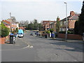
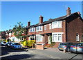
Living in M21 3DW offers a snapshot of a compact, residential community in England’s northern regions. With a population of 1,427, this postcode area is small but functional, catering to a mix of daily needs and connectivity. The area’s character is defined by its proximity to transport hubs and retail centres, making it practical for commuters and those who value accessibility. While it lacks the density of larger urban areas, it provides a quieter alternative with a focus on essential services. The demographic profile suggests a mature population, with the median age at 47 and the majority of residents falling within the 30–64 age range. This hints at a community rooted in stability, with many residents likely established in their careers and family life. Daily life here balances routine with the convenience of nearby amenities, from supermarkets to railway stations. The absence of significant natural constraints means the area is free from planning restrictions that might complicate development or living. However, the high crime risk score—0 out of 100—demands attention, as it indicates safety is a pressing concern for residents. For those prioritising practicality over scenic landscapes, M21 3DW offers a straightforward, no-frills living experience.
- Area Type
- Postcode
- Area Size
- Not available
- Population
- 1427
- Population Density
- 9364 people/km²
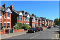
The property market in M21 3DW is characterised by a 48% home ownership rate, with houses forming the predominant accommodation type. This suggests a market skewed towards owner-occupation rather than rental properties, though the remaining 52% of residents likely rely on private rentals. The presence of houses rather than flats or apartments may indicate a preference for larger, more traditional living spaces, which could be attractive to families or those seeking greater independence. However, the small population of 1,427 implies a limited inventory of properties, meaning buyers may face competition for available homes. The area’s compact size also means the immediate surroundings are critical for property seekers, as nearby areas may offer more options. For those prioritising ownership, the market may provide stability, but the lack of data on property prices or trends means potential buyers must conduct further research. The housing stock’s focus on single-family homes may also limit options for those seeking smaller or more modern properties.
House Prices in M21 3DW
No properties found in this postcode.
Energy Efficiency in M21 3DW
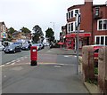
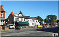
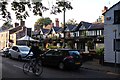
Residents of M21 3DW have access to a range of essential amenities within practical reach. Retail options include major supermarkets such as Morrisons Whalley, Co-op Chorlton, and Tesco Chorlton, ensuring daily shopping needs are met. The area’s transport links, including Chorlton Station and Firswood Station, provide easy access to nearby leisure and employment hubs. For those interested in sports or culture, proximity to Trafford Park Railway Station and Manchester United FC Railway Station offers connections to larger venues. The nearby airports—City Airport Manchester, Terminal Two Access, and Terminal One Access—cater to frequent flyers. While the area lacks dedicated parks or recreational spaces, its transport links allow quick access to green spaces in surrounding regions. The presence of multiple railway stations and retail centres creates a functional lifestyle, where daily routines are supported by nearby services. However, the absence of named parks or cultural institutions within the postcode itself means residents must venture slightly beyond M21 3DW for leisure activities.
Amenities
Schools
| Rank | School | Type | Entry gender | Ages |
|---|
Explore more schools in this area
Go to Schools tabDemographics
The community in M21 3DW is predominantly composed of adults aged 30–64, with a median age of 47. This suggests a population largely in their prime working years, likely settled in careers and family life. Home ownership stands at 48%, indicating that nearly half of residents own their properties, while the remaining 52% are likely renters. The accommodation type is primarily houses, which is unusual for areas with higher apartment or flat density. This housing stock may appeal to those seeking more space or privacy. The predominant ethnic group is White, with no data provided on other demographics. The absence of specific figures on diversity means the area’s cultural composition remains less defined. The age profile and ownership rates suggest a stable, middle-aged population with established routines. However, the lack of data on deprivation or income levels means it is unclear how economic factors influence quality of life. The community appears to prioritise practical living over transient or high-turnover housing models.
Household Size
Accommodation Type
Tenure
Ethnic Group
Religion
Household Composition
Age
Household Deprivation
NS-SEC
Explore more demographic insights in this area
Go to Demographics tabPlanning
Planning Constraints
- Flood RiskPremium
- Ramsar Wetland SitesPremium
- Area of Outstanding Natural BeautyPremium
- Protected Nature ReservePremium
- Protected WoodlandPremium