Area Overview for M21 3AA
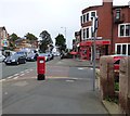
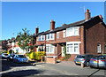
Photos of M21 3AA


Area Information
M21 3AA is a small, tightly knit residential cluster in England, home to 1,427 people. Its compact size fosters a quiet, community-oriented atmosphere, with homes predominantly occupied by adults aged 30–64. The area’s proximity to major transport hubs and retail centres makes it practical for daily life, while its low flood risk and absence of environmental constraints offer reassurance for long-term living. Residents benefit from easy access to nearby amenities, including multiple supermarkets, train stations, and airports, which support both local needs and regional connectivity. The area’s character is defined by its balance of convenience and tranquillity, appealing to those seeking a stable, well-served environment without the bustle of larger urban centres. With a median age of 47, the community leans towards middle-aged professionals and families, creating a steady, predictable rhythm to local life. While the area is small, its strategic location near key infrastructure ensures it is not isolated, offering residents the best of both suburban comfort and urban accessibility.
- Area Type
- Postcode
- Area Size
- Not available
- Population
- 1427
- Population Density
- 9364 people/km²
In M21 3AA, 48% of properties are owner-occupied, with houses being the predominant accommodation type. This suggests a market skewed towards private ownership rather than rentals, though the exact proportion of rental properties is not specified. The small size of the area means housing stock is likely limited, with homes concentrated in a compact cluster. The absence of high-rise or commercial developments indicates a focus on residential living, possibly with older or traditional housing stock. For buyers, this means a niche market with limited options, but the proximity to transport links and amenities may offset the area’s small size. The high home ownership rate could imply stable property values, though without price data, this remains speculative. Prospective buyers should consider the area’s constraints—its small footprint and lack of expansion potential—when evaluating long-term investment. The mix of owner-occupied and rental properties also suggests a balance between established residents and those seeking rental opportunities, though the latter’s presence is not quantified.
House Prices in M21 3AA
No properties found in this postcode.
Energy Efficiency in M21 3AA
Living in M21 3AA offers a blend of convenience and accessibility, with retail options such as Morrisons Whalley, Co-op Chorlton, and Tesco Chorlton within walking or short driving distance. These stores provide essentials, groceries, and services, reducing the need for long trips. The area’s transport links are a key feature, with five train stations—including Chorlton Station and St Werburgh’s Road—offering connections to Manchester’s broader rail network. Nearby airports, including Manchester City Airport, ensure easy travel for both leisure and business. For commuters, the proximity to Trafford Park Railway Station and Humphrey Park Railway Station adds flexibility. The presence of Chorlton Street Coach Station further enhances local mobility. While the area lacks major parks or leisure facilities, its strategic location near urban centres means residents can access larger recreational spaces nearby. The mix of retail, transport, and regional connectivity creates a lifestyle that balances local convenience with broader opportunities, ideal for those prioritising practicality and accessibility.
Amenities
Schools
| Rank | School | Type | Entry gender | Ages |
|---|
Explore more schools in this area
Go to Schools tabDemographics
The population of M21 3AA is 1,427, with a median age of 47, indicating a mature, stable community. The majority of residents fall within the 30–64 age range, suggesting a mix of established professionals and families. Home ownership rates stand at 48%, meaning nearly half of properties are owner-occupied, while the remaining 52% are likely rented. The area is predominantly inhabited by White residents, reflecting a homogenous demographic profile. This age group and ownership structure imply a focus on long-term residency rather than transient populations. The absence of specific data on deprivation levels means the quality of life can be inferred from the area’s amenities and safety assessments. With no protected natural sites or planning constraints, the community’s lifestyle is shaped by accessible services and transport rather than environmental restrictions. The demographic profile suggests a need for services tailored to middle-aged adults, such as healthcare and retirement planning, though such specifics are not detailed in the data.
Household Size
Accommodation Type
Tenure
Ethnic Group
Religion
Household Composition
Age
Household Deprivation
NS-SEC
Explore more demographic insights in this area
Go to Demographics tabPlanning
Planning Constraints
- Flood RiskPremium
- Ramsar Wetland SitesPremium
- Area of Outstanding Natural BeautyPremium
- Protected Nature ReservePremium
- Protected WoodlandPremium