Area Overview for M20 2RR
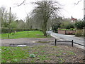
Photos of M20 2RR


Area Information
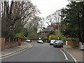
Living in M20 2RR offers a quiet, residential experience in a small cluster of homes. With a population of 1,369, this area is compact but well-served by nearby amenities. The community is predominantly composed of adults aged 30–64, many of whom own their homes. Daily life here is characterised by proximity to retail, transport, and leisure options. The area’s small size means it is likely to feel close-knit, though it remains distinct from larger urban centres. Residents benefit from good digital connectivity and multiple transport links, including rail stations and bus routes. While the area lacks natural beauty designations, its practical advantages—such as access to major roads and airports—make it appealing for those prioritising convenience. However, the high crime risk is a notable concern, requiring vigilance. For buyers seeking a stable, owner-occupied environment with accessible services, M20 2RR could be a viable option, though its limited size means choices are constrained to the immediate vicinity.
- Area Type
- Postcode
- Area Size
- Not available
- Population
- 1369
- Population Density
- 1837 people/km²
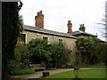
The property market in M20 2RR is dominated by owner-occupied homes, with 82% of residents living in properties they own. This contrasts with areas where rental markets are more prominent, suggesting a community of long-term residents rather than transient tenants. The accommodation type is primarily houses, which may appeal to families or those seeking more space than flats. Given the area’s small size, the housing stock is likely limited to the immediate vicinity, meaning buyers must consider nearby areas for additional options. The high home ownership rate indicates a stable market with potentially strong equity retention, though the lack of data on property prices or recent transactions means it is unclear whether this is a buyer’s or seller’s market. For those seeking a home in a residential setting with established neighbours, M20 2RR offers a straightforward, owner-focused environment.
House Prices in M20 2RR
No properties found in this postcode.
Energy Efficiency in M20 2RR
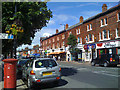
Residents of M20 2RR have access to a range of amenities within practical reach. Retail options include Co-op Didsbury, Tesco East, and M&S Didsbury SF, providing everyday shopping needs. The nearby metro areas of Didsbury Village, East Didsbury, and West Didsbury offer a mix of dining, leisure, and community spaces. Rail stations such as East Didsbury and Burnage connect to broader networks, while the proximity to airports ensures easy travel. Though the area lacks detailed information on parks or recreational facilities, the presence of multiple transport hubs suggests a focus on accessibility over green spaces. The combination of retail, transport, and airport access creates a convenient lifestyle, particularly for those prioritising ease of movement. However, the absence of named parks or leisure venues means the area’s recreational offerings remain unspecified.
Amenities
Schools
| Rank | School | Type | Entry gender | Ages |
|---|
Explore more schools in this area
Go to Schools tabDemographics
The community in M20 2RR is largely composed of adults aged 30–64, with a median age of 47. This suggests a mature, established population, many of whom are likely to be in their prime working years. Home ownership is high, with 82% of residents owning their properties, indicating a stable housing market. The predominant accommodation type is houses, which aligns with the area’s residential character. The predominant ethnic group is White, reflecting a relatively homogenous demographic. While no specific data on deprivation is provided, the high home ownership rate and age profile suggest a community with moderate economic stability. However, the absence of detailed diversity metrics means the full scope of the area’s social composition remains unclear. The age range also implies that family-oriented services and amenities may be in demand, though this is not explicitly confirmed by the data.
Household Size
Accommodation Type
Tenure
Ethnic Group
Religion
Household Composition
Age
Household Deprivation
NS-SEC
Explore more demographic insights in this area
Go to Demographics tabPlanning
Planning Constraints
- Flood RiskPremium
- Ramsar Wetland SitesPremium
- Area of Outstanding Natural BeautyPremium
- Protected Nature ReservePremium
- Protected WoodlandPremium