Area Overview for M1 3HX
Photos of M1 3HX


Area Information
M1 3HX is a compact residential postcode in England, home to 1851 people spread across a small cluster of properties. The area is defined by its proximity to urban infrastructure, with easy access to public transport and retail hubs. Daily life here is shaped by its mix of young adults and older residents, creating a dynamic but tightly knit community. While the population is modest, the area benefits from being near key transport links, including multiple railway stations and metro stops. The absence of natural constraints like protected woodlands or wetlands means development is unencumbered, though flood risk remains negligible. For those seeking a balance between city convenience and manageable size, M1 3HX offers a practical base, though its small footprint means amenities are concentrated within a short walk or journey. The area’s character is defined by its accessibility, with residents able to reach major destinations swiftly.
- Area Type
- Postcode
- Area Size
- Not available
- Population
- 1851
- Population Density
- 5927 people/km²
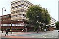
The property market in M1 3HX is characterised by a high proportion of rental properties, with only 21% of residents owning their homes. The accommodation type is almost entirely flats, which suggests a focus on compact, urban living. This configuration is typical of areas near transport hubs, where space is limited and demand for proximity to services is strong. For buyers, the small area’s housing stock is likely to be limited, with few opportunities for owner-occupation. The dominance of flats may also mean limited scope for property customization or long-term equity growth. Those considering purchase should factor in the area’s rental-centric nature, which may influence both availability and pricing.
House Prices in M1 3HX
No properties found in this postcode.
Energy Efficiency in M1 3HX
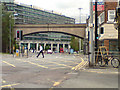
Living in M1 3HX provides access to a range of practical amenities within walking or short transit distance. Retail options include Spar, Lidl City Tower, and Tesco City, offering everyday essentials. The area’s transport links connect residents to leisure spots like Piccadilly Gardens and St Peter’s Square, which are popular for relaxation or events. The presence of multiple railway stations, such as Deansgate and Salford Central, enhances mobility, while the metro system provides swift access to surrounding areas. This combination of retail, transport, and green spaces creates a convenient, urban lifestyle, though the area’s small size means amenities are concentrated rather than spread out.
Amenities
Schools
| Rank | School | Type | Entry gender | Ages |
|---|
Explore more schools in this area
Go to Schools tabDemographics
The population of M1 3HX has a median age of 47, but the most common age group is young adults aged 15–29, indicating a mix of older and younger residents. Home ownership is low, with only 21% of households owning their properties, suggesting a rental-dominated market. The accommodation type is predominantly flats, reflecting a preference for urban living or shared spaces. The predominant ethnic group is White, though no specific diversity metrics are provided. This demographic profile implies a community that may include students, young professionals, or those seeking affordable housing. The low home ownership rate could indicate economic pressures or a transient population, but it also means the area may cater to renters prioritising location over long-term investment.
Household Size
Accommodation Type
Tenure
Ethnic Group
Religion
Household Composition
Age
Household Deprivation
NS-SEC
Explore more demographic insights in this area
Go to Demographics tabPlanning
Planning Constraints
- Flood RiskPremium
- Ramsar Wetland SitesPremium
- Area of Outstanding Natural BeautyPremium
- Protected Nature ReservePremium
- Protected WoodlandPremium