Area Overview for Langho
Photos of Langho


Area Information
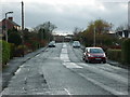
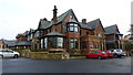
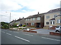
Living in Langho offers a distinct pace of life within a built-up area that spans 76.6 hectares. While fewer data points define the modern счёт compared to larger cities, the character of Langho is defined by its established footprint in England. You will find that daily life here revolves around a close-knit community where the boundaries between home and local amenities are practical and well-defined. The area functions as a traditional settlement where residents rely on established connections rather than the constant flux of a metropolitan centre. You can explore the neighbourhood knowing that the physical scale is manageable, allowing for easy access to local services without the congestion of major urban centres. This built-up area provides a setting where the density allows for community interaction while maintaining a residential feel. Whether you are considering homes in Langho for retirement or moving to a more established village environment, the layout supports a grounded, quieter existence. The area's size ensures that neighbours remain reachable, fostering an environment where local knowledge is passed down through generations. You benefit from a living situation where the distance to daily necessities is short and the atmosphere remains unchanged by rapid development.
- Area Type
- Built Up Area 250
- Area Size
- 76.6 hectares
- Population
- Not available
- Population Density
- Not available
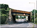
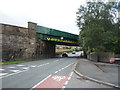
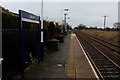
Daily life in Langho is supported by a small cluster of amenities that are within practical reach. You can shop locally at a Spar, Co-op Wilpshire, and another Spar, ensuring your essential grocery needs are met without travelling far. The availability of five retail outlets indicates a neighbourhood where shopping trips are short and convenient. There are also five railway stations nearby, offering more than just transport but also often serving as local meeting points or hubs. Langho Railway Station, Ramsgreave & Wilpshire Railway Station, and Whalley Railway Station provide immediate access to broader regions. While there is no data on parks, leisure centres, or dining options in the provided records, the presence of these shops and stations forms the core of your lifestyle infrastructure. The character of the area revolves around these accessible services, giving you the convenience of a village where everything is walkable or a short drive away. You do not need to travel to larger towns for basic supplies, as the local high street options in Langho cover the fundamentals well.
Amenities
Schools
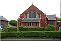
Families in Langho have access to two primary schools, both holding a 'good' Ofsted rating. Langho and Billington St Leonards Church of England Primary School is one of the key educational institutions serving the neighbourhood. You will also find St Mary's Roman Catholic Primary School, Langho, which stands as another recognised option for local children. Having two separate primary schools covered by their respective denominations provides families with choice regarding religious education and school culture. The fact that both institutions hold a 'good' rating ensures a baseline of educational quality regardless of which specific school you choose for your child. This mix of a Church of England and a Roman Catholic school indicates a supportive environment for various family backgrounds within Langho. While secondary education details are not listed in the immediate proximity data, the presence of these well-rated primary schools suggests a focused approach to early education in the area. Parents moving here can rely on these specific, named venues for their children's early schooling needs.
| Rank | School | Type | Entry gender | Ages |
|---|
Explore more schools in this area
Go to Schools tabDemographics
The community in Langho is defined by an older population, with a median age of 70 years. This demographic profile indicates that the area serves as a significant retirement destination for many families. The most common age range encompasses the total population, reflecting a broad but predominantly senior household composition. You will discover that 90% of residents own their homes, a figure that is exceptionally high compared to national averages. This high rate of home ownership suggests that the properties in Langho are widely valued by current and previous successive generations. The accommodation types across Langho reflect this ownership pattern, with very few rental properties dominating the streets. Diversity data is not explicitly detailed in the available records, but the stability of home ownership shapes a consistent community culture. This demographic structure means you are purchasing into an area where the footprints of previous owners have been maintained through the years. The low proportion of younger households suggests that moving to Langho often comes with specific lifestyle expectations regarding space, quiet, and proximity to established services.
Household Size
Accommodation Type
Tenure
Ethnic Group
Religion
Household Composition
Age
Household Deprivation
NS-SEC
Explore more demographic insights in this area
Go to Demographics tabPlanning
Planning Constraints
- Crime RiskPremium