Area Overview for LA5 0HH
Photos of LA5 0HH
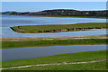
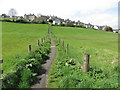
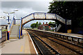
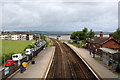

67 photos from this area
Area Information
Key information about the LA5 0HH including its size, population, and administrative classification.
- Area Type
- Postcode
- Area Size
- 5.6 hectares
- Population
- 2502
- Population Density
- 271 people/km²
House Prices in LA5 0HH
17
Properties
£205,429
Average Sold Price
£46,000
Lowest Price
£475,000
Highest Price
Showing 17 properties
| Address | Type | Beds | Baths | Last Sale Price | Last Sale Date | |
|---|---|---|---|---|---|---|
| Friesian Way, 12 Black Dyke Road, Arnside, LA5 0HH | house | - | - | £475,000 | Feb 2024 | |
| Sunnyside, 9 Black Dyke Road, Arnside, LA5 0HH | Bungalow | 2 | - | £390,000 | Feb 2023 | |
| Heatherdene, 7 Black Dyke Road, Arnside, LA5 0HH | house | - | - | £250,000 | Nov 2022 | |
| High Bank, 16 Black Dyke Road, Arnside, LA5 0HH | Bungalow | - | - | £275,000 | Mar 2021 | |
| Meadow Bank, 15 Black Dyke Road, Arnside, LA5 0HH | house | - | - | £280,000 | Mar 2021 | |
| 10 Black Dyke Road, Arnside, LA5 0HH | Bungalow | 2 | 1 | £200,000 | Jul 2019 | |
| Glynn Dene, 3 Black Dyke Road, Arnside, LA5 0HH | Bungalow | - | - | £185,000 | Sep 2014 | |
| Pa Mor An, 8 Black Dyke Road, Arnside, LA5 0HH | Bungalow | - | - | £150,000 | Sep 2014 | |
| Loen, 14 Black Dyke Road, Arnside, LA5 0HH | Bungalow | 3 | - | £240,000 | May 2012 | |
| Westmount, 5 Black Dyke Road, Arnside, LA5 0HH | Detached | - | - | £112,500 | Dec 2002 |
Page 1 of 2
Energy Efficiency in LA5 0HH
Amenities
Schools
| Rank | School | Type | Entry gender | Ages |
|---|
Explore more schools in this area
Go to Schools tabDemographics
Household Size
Two person
most common
Accommodation Type
Houses
most common
Tenure
84
majority
Ethnic Group
White
most common
Religion
N/A
most common
Household Composition
N/A
most common
Age
47
median
Elderly (65+ years)
most common
Household Deprivation
N/A
with no deprivation
NS-SEC
46
in Lower managerial occupations
Explore more demographic insights in this area
Go to Demographics tabPlanning
Planning Constraints
- Flood RiskPremium
- Ramsar Wetland SitesPremium
- Area of Outstanding Natural BeautyPremium
- Protected Nature ReservePremium
- Protected WoodlandPremium