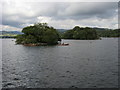
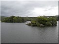
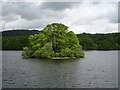
Area Overview for LA23 3DL
Photos of LA23 3DL


Area Information
Living in LA23 3DL means being part of a small, tightly knit residential cluster in England, covering just 11.7 hectares. With a population of 1,764 people, the area has a moderate density of 326 people per square kilometre, creating a balance between privacy and community. This postcode is characterised by a mix of houses, reflecting its predominantly owner-occupied nature, with 59% of homes owned by residents. The median age of 47 suggests a stable population of adults aged 30–64, many of whom may be long-term residents or professionals working in nearby towns. Daily life here is shaped by proximity to local amenities, including shops, ferries, and a rail station, while the surrounding landscape offers a quiet, residential atmosphere. The area’s compact size means residents are likely to know their neighbours, and its location near natural waterways adds to its charm. However, prospective buyers should consider the area’s safety assessments, which highlight both flood risk and crime concerns, as these factors influence long-term livability.
- Area Type
- Postcode
- Area Size
- 11.7 hectares
- Population
- 1764
- Population Density
- 326 people/km²
The property market in LA23 3DL is defined by its high home ownership rate of 59%, with houses being the primary accommodation type. This suggests a largely owner-occupied area rather than a rental market, which may limit availability for buyers seeking to move into the area. The compact size of the postcode—just 11.7 hectares—means the housing stock is limited, and properties are likely to be spread across a small number of streets. The predominance of houses over flats indicates a more traditional, low-density residential environment, which may appeal to those seeking space and privacy. However, the small size of the area means that buyers should consider nearby regions for a broader range of options. The market is likely to be competitive, with properties holding value due to their scarcity. Prospective buyers should also weigh the area’s safety assessments, which include high flood risk and crime concerns, against the benefits of a close-knit community and accessible amenities.
House Prices in LA23 3DL
Showing 1 properties
| Address | Type | Beds | Baths | Last Sale Price | Last Sale Date | |
|---|---|---|---|---|---|---|
| Park Wardens Caravan, Fallbarrow Caravan Park, Rayrigg Road, Windermere, LA23 3DL | assembly_leisure | - | - | - | - |
Energy Efficiency in LA23 3DL
Residents of LA23 3DL have access to a range of local amenities within practical reach. The area includes five retail outlets, such as Spar Bowness, Tesco Bowness, and Co-op Bowness, ensuring basic shopping needs are met. Ferry services, including Windermere Steam Boat Museum Ferry Terminal and Bowness Ferry Nab, provide convenient access to Windermere, which may be a focal point for leisure activities, boating, or scenic walks. The nearby Staveley Railway Station offers rail connections to surrounding areas, enhancing mobility for commuters. While the area lacks dedicated parks or green spaces within its boundaries, the proximity to Windermere suggests opportunities for outdoor recreation. The combination of retail, transport, and water-based connectivity creates a lifestyle that balances convenience with access to natural surroundings. However, the absence of local schools or major leisure facilities means residents may need to travel further for certain amenities.
Amenities
Schools
The nearest school to LA23 3DL is Lindeth College of Further Education, which is a special school. This indicates that the area does not have primary or secondary schools within its immediate boundaries, which may require families to look further afield for education. The presence of a special school suggests that the community may cater to students with specific learning needs, but it does not provide a full range of educational options for younger children. Families with children may need to rely on nearby towns or schools outside the postcode for primary and secondary education. The absence of local schools could be a drawback for some buyers, particularly those prioritising convenience. However, the area’s proximity to transport links, including a rail station and ferry terminals, may mitigate this by facilitating access to schools in surrounding areas.
| Rank | School | Type | Entry gender | Ages |
|---|
Explore more schools in this area
Go to Schools tabDemographics
The community in LA23 3DL is predominantly composed of adults aged 30–64, with a median age of 47. This suggests a mature population, likely including families, professionals, and retirees. Home ownership is strong, with 59% of residents owning their homes, compared to 41% renting. The area is largely composed of houses, not flats, indicating a suburban or semi-rural character. The predominant ethnic group is White, reflecting a homogenous demographic profile. With a population density of 326 people per square kilometre, the area is neither densely packed nor overly spread out, offering a balance between space and accessibility. The age profile suggests a stable community with fewer young children or elderly residents, which may influence local services and amenities. This demographic structure could mean fewer childcare facilities but a greater focus on adult-oriented services, such as retail and transport links.
Household Size
Accommodation Type
Tenure
Ethnic Group
Religion
Household Composition
Age
Household Deprivation
NS-SEC
Explore more demographic insights in this area
Go to Demographics tabPlanning
Planning Constraints
- Flood RiskPremium
- Ramsar Wetland SitesPremium
- Area of Outstanding Natural BeautyPremium
- Protected Nature ReservePremium
- Protected WoodlandPremium