Area Overview for LA20 6JJ
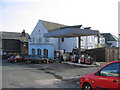
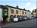
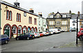
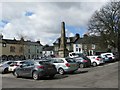
Photos of LA20 6JJ


Area Information
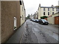
Living in LA20 6JJ means being part of a small, tightly knit residential cluster in England, where the population of 1,031 people spreads across 15 residents per square kilometre. This low density suggests spacious living, with homes likely set apart from one another. The area’s character is defined by its quiet, suburban feel, with a strong presence of owner-occupied houses. Daily life here is shaped by proximity to local amenities, including rail stations, ferry landings, and small retail outlets. The community is predominantly composed of adults aged 30–64, reflecting a mature demographic with established roots. While the area lacks large-scale urban infrastructure, its compact size fosters a sense of familiarity. Residents benefit from low crime rates and minimal environmental risks, making it a stable place to live. The mix of primary schools and a special needs institution ensures families have options for education, while the surrounding countryside offers a peaceful backdrop. For those seeking a quieter lifestyle with easy access to transport and basic services, LA20 6JJ provides a balanced environment.
- Area Type
- Postcode
- Area Size
- Not available
- Population
- 1031
- Population Density
- 15 people/km²
The property market in LA20 6JJ is characterised by high home ownership (78%) and a predominance of houses over flats or apartments. This suggests a market skewed towards owner-occupied properties, with limited rental stock. The small size of the area means the housing stock is likely limited, with few new developments. Buyers considering this postcode should expect a focus on family homes, given the demographic of mature adults and the presence of schools. The low population density also implies larger plots of land, which may appeal to those seeking spacious living. However, the small size of the area means that property availability is constrained, and buyers may need to look beyond LA20 6JJ for more options. The market is likely to be stable, with little pressure from speculative investment, given the low population and moderate demand.
House Prices in LA20 6JJ
No properties found in this postcode.
Energy Efficiency in LA20 6JJ
The lifestyle in LA20 6JJ is shaped by its proximity to practical amenities, including rail stations, ferry landings, and small retail outlets. Residents can access shops like Tesco Millom and Co-op Askam for daily needs, while the three nearby ferry landings provide opportunities for water-based travel or leisure. The rail network, with stations such as Foxfield and Green Road, connects the area to broader transport routes, facilitating commutes to nearby towns. Though the area lacks large parks or entertainment venues, the low population density and surrounding countryside suggest outdoor space is available. The mix of retail and transport options supports a self-sufficient lifestyle, with minimal need to travel far for essentials. The presence of schools and low crime rates further enhances the area’s appeal for families seeking a quiet, functional environment.
Amenities
Schools
Residents of LA20 6JJ have access to a range of educational institutions, including Broughton CofE Primary and Nursery School, which holds a ‘good’ Ofsted rating, and Ulpha CofE School, a primary institution. For families with children requiring specialist support, Broughton Tower Residential School, a special needs institution, is also nearby. This mix of school types ensures a variety of options for parents, from mainstream primary education to tailored support for students with additional needs. The presence of two primary schools within the area suggests a focus on early education, while the special school caters to specific requirements. Families seeking a comprehensive educational environment may find this combination beneficial, though the absence of secondary schools means proximity to larger towns or cities would be necessary for older children.
| Rank | School | Type | Entry gender | Ages |
|---|
Explore more schools in this area
Go to Schools tabDemographics
The population of LA20 6JJ is 1,031, with a median age of 47 and the majority of residents falling into the 30–64 age range. This suggests a community of established adults, many of whom are likely to be homeowners. Home ownership here is high, with 78% of properties owned by residents, compared to the UK average of around 65%. The accommodation type is predominantly houses, indicating a lack of high-density housing such as flats. The predominant ethnic group is White, though no further breakdown of diversity is provided. The low population density of 15 people per square kilometre implies a spread-out, suburban layout rather than a densely packed urban area. While no specific data on deprivation is available, the high home ownership and low crime rates suggest a relatively stable socioeconomic profile. This demographic profile supports a community focused on long-term residency and family-oriented living.
Household Size
Accommodation Type
Tenure
Ethnic Group
Religion
Household Composition
Age
Household Deprivation
NS-SEC
Explore more demographic insights in this area
Go to Demographics tabPlanning
Planning Constraints
- Flood RiskPremium
- Ramsar Wetland SitesPremium
- Area of Outstanding Natural BeautyPremium
- Protected Nature ReservePremium
- Protected WoodlandPremium