Area Overview for LA17 7UN
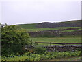
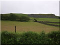
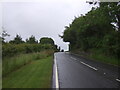
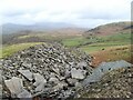
Photos of LA17 7UN


Area Information
Living in LA17 7UN offers a compact, low-density residential experience in a small cluster of homes. The area spans 2.2 km², with just 1,226 residents spread across 31 people per square kilometre, creating a quiet, uncluttered environment. This is a community where familiarity is common, with many residents likely knowing their neighbours. The area’s small size means amenities are within practical reach, including multiple railway stations, retail outlets, and ferry landings. Daily life here is defined by proximity to transport links and a mix of local services. While the population is modest, the area’s infrastructure supports both practical needs and leisure. The presence of Burlington CofE School, rated good by Ofsted, adds to the appeal for families. LA17 7UN is not a place for those seeking urban density; instead, it suits those prioritising space, safety, and a slower pace of life. The low crime risk and absence of environmental constraints make it a stable choice for homebuyers seeking a tranquil, well-connected small community.
- Area Type
- Postcode
- Area Size
- 2.2 km²
- Population
- 1226
- Population Density
- 31 people/km²
LA17 7UN is predominantly an owner-occupied area, with 82% of properties in private hands. The housing stock consists mostly of houses, reflecting a preference for detached or semi-detached homes over flats or apartments. This composition suggests a market where properties are likely to be larger, with gardens or outdoor space, appealing to those prioritising space and privacy. The small size of the area means the housing stock is limited, making it a niche market for buyers seeking a quiet, low-density environment. With high home ownership, the area is less likely to have a significant rental sector, reducing competition from tenants. For prospective buyers, this implies a stable market with properties that may appreciate in value due to their scarcity. However, the limited number of homes also means opportunities for purchase are restricted, requiring buyers to act decisively. The predominance of houses also means the area is unlikely to attract those seeking affordable, high-density housing options.
House Prices in LA17 7UN
Showing 1 properties
| Address | Type | Beds | Baths | Last Sale Price | Last Sale Date | |
|---|---|---|---|---|---|---|
| Burlington Slate, Cavendish House, Kirkby In Furness, Kirkby In Furness, LA17 7UN | office_workshop | - | - | - | - |
Energy Efficiency in LA17 7UN
Residents of LA17 7UN have access to a range of amenities within practical reach, including five retail outlets such as Morrisons Daily and Co-op Market, which cater to daily shopping needs. The area’s proximity to three ferry landings, like Sunny Bank Ferry Landing, offers opportunities for water-based leisure and travel. Five railway stations, including Green Road Railway Station, provide easy access to regional transport networks, facilitating both work and social travel. The presence of these amenities contributes to a convenient, self-contained lifestyle, reducing the need for long commutes. The mix of retail, transport, and ferry options suggests a community that balances practicality with accessibility. For those who enjoy outdoor activities, the ferry landings may provide access to nearby natural areas, while the railway stations connect to broader destinations. This combination of services and transport links ensures that daily life in LA17 7UN is both functional and varied.
Amenities
Schools
The nearest school to LA17 7UN is Burlington CofE School, a primary school with a good Ofsted rating. This provides a reliable educational option for young families in the area. The presence of a primary school within reach reduces the need for long commutes to secondary education, though no secondary schools are listed in the data. The school’s good rating indicates a focus on quality teaching and facilities, which is a key consideration for parents. The absence of other schools nearby means families may need to travel for secondary education, but the proximity of primary schooling supports early years development. For buyers, the availability of a well-regarded primary school adds to the area’s appeal, particularly for those prioritising family-friendly amenities. The school’s rating also suggests a community that values education, potentially contributing to a stable, cohesive local environment.
| Rank | School | Type | Entry gender | Ages |
|---|
Explore more schools in this area
Go to Schools tabDemographics
The population of LA17 7UN is predominantly adults aged 30-64, with a median age of 47. This suggests a mature, established community where most residents are in their prime working or retirement years. Home ownership is high at 82%, indicating a stable, long-term resident base. The area is composed mostly of houses, reflecting a preference for single-family living rather than flats or apartments. The predominant ethnic group is White, which aligns with broader demographic trends in the region. The low population density of 31 people per km² means the area avoids the congestion of larger towns. This profile suggests a community focused on comfort and permanence, with limited diversity in household types. For buyers, this implies a market where properties are likely to be well-maintained and held by owners with long-term plans. The demographic makeup also means local services cater to a specific age range, with schools and amenities tailored to families and older adults.
Household Size
Accommodation Type
Tenure
Ethnic Group
Religion
Household Composition
Age
Household Deprivation
NS-SEC
Explore more demographic insights in this area
Go to Demographics tabPlanning
Planning Constraints
- Flood RiskPremium
- Ramsar Wetland SitesPremium
- Area of Outstanding Natural BeautyPremium
- Protected Nature ReservePremium
- Protected WoodlandPremium