Area Overview for LA14 5SL
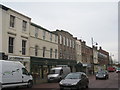
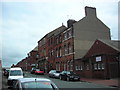
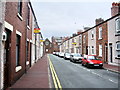
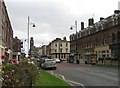
Photos of LA14 5SL


Area Information
Living in LA14 5SL offers a distinct residential experience within a compact 1.2-hectare cluster. You will find a small, defined community of 1,308 residents, creating an intimate neighbourhood feel. The area is situated in England and serves as a specific residential hub rather than a sprawling district. Despite the small footprint, the population density is extremely high at 106,988 people per square kilometre. This concentration means neighbours are close by, fostering immediate local connections. The setting is purely residential, distinct from commercial or industrial zones. Daily life here is characterised by a focus on housing within a tight-knit geographical boundary. This postcode covers a small group of residences that form the core of the local community. You are living in a defined area where the community size remains constant. The location offers a clear, organised living environment without the sprawl of larger suburbs. ### The community in LA14 5SL is primarily composed of adults, with the median age sitting at 47 years. Most residents fall within the 30 to 64-year-old age range, indicating a population in the prime of their careers and family lives. This demographic profile suggests a stable, established neighbourhood rather than a transient student or retirement zone. Homeownership is significant, with 47% of residents owning their properties outright. This high level of ownership typically correlates with long-term stability and a vested interest in local improvements. The predominant ethnic group is White, reflecting a largely homogeneous cultural makeup within this specific postcode. Houses are the main accommodation type, meaning you will find larger structures rather than urban flats. This housing style supports the family-oriented age profile typical of the area. The demographic data paints a picture of mature families living in detached or semi-detached homes, creating a familiar suburban environment. ### The property market in LA14 5SL is defined by its residential focus and high concentration of houses. Since 47% of homes are owner-occupied, the area leans towards established residents rather than a high-turnover rental market. The predominant accommodation type is houses, which shapes the aesthetic and practical reality of living and investing here. You are looking at a market where purchasing a house is the primary route to ownership. This means fewer purpose-built flats or shared housing options compared to dense urban areas. The low total population of 1,308 people indicates a limited supply of homes within the immediate postcode. Consequently, finding multiple choices in this specific 1.2-hectare cluster may be challenging without expanding your search to nearby clusters. The home ownership percentage suggests value is held by those already residing in the area. Prospective buyers should expect a market driven by local residents swapping properties or families moving in. The housing stock is traditional and suited to the demographic needs of adult families. ### Families in LA14 5SL have access to adequate educational facilities nearby, though options are limited by the rural nature of the postcode. Ramsden Infant School is the only primary school listed near the area, and it holds a 'good' Ofsted rating. This name stands out as the key educational provision for young children in the immediate vicinity. As a primary school, Ramsden Infant School caters to the early years of a child's education, which aligns well with the median age of 47 in the area. There is no data provided for secondary schools or other primary institutions in the immediate list, so your options for younger children rely heavily on this single institution. Parents living here must consider travel distances for secondary education, as no secondary schools are listed in the provided details. The presence of a 'good' rated school is a positive factor for families seeking quality early education. When planning your move, verify the catchment area for Ramsden Infant School to ensure your child can attend. This single school represents the core of the local education provision for those living in LA14 5SL. ### Digital connectivity is a strong point for residents living in LA14 5SL, supporting both remote work and daily life. The fixed broadband score is 80 out of 100, indicating a very good quality connection. This allows you to stream, video call, and manage domestic tasks without interruption. Mobile coverage scores even higher at 81 out of 100, ensuring you stay connected even when outside the home. This level of connectivity is excellent for working from home and managing digital services. You do not need to rely on old landlines or unstable internet lines for your household needs. The high scores mean the infrastructure supports modern lifestyles fully. Transport links extend beyond digital networks to physical stations within practical reach. Barrow, Roose Railway Station and Dalton Railway Station are nearby options; there are four rail amenities listed in total. Barrow Walney Island Airport is also just one airport away, providing air travel access. Additionally, ferry services to Roa Island and Piel Island are available via two separate ferry landing points. These physical links round out a robust transport picture for the area. ### Your daily life in LA14 5SL is supported by a range of amenities within practical reach. For shopping, you can visit Tesco Rawlinson, Co-op Ainslie, and Farmfoods Barrow in, representing five retail options nearby. These shops provide essential groceries and daily necessities without requiring long journeys. Four rail stations are close by, including Barrow, Roose Railway Station and Dalton Railway Station, facilitating easy train travel. You have one airport option in Barrow Walney Island Airport if your travel needs extend beyond trains. For island getaways or specific routes, two ferry services are available at the Roa Island and Piel Island Ferry Landings. This mix of retail, rail, air, and sea transport creates a versatile lifestyle without needing a car for every trip. The presence of these five specific venues means you can handle most errands locally. Whether you need fresh food, a train ticket, or a ferry crossing, these named venues are your primary resources. The convenience of having these specific amenities nearby defines the practical reality of living in this postcode. ### Safety in LA14 5SL presents a stark contrast between environmental risks and crime levels. The flood risk assessment is a Pass with a score of 0, meaning there is low flood risk coverage and no significant threat from water. Similarly, planning constraints are minimal; there is no Ramsar wetland coverage, no Area of Outstanding Natural Beauty status, and no protected nature reserves or woodlands affecting the land. These zero scores indicate a clear green light for construction and development from a planning perspective. However, the crime risk assessment is Critical with a score of 1 out of 100. This score indicates high crime risk and rates that are above average for the region. You must take enhanced security measures to protect your home and family. A safety score of 1/100 requires immediate attention and vigilance. While the environment is protected from floods and planning restrictions are absent, the high crime rate is the dominant safety factor. Residents should not assume standard security is sufficient given the Critical level rating. The area is environmentally safe but demands personal responsibility regarding crime prevention. ### Who is the main demographic living in LA14 5SL?The area is dominated by adults, with a median age of 47 years. Most residents are between 30 and 64 years old. The community is 47% homeowners, and the housing stock consists mainly of houses. The predominant ethnic group is White. This profile suggests a stable, family-oriented community rather than a transient population. What schools are near LA14 5SL?Ramsden Infant School is the nearest educational institution listed. It is a primary school with a 'good' Ofsted rating. There are no secondary schools listed for this immediate postcode, so families will need to check catchment areas for other local schools for older children. How safe is the area in terms of crime?The crime risk assessment for LA14 5SL is rated as Critical with a score of 1 out of 100. This indicates high crime risk and rates above average. Residents are advised to use enhanced security measures. Environmental risks like flooding are non-existent with a score of 0. What transport links are available?Digital connectivity is excellent with broadband and mobile scores of 80 and 81 respectively. Physically, residents have access to four rail stations including Barrow, Roose Railway Station, and Dalton Railway Station. Barrow Walney Island Airport, Roa Island Ferry Landing, and Piel Island Ferry Landing are also within practical reach. What sort of shops and amenities are nearby?You have five retail options including Tesco Rawlinson, Co-op Ainslie, and Farmfoods Barrow in. These are sufficient for daily shopping needs. The area also offers access to rail, airport, and ferry services, ensuring lifestyle convenience without isolation.
- Area Type
- Postcode
- Area Size
- 1.2 hectares
- Population
- 1308
- Population Density
- 106988 people/km²
The property market in LA14 5SL is defined by its residential focus and high concentration of houses. Since 47% of homes are owner-occupied, the area leans towards established residents rather than a high-turnover rental market. The predominant accommodation type is houses, which shapes the aesthetic and practical reality of living and investing here. You are looking at a market where purchasing a house is the primary route to ownership. This means fewer purpose-built flats or shared housing options compared to dense urban areas. The low total population of 1,308 people indicates a limited supply of homes within the immediate postcode. Consequently, finding multiple choices in this specific 1.2-hectare cluster may be challenging without expanding your search to nearby clusters. The home ownership percentage suggests value is held by those already residing in the area. Prospective buyers should expect a market driven by local residents swapping properties or families moving in. The housing stock is traditional and suited to the demographic needs of adult families. ### Families in LA14 5SL have access to adequate educational facilities nearby, though options are limited by the rural nature of the postcode. Ramsden Infant School is the only primary school listed near the area, and it holds a 'good' Ofsted rating. This name stands out as the key educational provision for young children in the immediate vicinity. As a primary school, Ramsden Infant School caters to the early years of a child's education, which aligns well with the median age of 47 in the area. There is no data provided for secondary schools or other primary institutions in the immediate list, so your options for younger children rely heavily on this single institution. Parents living here must consider travel distances for secondary education, as no secondary schools are listed in the provided details. The presence of a 'good' rated school is a positive factor for families seeking quality early education. When planning your move, verify the catchment area for Ramsden Infant School to ensure your child can attend. This single school represents the core of the local education provision for those living in LA14 5SL. ### Digital connectivity is a strong point for residents living in LA14 5SL, supporting both remote work and daily life. The fixed broadband score is 80 out of 100, indicating a very good quality connection. This allows you to stream, video call, and manage domestic tasks without interruption. Mobile coverage scores even higher at 81 out of 100, ensuring you stay connected even when outside the home. This level of connectivity is excellent for working from home and managing digital services. You do not need to rely on old landlines or unstable internet lines for your household needs. The high scores mean the infrastructure supports modern lifestyles fully. Transport links extend beyond digital networks to physical stations within practical reach. Barrow, Roose Railway Station and Dalton Railway Station are nearby options; there are four rail amenities listed in total. Barrow Walney Island Airport is also just one airport away, providing air travel access. Additionally, ferry services to Roa Island and Piel Island are available via two separate ferry landing points. These physical links round out a robust transport picture for the area. ### Your daily life in LA14 5SL is supported by a range of amenities within practical reach. For shopping, you can visit Tesco Rawlinson, Co-op Ainslie, and Farmfoods Barrow in, representing five retail options nearby. These shops provide essential groceries and daily necessities without requiring long journeys. Four rail stations are close by, including Barrow, Roose Railway Station and Dalton Railway Station, facilitating easy train travel. You have one airport option in Barrow Walney Island Airport if your travel needs extend beyond trains. For island getaways or specific routes, two ferry services are available at the Roa Island and Piel Island Ferry Landings. This mix of retail, rail, air, and sea transport creates a versatile lifestyle without needing a car for every trip. The presence of these five specific venues means you can handle most errands locally. Whether you need fresh food, a train ticket, or a ferry crossing, these named venues are your primary resources. The convenience of having these specific amenities nearby defines the practical reality of living in this postcode. ### Safety in LA14 5SL presents a stark contrast between environmental risks and crime levels. The flood risk assessment is a Pass with a score of 0, meaning there is low flood risk coverage and no significant threat from water. Similarly, planning constraints are minimal; there is no Ramsar wetland coverage, no Area of Outstanding Natural Beauty status, and no protected nature reserves or woodlands affecting the land. These zero scores indicate a clear green light for construction and development from a planning perspective. However, the crime risk assessment is Critical with a score of 1 out of 100. This score indicates high crime risk and rates that are above average for the region. You must take enhanced security measures to protect your home and family. A safety score of 1/100 requires immediate attention and vigilance. While the environment is protected from floods and planning restrictions are absent, the high crime rate is the dominant safety factor. Residents should not assume standard security is sufficient given the Critical level rating. The area is environmentally safe but demands personal responsibility regarding crime prevention. ### Who is the main demographic living in LA14 5SL?The area is dominated by adults, with a median age of 47 years. Most residents are between 30 and 64 years old. The community is 47% homeowners, and the housing stock consists mainly of houses. The predominant ethnic group is White. This profile suggests a stable, family-oriented community rather than a transient population. What schools are near LA14 5SL?Ramsden Infant School is the nearest educational institution listed. It is a primary school with a 'good' Ofsted rating. There are no secondary schools listed for this immediate postcode, so families will need to check catchment areas for other local schools for older children. How safe is the area in terms of crime?The crime risk assessment for LA14 5SL is rated as Critical with a score of 1 out of 100. This indicates high crime risk and rates above average. Residents are advised to use enhanced security measures. Environmental risks like flooding are non-existent with a score of 0. What transport links are available?Digital connectivity is excellent with broadband and mobile scores of 80 and 81 respectively. Physically, residents have access to four rail stations including Barrow, Roose Railway Station, and Dalton Railway Station. Barrow Walney Island Airport, Roa Island Ferry Landing, and Piel Island Ferry Landing are also within practical reach. What sort of shops and amenities are nearby?You have five retail options including Tesco Rawlinson, Co-op Ainslie, and Farmfoods Barrow in. These are sufficient for daily shopping needs. The area also offers access to rail, airport, and ferry services, ensuring lifestyle convenience without isolation.
House Prices in LA14 5SL
Showing 76 properties
| Address | Type | Beds | Baths | Last Sale Price | Last Sale Date | |
|---|---|---|---|---|---|---|
| 32 Hartington Street, Barrow In Furness, LA14 5SL | Terraced | 4 | 2 | £150,000 | Mar 2025 | |
| 10 Hartington Street, Barrow In Furness, LA14 5SL | house | 5 | 2 | £232,500 | Mar 2025 | |
| 31 Hartington Street, Barrow In Furness, LA14 5SL | Terraced | - | - | £100,000 | May 2024 | |
| 33 Hartington Street, Barrow In Furness, LA14 5SL | Terraced | 3 | 1 | £160,000 | Dec 2023 | |
| 9 Hartington Street, Barrow In Furness, LA14 5SL | Retail | 5 | - | £70,000 | Sep 2022 | |
| 22 Hartington Street, Barrow In Furness, LA14 5SL | Terraced | 7 | 7 | £150,000 | Jun 2022 | |
| 19 Hartington Street, Barrow In Furness, LA14 5SL | house | 3 | - | £135,000 | Mar 2020 | |
| 11 Hartington Street, Barrow In Furness, LA14 5SL | Terraced | 3 | 1 | £130,000 | Mar 2020 | |
| G M B Office, 17 Hartington Street, Barrow In Furness, LA14 5SL | house | - | - | £85,000 | Jun 2018 | |
| 45 Hartington Street, Barrow In Furness, LA14 5SL | house | - | - | £112,500 | Apr 2018 |
Energy Efficiency in LA14 5SL
Your daily life in LA14 5SL is supported by a range of amenities within practical reach. For shopping, you can visit Tesco Rawlinson, Co-op Ainslie, and Farmfoods Barrow in, representing five retail options nearby. These shops provide essential groceries and daily necessities without requiring long journeys. Four rail stations are close by, including Barrow, Roose Railway Station and Dalton Railway Station, facilitating easy train travel. You have one airport option in Barrow Walney Island Airport if your travel needs extend beyond trains. For island getaways or specific routes, two ferry services are available at the Roa Island and Piel Island Ferry Landings. This mix of retail, rail, air, and sea transport creates a versatile lifestyle without needing a car for every trip. The presence of these five specific venues means you can handle most errands locally. Whether you need fresh food, a train ticket, or a ferry crossing, these named venues are your primary resources. The convenience of having these specific amenities nearby defines the practical reality of living in this postcode. ### Safety in LA14 5SL presents a stark contrast between environmental risks and crime levels. The flood risk assessment is a Pass with a score of 0, meaning there is low flood risk coverage and no significant threat from water. Similarly, planning constraints are minimal; there is no Ramsar wetland coverage, no Area of Outstanding Natural Beauty status, and no protected nature reserves or woodlands affecting the land. These zero scores indicate a clear green light for construction and development from a planning perspective. However, the crime risk assessment is Critical with a score of 1 out of 100. This score indicates high crime risk and rates that are above average for the region. You must take enhanced security measures to protect your home and family. A safety score of 1/100 requires immediate attention and vigilance. While the environment is protected from floods and planning restrictions are absent, the high crime rate is the dominant safety factor. Residents should not assume standard security is sufficient given the Critical level rating. The area is environmentally safe but demands personal responsibility regarding crime prevention. ### Who is the main demographic living in LA14 5SL?The area is dominated by adults, with a median age of 47 years. Most residents are between 30 and 64 years old. The community is 47% homeowners, and the housing stock consists mainly of houses. The predominant ethnic group is White. This profile suggests a stable, family-oriented community rather than a transient population. What schools are near LA14 5SL?Ramsden Infant School is the nearest educational institution listed. It is a primary school with a 'good' Ofsted rating. There are no secondary schools listed for this immediate postcode, so families will need to check catchment areas for other local schools for older children. How safe is the area in terms of crime?The crime risk assessment for LA14 5SL is rated as Critical with a score of 1 out of 100. This indicates high crime risk and rates above average. Residents are advised to use enhanced security measures. Environmental risks like flooding are non-existent with a score of 0. What transport links are available?Digital connectivity is excellent with broadband and mobile scores of 80 and 81 respectively. Physically, residents have access to four rail stations including Barrow, Roose Railway Station, and Dalton Railway Station. Barrow Walney Island Airport, Roa Island Ferry Landing, and Piel Island Ferry Landing are also within practical reach. What sort of shops and amenities are nearby?You have five retail options including Tesco Rawlinson, Co-op Ainslie, and Farmfoods Barrow in. These are sufficient for daily shopping needs. The area also offers access to rail, airport, and ferry services, ensuring lifestyle convenience without isolation.
Amenities
Schools
Families in LA14 5SL have access to adequate educational facilities nearby, though options are limited by the rural nature of the postcode. Ramsden Infant School is the only primary school listed near the area, and it holds a 'good' Ofsted rating. This name stands out as the key educational provision for young children in the immediate vicinity. As a primary school, Ramsden Infant School caters to the early years of a child's education, which aligns well with the median age of 47 in the area. There is no data provided for secondary schools or other primary institutions in the immediate list, so your options for younger children rely heavily on this single institution. Parents living here must consider travel distances for secondary education, as no secondary schools are listed in the provided details. The presence of a 'good' rated school is a positive factor for families seeking quality early education. When planning your move, verify the catchment area for Ramsden Infant School to ensure your child can attend. This single school represents the core of the local education provision for those living in LA14 5SL. ### Digital connectivity is a strong point for residents living in LA14 5SL, supporting both remote work and daily life. The fixed broadband score is 80 out of 100, indicating a very good quality connection. This allows you to stream, video call, and manage domestic tasks without interruption. Mobile coverage scores even higher at 81 out of 100, ensuring you stay connected even when outside the home. This level of connectivity is excellent for working from home and managing digital services. You do not need to rely on old landlines or unstable internet lines for your household needs. The high scores mean the infrastructure supports modern lifestyles fully. Transport links extend beyond digital networks to physical stations within practical reach. Barrow, Roose Railway Station and Dalton Railway Station are nearby options; there are four rail amenities listed in total. Barrow Walney Island Airport is also just one airport away, providing air travel access. Additionally, ferry services to Roa Island and Piel Island are available via two separate ferry landing points. These physical links round out a robust transport picture for the area. ### Your daily life in LA14 5SL is supported by a range of amenities within practical reach. For shopping, you can visit Tesco Rawlinson, Co-op Ainslie, and Farmfoods Barrow in, representing five retail options nearby. These shops provide essential groceries and daily necessities without requiring long journeys. Four rail stations are close by, including Barrow, Roose Railway Station and Dalton Railway Station, facilitating easy train travel. You have one airport option in Barrow Walney Island Airport if your travel needs extend beyond trains. For island getaways or specific routes, two ferry services are available at the Roa Island and Piel Island Ferry Landings. This mix of retail, rail, air, and sea transport creates a versatile lifestyle without needing a car for every trip. The presence of these five specific venues means you can handle most errands locally. Whether you need fresh food, a train ticket, or a ferry crossing, these named venues are your primary resources. The convenience of having these specific amenities nearby defines the practical reality of living in this postcode. ### Safety in LA14 5SL presents a stark contrast between environmental risks and crime levels. The flood risk assessment is a Pass with a score of 0, meaning there is low flood risk coverage and no significant threat from water. Similarly, planning constraints are minimal; there is no Ramsar wetland coverage, no Area of Outstanding Natural Beauty status, and no protected nature reserves or woodlands affecting the land. These zero scores indicate a clear green light for construction and development from a planning perspective. However, the crime risk assessment is Critical with a score of 1 out of 100. This score indicates high crime risk and rates that are above average for the region. You must take enhanced security measures to protect your home and family. A safety score of 1/100 requires immediate attention and vigilance. While the environment is protected from floods and planning restrictions are absent, the high crime rate is the dominant safety factor. Residents should not assume standard security is sufficient given the Critical level rating. The area is environmentally safe but demands personal responsibility regarding crime prevention. ### Who is the main demographic living in LA14 5SL?The area is dominated by adults, with a median age of 47 years. Most residents are between 30 and 64 years old. The community is 47% homeowners, and the housing stock consists mainly of houses. The predominant ethnic group is White. This profile suggests a stable, family-oriented community rather than a transient population. What schools are near LA14 5SL?Ramsden Infant School is the nearest educational institution listed. It is a primary school with a 'good' Ofsted rating. There are no secondary schools listed for this immediate postcode, so families will need to check catchment areas for other local schools for older children. How safe is the area in terms of crime?The crime risk assessment for LA14 5SL is rated as Critical with a score of 1 out of 100. This indicates high crime risk and rates above average. Residents are advised to use enhanced security measures. Environmental risks like flooding are non-existent with a score of 0. What transport links are available?Digital connectivity is excellent with broadband and mobile scores of 80 and 81 respectively. Physically, residents have access to four rail stations including Barrow, Roose Railway Station, and Dalton Railway Station. Barrow Walney Island Airport, Roa Island Ferry Landing, and Piel Island Ferry Landing are also within practical reach. What sort of shops and amenities are nearby?You have five retail options including Tesco Rawlinson, Co-op Ainslie, and Farmfoods Barrow in. These are sufficient for daily shopping needs. The area also offers access to rail, airport, and ferry services, ensuring lifestyle convenience without isolation.
| Rank | School | Type | Entry gender | Ages |
|---|
Explore more schools in this area
Go to Schools tabDemographics
The community in LA14 5SL is primarily composed of adults, with the median age sitting at 47 years. Most residents fall within the 30 to 64-year-old age range, indicating a population in the prime of their careers and family lives. This demographic profile suggests a stable, established neighbourhood rather than a transient student or retirement zone. Homeownership is significant, with 47% of residents owning their properties outright. This high level of ownership typically correlates with long-term stability and a vested interest in local improvements. The predominant ethnic group is White, reflecting a largely homogeneous cultural makeup within this specific postcode. Houses are the main accommodation type, meaning you will find larger structures rather than urban flats. This housing style supports the family-oriented age profile typical of the area. The demographic data paints a picture of mature families living in detached or semi-detached homes, creating a familiar suburban environment. ### The property market in LA14 5SL is defined by its residential focus and high concentration of houses. Since 47% of homes are owner-occupied, the area leans towards established residents rather than a high-turnover rental market. The predominant accommodation type is houses, which shapes the aesthetic and practical reality of living and investing here. You are looking at a market where purchasing a house is the primary route to ownership. This means fewer purpose-built flats or shared housing options compared to dense urban areas. The low total population of 1,308 people indicates a limited supply of homes within the immediate postcode. Consequently, finding multiple choices in this specific 1.2-hectare cluster may be challenging without expanding your search to nearby clusters. The home ownership percentage suggests value is held by those already residing in the area. Prospective buyers should expect a market driven by local residents swapping properties or families moving in. The housing stock is traditional and suited to the demographic needs of adult families. ### Families in LA14 5SL have access to adequate educational facilities nearby, though options are limited by the rural nature of the postcode. Ramsden Infant School is the only primary school listed near the area, and it holds a 'good' Ofsted rating. This name stands out as the key educational provision for young children in the immediate vicinity. As a primary school, Ramsden Infant School caters to the early years of a child's education, which aligns well with the median age of 47 in the area. There is no data provided for secondary schools or other primary institutions in the immediate list, so your options for younger children rely heavily on this single institution. Parents living here must consider travel distances for secondary education, as no secondary schools are listed in the provided details. The presence of a 'good' rated school is a positive factor for families seeking quality early education. When planning your move, verify the catchment area for Ramsden Infant School to ensure your child can attend. This single school represents the core of the local education provision for those living in LA14 5SL. ### Digital connectivity is a strong point for residents living in LA14 5SL, supporting both remote work and daily life. The fixed broadband score is 80 out of 100, indicating a very good quality connection. This allows you to stream, video call, and manage domestic tasks without interruption. Mobile coverage scores even higher at 81 out of 100, ensuring you stay connected even when outside the home. This level of connectivity is excellent for working from home and managing digital services. You do not need to rely on old landlines or unstable internet lines for your household needs. The high scores mean the infrastructure supports modern lifestyles fully. Transport links extend beyond digital networks to physical stations within practical reach. Barrow, Roose Railway Station and Dalton Railway Station are nearby options; there are four rail amenities listed in total. Barrow Walney Island Airport is also just one airport away, providing air travel access. Additionally, ferry services to Roa Island and Piel Island are available via two separate ferry landing points. These physical links round out a robust transport picture for the area. ### Your daily life in LA14 5SL is supported by a range of amenities within practical reach. For shopping, you can visit Tesco Rawlinson, Co-op Ainslie, and Farmfoods Barrow in, representing five retail options nearby. These shops provide essential groceries and daily necessities without requiring long journeys. Four rail stations are close by, including Barrow, Roose Railway Station and Dalton Railway Station, facilitating easy train travel. You have one airport option in Barrow Walney Island Airport if your travel needs extend beyond trains. For island getaways or specific routes, two ferry services are available at the Roa Island and Piel Island Ferry Landings. This mix of retail, rail, air, and sea transport creates a versatile lifestyle without needing a car for every trip. The presence of these five specific venues means you can handle most errands locally. Whether you need fresh food, a train ticket, or a ferry crossing, these named venues are your primary resources. The convenience of having these specific amenities nearby defines the practical reality of living in this postcode. ### Safety in LA14 5SL presents a stark contrast between environmental risks and crime levels. The flood risk assessment is a Pass with a score of 0, meaning there is low flood risk coverage and no significant threat from water. Similarly, planning constraints are minimal; there is no Ramsar wetland coverage, no Area of Outstanding Natural Beauty status, and no protected nature reserves or woodlands affecting the land. These zero scores indicate a clear green light for construction and development from a planning perspective. However, the crime risk assessment is Critical with a score of 1 out of 100. This score indicates high crime risk and rates that are above average for the region. You must take enhanced security measures to protect your home and family. A safety score of 1/100 requires immediate attention and vigilance. While the environment is protected from floods and planning restrictions are absent, the high crime rate is the dominant safety factor. Residents should not assume standard security is sufficient given the Critical level rating. The area is environmentally safe but demands personal responsibility regarding crime prevention. ### Who is the main demographic living in LA14 5SL?The area is dominated by adults, with a median age of 47 years. Most residents are between 30 and 64 years old. The community is 47% homeowners, and the housing stock consists mainly of houses. The predominant ethnic group is White. This profile suggests a stable, family-oriented community rather than a transient population. What schools are near LA14 5SL?Ramsden Infant School is the nearest educational institution listed. It is a primary school with a 'good' Ofsted rating. There are no secondary schools listed for this immediate postcode, so families will need to check catchment areas for other local schools for older children. How safe is the area in terms of crime?The crime risk assessment for LA14 5SL is rated as Critical with a score of 1 out of 100. This indicates high crime risk and rates above average. Residents are advised to use enhanced security measures. Environmental risks like flooding are non-existent with a score of 0. What transport links are available?Digital connectivity is excellent with broadband and mobile scores of 80 and 81 respectively. Physically, residents have access to four rail stations including Barrow, Roose Railway Station, and Dalton Railway Station. Barrow Walney Island Airport, Roa Island Ferry Landing, and Piel Island Ferry Landing are also within practical reach. What sort of shops and amenities are nearby?You have five retail options including Tesco Rawlinson, Co-op Ainslie, and Farmfoods Barrow in. These are sufficient for daily shopping needs. The area also offers access to rail, airport, and ferry services, ensuring lifestyle convenience without isolation.
Household Size
Accommodation Type
Tenure
Ethnic Group
Religion
Household Composition
Age
Household Deprivation
NS-SEC
Explore more demographic insights in this area
Go to Demographics tabPlanning
Planning Constraints
- Flood RiskPremium
- Ramsar Wetland SitesPremium
- Area of Outstanding Natural BeautyPremium
- Protected Nature ReservePremium
- Protected WoodlandPremium