Area Overview for LA14 4HH
Photos of LA14 4HH

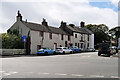

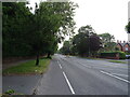
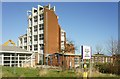

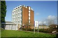


11 photos from this area
Area Information
Key information about the LA14 4HH including its size, population, and administrative classification.
- Area Type
- Postcode
- Area Size
- 6448 m²
- Population
- 1005
- Population Density
- 2486 people/km²
House Prices in LA14 4HH
18
Properties
£150,499
Average Sold Price
£57,500
Lowest Price
£285,000
Highest Price
Showing 18 properties
| Address | Type | Beds | Baths | Last Sale Price | Last Sale Date | |
|---|---|---|---|---|---|---|
| 4 Cowlarns Road, Barrow In Furness, LA14 4HH | Detached | 3 | 1 | £205,000 | May 2025 | |
| 7 Cowlarns Road, Barrow In Furness, LA14 4HH | Semi-detached | 3 | - | £285,000 | Apr 2025 | |
| 11 Cowlarns Road, Barrow In Furness, LA14 4HH | Semi-detached | 3 | 1 | £265,000 | Mar 2025 | |
| 10 Cowlarns Road, Barrow In Furness, LA14 4HH | house | - | - | £167,485 | May 2020 | |
| 3 Cowlarns Road, Barrow In Furness, LA14 4HH | Bungalow | - | - | £182,000 | Jul 2017 | |
| 8 Cowlarns Road, Barrow In Furness, LA14 4HH | Semi-detached | 3 | 1 | £150,000 | Oct 2015 | |
| 20 Cowlarns Road, Barrow In Furness, LA14 4HH | house | - | - | £200,000 | Apr 2015 | |
| 12 Cowlarns Road, Barrow In Furness, LA14 4HH | house | - | - | £163,000 | May 2013 | |
| 1 Cowlarns Road, Barrow In Furness, LA14 4HH | Semi-detached | 3 | 1 | £142,000 | Jul 2009 | |
| 13 Cowlarns Road, Barrow In Furness, LA14 4HH | Semi-detached | - | - | £179,000 | Jan 2006 |
Page 1 of 2
Energy Efficiency in LA14 4HH
Amenities
Schools
| Rank | School | Type | Entry gender | Ages |
|---|
Explore more schools in this area
Go to Schools tabDemographics
Household Size
Two person
most common
Accommodation Type
Houses
most common
Tenure
94
majority
Ethnic Group
White
most common
Religion
N/A
most common
Household Composition
N/A
most common
Age
47
median
Adults (30-64 years)
most common
Household Deprivation
N/A
with no deprivation
NS-SEC
40
in Lower managerial occupations
Explore more demographic insights in this area
Go to Demographics tabPlanning
Planning Constraints
- Flood RiskPremium
- Ramsar Wetland SitesPremium
- Area of Outstanding Natural BeautyPremium
- Protected Nature ReservePremium
- Protected WoodlandPremium