Area Overview for LA14 1PG
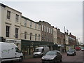
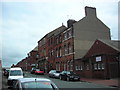
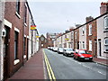
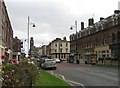
Photos of LA14 1PG


Area Information
Living in LA14 1PG offers a quiet, compact residential experience in a small cluster of homes. With a population of just 1308, the area feels close-knit, though its size means it’s more of a local hub than a sprawling town. The community is predominantly made up of adults aged 30-64, suggesting a stable, family-oriented demographic. Daily life here is shaped by proximity to essential services, including a primary school with a good Ofsted rating and multiple rail stations within reach. While the area lacks large-scale amenities, its practical connectivity to nearby towns via rail and ferry adds convenience. Digital connectivity is strong, with broadband and mobile scores of 80 and 81 respectively, supporting remote work or online activities. However, the high crime risk score of 1/100 is a concern, requiring residents to consider security measures. For those seeking a low-key, manageable lifestyle with access to transport and basic services, LA14 1PG could be a viable option, though its small size means it’s best suited for those prioritising proximity to larger centres over local vibrancy.
- Area Type
- Postcode
- Area Size
- Not available
- Population
- 1308
- Population Density
- 5826 people/km²
The property market in LA14 1PG is defined by a 47% home ownership rate, indicating that less than half of properties are owner-occupied. The remaining homes are likely in the rental market, though the exact proportion is not specified. The area is dominated by houses rather than flats, aligning with a traditional, family-focused housing stock. Given the small population and limited area, the housing supply is constrained, which may affect both availability and prices. Buyers should consider that the market is likely to be influenced by proximity to nearby towns, as the area itself lacks large-scale commercial or industrial development. For those seeking a home in this postcode, the focus would be on individual properties rather than broader estate developments. The absence of planning constraints or protected areas may offer flexibility in property modifications, though the high crime risk score could impact desirability.
House Prices in LA14 1PG
No properties found in this postcode.
Energy Efficiency in LA14 1PG
The lifestyle in LA14 1PG is shaped by its proximity to practical amenities. Within reach are five retail outlets, including Tesco Rawlinson and Iceland Barrow-In, offering everyday shopping needs. Four rail stations provide access to nearby towns, while Barrow Walney Island Airport caters to those requiring air travel. Two ferry landings—Roa Island and Piel Island—add a maritime dimension, ideal for leisure trips or commuting to nearby islands. The area’s small size means these amenities are tightly clustered, enhancing convenience for daily life. However, the absence of larger leisure facilities or parks suggests that residents may need to venture further for recreational activities. The mix of retail, transport, and coastal access creates a functional, though modest, lifestyle. The emphasis on rail and ferry connectivity positions the area as a practical base for those prioritising mobility over expansive local amenities.
Amenities
Schools
The nearest school to LA14 1PG is Ramsden Infant School, a primary institution with a good Ofsted rating. This suggests a reliable educational option for young children, though no secondary schools are listed in the data. The presence of a primary school with a positive rating is a key consideration for families with young dependents, as it reduces the need for long commutes to larger towns. However, the absence of secondary schools means parents may need to look further afield for secondary education. The school’s good rating indicates a focus on quality teaching and facilities, which could be a draw for families prioritising early education. Overall, the school infrastructure in LA14 1PG is limited but functional, with the primary school serving as the main local resource.
| Rank | School | Type | Entry gender | Ages |
|---|
Explore more schools in this area
Go to Schools tabDemographics
The population of LA14 1PG is 1308, with a median age of 47. The majority of residents fall within the 30-64 age range, indicating a mature, established community. Home ownership stands at 47%, suggesting a mix of owner-occupied properties and rental units. The area is characterised by houses rather than flats, reflecting a traditional housing stock. The predominant ethnic group is White, with no specific data on other demographics. While the data does not quantify deprivation levels, the high crime risk score of 1/100 implies potential challenges in safety and community well-being. This score, coupled with the absence of protected natural areas or planning constraints, suggests that quality of life here may hinge on local infrastructure and personal precautions. The demographic profile points to a stable, middle-aged population, which may influence local services and social dynamics.
Household Size
Accommodation Type
Tenure
Ethnic Group
Religion
Household Composition
Age
Household Deprivation
NS-SEC
Explore more demographic insights in this area
Go to Demographics tabPlanning
Planning Constraints
- Flood RiskPremium
- Ramsar Wetland SitesPremium
- Area of Outstanding Natural BeautyPremium
- Protected Nature ReservePremium
- Protected WoodlandPremium