Area Overview for LA14 1LR
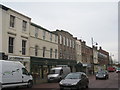
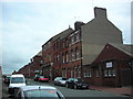
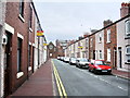
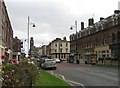
Photos of LA14 1LR


Area Information
Living in LA14 1LR offers a compact, tightly knit residential experience. This small postcode area covers just 882 square metres, housing 1,308 residents in a high-density setting. The community is predominantly composed of adults aged 30–64, with a median age of 47, suggesting a stable, mature population. The area’s small size means amenities and services are closely clustered, creating a convenient, self-contained environment. While it lacks the sprawling character of larger towns, its proximity to transport links and retail hubs makes it practical for daily life. The absence of major planning constraints, such as protected woodlands or AONB designations, ensures development remains unencumbered. However, the high population density—over 1.4 million people per square kilometre—means the area is intensely lived-in, with a focus on local connectivity over expansive open spaces. For those prioritising proximity to essential services, LA14 1LR provides a functional, if intimate, living environment.
- Area Type
- Postcode
- Area Size
- 882 m²
- Population
- 1308
- Population Density
- 5826 people/km²
The property market in LA14 1LR is characterised by a 47% home ownership rate, indicating a rental-dominated market. The accommodation type is primarily houses, which, given the area’s small size, suggests a limited stock of larger properties. This dynamic may create competition for buyers, as the housing stock is constrained by the postcode’s compact footprint. The absence of flats or apartments implies a preference for single-family homes, potentially appealing to families or those seeking more space. However, the high population density—over 1.4 million people per square kilometre—means properties are likely to be closely spaced. Buyers should consider the area’s proximity to transport links and amenities, which may offset the lack of expansive housing options. The market’s small scale means opportunities are limited, requiring buyers to look beyond immediate surroundings for broader choices.
House Prices in LA14 1LR
No properties found in this postcode.
Energy Efficiency in LA14 1LR
Daily life in LA14 1LR is shaped by its proximity to essential amenities. Retail options include Iceland Barrow-In and two Tesco locations, offering grocery and convenience shopping. The four rail stations—Barrow, Roose, and Dalton—provide easy access to regional transport, while Barrow Walney Island Airport offers limited flight connectivity. Ferries to Roa and Piel islands add a maritime dimension, ideal for leisure or short trips. The area’s compactness ensures amenities are within walking or short driving distance, fostering a self-sufficient lifestyle. While the absence of parks or leisure facilities is notable, the focus on retail, transport, and ferry access suggests a practical, utilitarian character. For residents prioritising convenience over expansive green spaces, LA14 1LR delivers a functional, if modest, lifestyle.
Amenities
Schools
The nearest school to LA14 1LR is Ramsden Infant School, a primary institution with a ‘good’ Ofsted rating. This school serves the local community, providing early education for young children. The absence of secondary schools in the data suggests families may need to look beyond the immediate area for comprehensive schooling. However, the presence of a well-rated primary school is a positive factor for those prioritising early education. The school’s ‘good’ rating indicates satisfactory standards in teaching and facilities, though parents should consider additional needs, such as secondary education or specialist provisions, which are not detailed here. For families with young children, Ramsden Infant School offers a reliable foundation, but broader educational options may require commuting.
| Rank | School | Type | Entry gender | Ages |
|---|
Explore more schools in this area
Go to Schools tabDemographics
The community in LA14 1LR is predominantly composed of adults aged 30–64, with a median age of 47. This suggests a population skewed towards middle-aged individuals, likely with established careers and families. Home ownership rates are relatively low at 47%, indicating a rental-heavy market. The accommodation type is primarily houses, which, combined with the high population density, implies a mix of larger properties shared among residents. The predominant ethnic group is White, reflecting a homogenous demographic profile. With no data on deprivation levels, it’s unclear how economic pressures might affect quality of life, but the age distribution and home ownership figures suggest a stable, if not affluent, community. The lack of diversity in ethnicity and the focus on owner-occupied housing point to a tightly defined social structure.
Household Size
Accommodation Type
Tenure
Ethnic Group
Religion
Household Composition
Age
Household Deprivation
NS-SEC
Explore more demographic insights in this area
Go to Demographics tabPlanning
Planning Constraints
- Flood RiskPremium
- Ramsar Wetland SitesPremium
- Area of Outstanding Natural BeautyPremium
- Protected Nature ReservePremium
- Protected WoodlandPremium