Area Overview for LA11 7GL
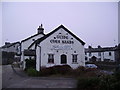
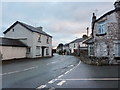
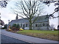
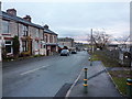
Photos of LA11 7GL

Area Information
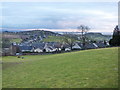
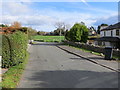
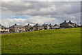
Living in LA11 7GL offers a quiet, residential experience in a small cluster of homes spread across a low-density area. With a population of 1,891 and a density of 59 people per square kilometre, the area feels uncluttered, ideal for those seeking a slower pace of life. The median age of 47 suggests a community of established residents, many of whom are adults aged 30–64. This is a predominantly owner-occupied area, with 81% of homes owned by residents, and the majority are houses rather than flats. The area’s proximity to schools, rail stations, and local shops means daily essentials are within reach, while its low crime risk score of 82 and no flood risk make it appealing for families. The lack of protected natural sites or planning constraints adds to its practicality, though the broadband score of 27 indicates limited fixed-line connectivity. For those prioritising safety, a low-risk environment and access to nearby amenities like Tesco Grange and Cark Railway Station make LA11 7GL a viable option for buyers seeking a balanced lifestyle.
- Area Type
- Postcode
- Area Size
- Not available
- Population
- 1891
- Population Density
- 59 people/km²
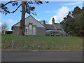
The property market in LA11 7GL is characterised by high home ownership, with 81% of properties owned by residents rather than rented. The area is predominantly composed of houses, which contrasts with regions where flats or apartments dominate. This suggests a market skewed towards owner-occupiers, likely attracting buyers seeking long-term stability. Given the small population and low density, the housing stock is limited, meaning properties in this area may be fewer but potentially more distinctive in character. The lack of protected natural sites or planning constraints could make development less restricted, though the broadband score of 27 may deter those reliant on high-speed internet. For buyers, the focus on owner-occupied homes and the prevalence of single-family dwellings indicate a community where properties are likely to be family homes rather than investment properties. Proximity to schools and transport links adds to the appeal, though the small size of the area means buyers should consider nearby surroundings for more options.
House Prices in LA11 7GL
No properties found in this postcode.
Energy Efficiency in LA11 7GL
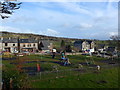
Residents of LA11 7GL have access to a range of local amenities within practical reach. Retail options include Tesco Grange, Co-op Grange, and Spar, providing everyday shopping needs. The area’s rail network, with five stations including Cark and Kents Bank, connects to nearby towns, while two metro stops at Haverthwaite and Newby Bridge offer additional transport links. Though specific parks or leisure facilities are not listed, the proximity to schools and transport hubs suggests a focus on practicality over large-scale recreational spaces. The low population density means the area likely retains a village-like character, with local shops and community hubs playing a central role. For those prioritising convenience, the combination of retail, transport, and nearby schools creates a self-contained environment. However, buyers should consider whether the lack of major leisure or cultural amenities aligns with their lifestyle preferences.
Amenities
Schools
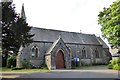
Residents of LA11 7GL have access to several primary schools, including Allithwaite CofE Primary School and Cartmel CofE Primary School, both rated 'good' by Ofsted. Cartmel Priory CofE School is listed twice, once as a primary school and once as an academy with the same 'good' rating. These options provide families with a mix of traditional state schools and academy-led institutions, though no secondary schools are mentioned. The presence of multiple primary schools within reach suggests a focus on early education, which is beneficial for families with young children. However, the absence of secondary school data means buyers may need to consider commuting options for older students. The 'good' Ofsted ratings indicate a baseline standard of education, but specific curriculum details or performance metrics are not provided. For those prioritising school quality, the variety of options in the area could be a deciding factor.
| Rank | School | Type | Entry gender | Ages |
|---|
Explore more schools in this area
Go to Schools tabDemographics
The community in LA11 7GL is defined by its age profile and home ownership rates. With a median age of 47 and the most common age range being adults aged 30–64, the area is dominated by middle-aged residents. Home ownership is high, at 81%, with most properties being houses rather than flats. This suggests a stable, long-term demographic with fewer transient tenants. The predominant ethnic group is White, though no specific diversity statistics are provided. The low population density of 59 people per square kilometre indicates a spread-out, less densely populated area. While no deprivation data is explicitly listed, the high home ownership and low crime risk imply a relatively secure, self-sufficient community. The absence of protected natural areas or planning constraints may contribute to a lower cost of living compared to more regulated regions. For buyers, this demographic profile suggests a neighbourhood with established residents and limited turnover, which could influence property values and local services.
Household Size
Accommodation Type
Tenure
Ethnic Group
Religion
Household Composition
Age
Household Deprivation
NS-SEC
Explore more demographic insights in this area
Go to Demographics tabPlanning
Planning Constraints
- Flood RiskPremium
- Ramsar Wetland SitesPremium
- Area of Outstanding Natural BeautyPremium
- Protected Nature ReservePremium
- Protected WoodlandPremium