Area Overview for L9 7EW
Photos of L9 7EW
Area Information
Living in L9 7EW means being part of a compact, residential postcode area in England with a population of 1,828 people. The area’s high population density of 1,135 people per square kilometre suggests a tightly knit community, likely centred around local amenities and transport links. This postcode is not a sprawling suburb but a focused cluster of homes, making it ideal for those seeking proximity to services without the sprawl of larger towns. Daily life here is shaped by nearby retail, rail, and ferry connections, which provide both practicality and access to broader networks. The area’s character is defined by its mix of small-scale living and connectivity, with residents able to reach shops, schools, and transport hubs within short distances. While the data does not indicate specific cultural or historical features, the presence of multiple schools and transport options suggests a functional, family-oriented environment. For buyers, L9 7EW offers a blend of residential comfort and accessibility, though its small size means the immediate surroundings are key to understanding its full appeal.
- Area Type
- Postcode
- Area Size
- Not available
- Population
- 1828
- Population Density
- 1135 people/km²
The property market in L9 7EW is shaped by its 37% home ownership rate, which suggests that a majority of properties are rented rather than owner-occupied. The accommodation type is primarily houses, which may indicate a preference for single-family homes over apartments or flats. This could make the area more attractive to buyers seeking larger living spaces or those looking to invest in rental properties. However, the small size of the postcode means the housing stock is limited, and buyers may need to consider nearby areas for more options. The lower home ownership rate might also reflect economic factors, such as affordability challenges or a higher proportion of younger residents in the rental market. For those considering purchase, the focus on houses suggests a market where space and privacy are prioritised, though the limited scale of the area could mean competition for available properties.
House Prices in L9 7EW
No properties found in this postcode.
Energy Efficiency in L9 7EW
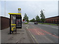
Daily life in L9 7EW is supported by a range of nearby amenities, including five retail outlets such as Lidl Fazakerley, Tesco Fazakerley, and Iceland Walton. These shops provide access to groceries, household goods, and everyday essentials, reducing the need for long journeys. The area’s rail stations and ferry terminals further enhance connectivity, allowing residents to reach larger urban centres or coastal destinations with ease. While the data does not specify parks or leisure facilities, the presence of multiple transport hubs and retail options suggests a practical, service-oriented lifestyle. The proximity to schools and transport links may also make the area appealing to families and commuters. However, the absence of detailed information on recreational spaces means residents might need to look beyond L9 7EW for parks or leisure activities. Overall, the area offers a balance of convenience and accessibility, though its small size means the full breadth of lifestyle options depends on nearby locations.
Amenities
Schools
Residents of L9 7EW have access to a range of schools, including three primary schools: St Philomena’s RC Junior School, St Philomena’s RC Infants’ School, and Our Lady and St Philomena’s Catholic Primary School, which holds an Ofsted rating of ‘good’. Two special schools, Redbridge High School and Fazakerley Open Air School, cater to specific educational needs. The mix of primary and special schools provides options for families with children of varying ages and requirements. However, the absence of secondary schools in the immediate area means parents may need to look beyond L9 7EW for high school placements. This could be a consideration for families planning long-term residency. The presence of multiple schools, particularly the ‘good’-rated primary, suggests a focus on early education and support for diverse learning needs, though the lack of secondary options may require additional commuting.
| Rank | School | Type | Entry gender | Ages |
|---|
Explore more schools in this area
Go to Schools tabDemographics
The community in L9 7EW is predominantly composed of adults aged 30–64, with a median age of 47. This suggests a mature population, likely with established careers and family structures. Home ownership stands at 37%, which is below the national average, indicating that a significant portion of the housing stock is rented. The area is characterised by houses rather than flats, which may appeal to those seeking more space or privacy. The predominant ethnic group is White, and while no specific data on deprivation is provided, the relatively high proportion of owner-occupied homes could imply a stable, long-term resident base. The age profile suggests a community with a mix of working-age individuals and retirees, potentially creating a balance between active employment and retirement lifestyles. This demographic mix may influence local services, with schools and amenities tailored to a range of age groups.
Household Size
Accommodation Type
Tenure
Ethnic Group
Religion
Household Composition
Age
Household Deprivation
NS-SEC
Explore more demographic insights in this area
Go to Demographics tabPlanning
Planning Constraints
- Flood RiskPremium
- Ramsar Wetland SitesPremium
- Area of Outstanding Natural BeautyPremium
- Protected Nature ReservePremium
- Protected WoodlandPremium