Area Overview for L5 8ST
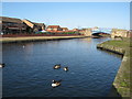
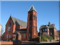
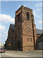
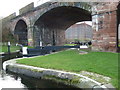
Photos of L5 8ST


Area Information
Living in L5 8ST means being part of a small, tightly knit residential cluster in England, where the population of 2032 reflects a quiet, community-focused environment. This area is characterised by its modest scale, with homes predominantly in the form of individual properties rather than high-density housing. The median age of 47 suggests a mature demographic, with adults aged 30–64 making up the largest share of the population. Daily life here is shaped by proximity to essential services and transport links, including nearby rail stations and ferry terminals. The area’s broadband score of 98 ensures seamless digital connectivity, while its mobile coverage of 85 supports reliable communication. Though crime rates are average, with a safety score of 37, residents are advised to take standard precautions. L5 8ST offers a blend of practicality and accessibility, with schools, shops, and transport options within reach, making it suitable for those prioritising convenience over urban vibrancy.
- Area Type
- Postcode
- Area Size
- Not available
- Population
- 2032
- Population Density
- 4904 people/km²
The property market in L5 8ST is defined by its low home ownership rate of 23%, which implies that the area is more rental-focused than owner-occupied. This suggests a limited number of properties available for purchase, with most homes likely rented out to tenants. The accommodation type is predominantly houses, which are typically larger and more suited to families or individuals seeking space. Given the area’s small size, the housing stock is unlikely to be extensive, meaning buyers may find limited options within L5 8ST itself. Those considering the area should look to nearby regions for a broader selection of properties. The mix of rental availability and house-based housing indicates a market that prioritises stability for tenants over investment opportunities for buyers. This dynamic may appeal to those seeking long-term rental solutions rather than property ownership.
House Prices in L5 8ST
No properties found in this postcode.
Energy Efficiency in L5 8ST
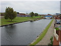
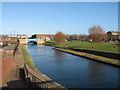
Lifestyle in L5 8ST is shaped by its proximity to essential amenities, including retail outlets like Spar, Sainsburys Liverpool Great, and Lidl LIV, which cater to everyday shopping needs. The area’s rail stations and ferry terminals provide easy access to nearby towns and cities, enhancing both practicality and leisure opportunities. While the data does not specify parks or leisure facilities, the presence of multiple transport links and retail options suggests a focus on convenience over expansive recreational spaces. Residents can enjoy a mix of local shopping and efficient travel, with the broadband infrastructure supporting digital engagement. The small-scale nature of the area means amenities are concentrated, reducing the need for long commutes. This balance of accessibility and compactness makes L5 8ST appealing to those who value practicality and ease of access in daily life.
Amenities
Schools
Residents of L5 8ST have access to several primary schools, including St Gerard’s Catholic Primary School, Our Lady and St Nicholas CofE School, St Gerard’s RC Junior School, and St Brigid’s RC High School. While all listed institutions are primary schools, the presence of multiple options within the area provides families with choices in education. The variety of school types—Catholic and Church of England—reflects the area’s religious diversity and offers different educational philosophies. However, no secondary schools are explicitly mentioned in the data, meaning families may need to look beyond L5 8ST for high school options. The concentration of primary schools is a clear advantage for parents with young children, ensuring proximity to education. The absence of secondary school data does not detract from the immediate availability of primary schooling, which is a key consideration for families prioritising early education.
| Rank | School | Type | Entry gender | Ages |
|---|
Explore more schools in this area
Go to Schools tabDemographics
The community in L5 8ST is predominantly composed of adults aged 30–64, with a median age of 47. This reflects a population that is neither young nor elderly, suggesting stability and established households. Home ownership is relatively low at 23%, indicating that a significant portion of residents are likely to be renters. The area is characterised by houses rather than flats or apartments, which aligns with its small-scale residential nature. The predominant ethnic group is White, with no specific data provided on other demographics. The age profile and housing stock suggest a community that is family-oriented but not densely populated. With 2032 residents, the area is small enough to foster familiarity yet diverse enough to support a range of local needs. The absence of detailed diversity statistics means the community’s composition remains largely defined by its demographic and housing characteristics.
Household Size
Accommodation Type
Tenure
Ethnic Group
Religion
Household Composition
Age
Household Deprivation
NS-SEC
Explore more demographic insights in this area
Go to Demographics tabPlanning
Planning Constraints
- Flood RiskPremium
- Ramsar Wetland SitesPremium
- Area of Outstanding Natural BeautyPremium
- Protected Nature ReservePremium
- Protected WoodlandPremium