Area Overview for L43 3DZ
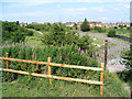
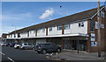
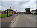
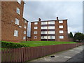
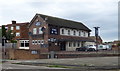
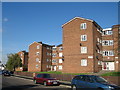
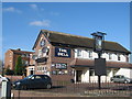
Photos of L43 3DZ


Area Information
Living in L43 3DZ means inhabiting a small, tightly knit residential cluster in the heart of Prenton, a suburb of Birkenhead. With a population of 1,473, this area balances quiet suburban life with proximity to key transport links. Historically a rural hamlet recorded as *Prestune* in the Domesday Book, Prenton evolved into a settled community by the early 20th century. Today, it is bounded by the M53 motorway to the west and bordered by Oxton, Tranmere, and Rock Ferry. The area’s character is defined by its mix of older housing stock and modern infrastructure, with amenities like Morrisons Daily and Asda within reach. Residents benefit from multiple rail stations, including Upton and Rock Ferry, and ferry terminals connecting to Birkenhead and Seacombe. The low crime score of 74/100 and no flood risk make it appealing for families seeking stability. Its compact size fosters a close-knit community, where landmarks like the Prenton War Memorial and Halfway House pub anchor local identity. For those prioritising safety, convenience, and historical roots, L43 3DZ offers a grounded alternative to larger urban centres.
- Area Type
- Postcode
- Area Size
- Not available
- Population
- Not available
- Population Density
- Not available
The property market in L43 3DZ is dominated by owner-occupied homes, with 88% of properties in private ownership. This high rate of home ownership suggests a community focused on long-term investment rather than rental income, which is uncommon in many urban areas. The accommodation type is exclusively houses, indicating a lack of flats or apartments. This housing stock likely appeals to families and individuals seeking larger living spaces, though the small area size means the number of available properties is limited. The predominance of houses may also mean fewer opportunities for younger buyers or those seeking smaller units. For those considering purchase, the area’s stability and low crime risk enhance its appeal, though the limited property pool could drive competition. Buyers should also consider the proximity to transport links like the M53 and rail stations, which may influence property values and desirability.
House Prices in L43 3DZ
No properties found in this postcode.
Energy Efficiency in L43 3DZ
Residents of L43 3DZ have access to a range of essential amenities within practical reach. Retail options include Morrisons Daily Wirral, Morrisons Daily, and Asda Arrowe, providing grocery and daily shopping convenience. The area’s rail network, with stations like Upton and Rock Ferry, facilitates easy travel to Liverpool and other destinations, while ferry terminals at Woodside Birkenhead, Birkenhead, and Seacombe offer direct water transport links. Though the data does not specify parks or leisure facilities, the proximity to Prenton’s historical landmarks, such as the Grade II-listed Prenton War Memorial, suggests a community with cultural and historical interests. The presence of the Halfway House pub, licensed since at least 1879, adds a touch of local character. These amenities collectively support a lifestyle that balances practicality with a connection to the area’s heritage and transport flexibility.
Amenities
Schools
| Rank | School | Type | Entry gender | Ages |
|---|
Explore more schools in this area
Go to Schools tabDemographics
The population of L43 3DZ has a median age of 47, with the majority of residents falling within the 30-64 age range. This suggests a community skewed towards middle-aged adults, likely including families and professionals. Home ownership is exceptionally high at 88%, indicating a strong preference for long-term residency over rental properties. The accommodation type is predominantly houses, reflecting a traditional, family-oriented housing stock. The predominant ethnic group is White, though no specific diversity statistics are provided. The absence of data on other ethnic groups means the community’s demographic composition remains largely unquantified beyond this. With 88% of homes owned outright, the area likely experiences lower housing turnover, contributing to a stable, familiar neighbourhood environment. This profile aligns with a mature, settled population prioritising security and established living conditions over transient lifestyles.
Household Size
Accommodation Type
Tenure
Ethnic Group
Religion
Household Composition
Age
Household Deprivation
NS-SEC
Explore more demographic insights in this area
Go to Demographics tabPlanning
Planning Constraints
- Flood RiskPremium
- Ramsar Wetland SitesPremium
- Area of Outstanding Natural BeautyPremium
- Protected Nature ReservePremium
- Protected WoodlandPremium