Area Overview for L41 8FG
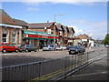
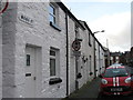
Photos of L41 8FG


Area Information
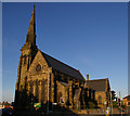
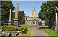
Living in L41 8FG means residing in a small, tightly knit residential cluster within the Wirral peninsula, bounded by the River Mersey and River Dee. The area’s population of 1,554 reflects its compact nature, with a mix of historic and modern elements shaping daily life. Bidston, the village at its core, retains medieval roots, including Bidston Hall and St Oswald’s Church, while nearby Bidston Hill offers heathland walks and a 19th-century windmill. The area’s proximity to Birkenhead and the broader Wirral makes it a commuter hub, with rail and ferry links to Liverpool and beyond. Residents benefit from a blend of rural tranquillity and urban accessibility, with local amenities like Asda and Tesco within reach. The community’s character is defined by its historical significance, from Domesday Book records to restored nature reserves like Bidston Moss. This is a place where heritage meets practicality, offering a quiet lifestyle without sacrificing connectivity to major services.
- Area Type
- Postcode
- Area Size
- Not available
- Population
- 1554
- Population Density
- 5348 people/km²
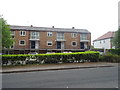
The property market in L41 8FG is characterised by a low home ownership rate of 23%, suggesting that most housing stock is rented rather than owned. The area’s accommodation is primarily houses, which are likely to be older properties given the historical context of Bidston. Many of these homes date from the 16th to 18th centuries, with some Grade II listed buildings adding architectural value. This mix of historic and traditional housing may appeal to buyers seeking characterful homes, though the limited ownership rate indicates a reliance on rental properties. The small size of the area means that buyers may need to look beyond immediate surroundings for a broader selection of properties. For those prioritising owner-occupation, the market’s constraints could necessitate considering nearby wards with more available options.
House Prices in L41 8FG
No properties found in this postcode.
Energy Efficiency in L41 8FG
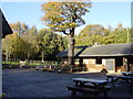
The lifestyle in L41 8FG is shaped by its mix of local amenities and natural spaces. Residents have access to retail options such as Asda Birkenhead, Aldi Laird, and Tesco Claughton, ensuring convenience for shopping. The area’s proximity to Bidston Hill, a 100-acre heathland with a windmill and observatory, offers recreational opportunities for walking and outdoor activities. Bidston Moss, a restored nature reserve, adds to the green spaces available. The village’s historical sites, including Bidston Hall and St Oswald’s Church, provide cultural enrichment. Practical transport links via rail and ferry enhance accessibility, while the compact size of the area ensures that amenities are within easy reach. This blend of natural beauty, historical interest, and modern convenience defines the daily life of residents.
Amenities
Schools
Residents of L41 8FG have access to Portland Primary School, a primary institution serving local children, and Co-op Academy Portland, an academy with an Ofsted rating of satisfactory. The presence of both a primary school and an academy provides families with options for different educational approaches, though the academy’s rating suggests room for improvement. These schools are likely to be key considerations for homebuyers prioritising proximity to education. The area’s schools are positioned within practical reach of the postcode, making them accessible for daily commutes. While no specific data on school performance beyond Ofsted ratings is provided, the mix of school types reflects a balance between traditional and alternative educational models.
| Rank | School | Type | Entry gender | Ages |
|---|
Explore more schools in this area
Go to Schools tabDemographics
The population of L41 8FG has a median age of 47, with the majority of residents falling in the 30–64 age range. This suggests a community dominated by working-age adults, likely including families and professionals. Home ownership is relatively low at 23%, indicating that most households are renters, which may influence the local property market’s dynamics. The area’s accommodation is primarily houses, reflecting a preference for standalone homes over flats. The predominant ethnic group is White, which aligns with broader trends in Wirral. While specific data on deprivation is not provided, the low home ownership rate and older demographic may imply a mix of long-term residents and those in rental accommodation. The absence of detailed diversity metrics means the community’s composition remains largely unquantified beyond these parameters.
Household Size
Accommodation Type
Tenure
Ethnic Group
Religion
Household Composition
Age
Household Deprivation
NS-SEC
Explore more demographic insights in this area
Go to Demographics tabPlanning
Planning Constraints
- Flood RiskPremium
- Ramsar Wetland SitesPremium
- Area of Outstanding Natural BeautyPremium
- Protected Nature ReservePremium
- Protected WoodlandPremium