Area Overview for L36 3XZ
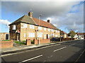
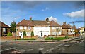
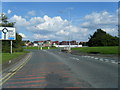
Photos of L36 3XZ


Area Information
Living in L36 3XZ means being part of a small, tightly knit residential cluster in England. With a population of 2,698, this area offers a quiet, community-focused lifestyle. The postcode covers a compact area where daily life is shaped by proximity to essential services and transport links. Residents benefit from a mix of local amenities, including retail outlets, railway stations, and ferry terminals, which connect them to nearby cities and beyond. The area’s modest size fosters a sense of familiarity, though it remains practical for those needing access to larger urban hubs. The demographic profile suggests a mature population, with adults aged 30–64 forming the majority. While the area lacks large-scale attractions, its strategic location near Liverpool John Lennon Airport and ferry routes adds to its appeal for commuters and those prioritising connectivity. For buyers seeking a balance between tranquillity and accessibility, L36 3XZ presents a straightforward option, though its small scale means limited housing stock and minimal development potential.
- Area Type
- Postcode
- Area Size
- Not available
- Population
- 2698
- Population Density
- 5218 people/km²
The property market in L36 3XZ is defined by a 47% home ownership rate, with houses being the predominant accommodation type. This indicates a market skewed towards owner-occupied properties rather than rental units, though the relatively low home ownership percentage suggests a significant portion of the housing stock is rented. The small size of the area means the housing stock is limited, with little scope for new developments. Buyers should expect a selection of individual homes rather than apartments or larger estates. The lack of protected land or planning constraints may allow for some flexibility in property use, but the area’s compact nature means competition for available homes could be keen. For those seeking a long-term investment, the mix of owner-occupied and rental properties offers opportunities, though the small scale of the area means buyers must consider proximity to larger urban centres for more extensive options.
House Prices in L36 3XZ
No properties found in this postcode.
Energy Efficiency in L36 3XZ
Residents of L36 3XZ have access to a range of nearby amenities that support daily life. The area includes five retail outlets, such as Farmfoods Fincham, Lidl Fincham, and Tesco Huyton, providing essential shopping options. For transport, five railway stations—Roby, Huyton, and Broad Green—offer connections to Liverpool and surrounding areas. The proximity to Liverpool John Lennon Airport and two ferry terminals, including Liverpool Pier Head, enhances travel flexibility. While the area lacks large parks or leisure facilities, the absence of protected natural sites means no restrictions on local development. The mix of retail, rail, and air links creates a functional lifestyle, though residents may need to travel further for more extensive recreational options. The practical reach of these amenities ensures a self-sufficient, though modest, lifestyle for those prioritising convenience over expansive leisure opportunities.
Amenities
Schools
| Rank | School | Type | Entry gender | Ages |
|---|
Explore more schools in this area
Go to Schools tabDemographics
The community in L36 3XZ is predominantly composed of adults aged 30–64, with a median age of 47. This suggests a mature population, likely with established careers and families. Home ownership stands at 47%, indicating a mix of owner-occupied properties and rental units. The area is characterised by houses rather than flats, which aligns with the demographic profile of older, settled residents. The predominant ethnic group is White, reflecting a lack of significant diversity in the local population. While no specific deprivation data is provided, the absence of protected natural areas or flood risk suggests a relatively stable environment. However, the medium crime risk score of 35/100 implies that standard security measures are advisable. The age distribution and housing type suggest a community focused on long-term stability rather than transient populations, which may influence local social dynamics and service provision.
Household Size
Accommodation Type
Tenure
Ethnic Group
Religion
Household Composition
Age
Household Deprivation
NS-SEC
Explore more demographic insights in this area
Go to Demographics tabPlanning
Planning Constraints
- Flood RiskPremium
- Ramsar Wetland SitesPremium
- Area of Outstanding Natural BeautyPremium
- Protected Nature ReservePremium
- Protected WoodlandPremium