Area Overview for L33 9UP
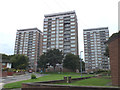
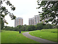
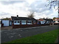
Photos of L33 9UP


Area Information
Living in L33 9UP means being part of a tightly knit residential cluster in England, home to 2,316 residents. This small area is characterised by a mature population, with a median age of 47 and a majority of adults aged 30–64. The community leans towards homeownership, with 52% of properties owned by residents rather than rented. The area is defined by its housing stock, which predominantly consists of houses rather than flats, reflecting a traditional, family-oriented environment. Daily life here is shaped by proximity to essential services: five rail stations, including Headbolt Lane and Kirkby, provide easy access to regional transport networks. The broadband score of 100 ensures seamless internet connectivity, while mobile coverage of 85 is reliable for most needs. Though small, L33 9UP offers a balance of practicality and accessibility, with nearby amenities such as supermarkets, a ferry terminal, and a range of schools. Its compact size means residents can navigate local life on foot or by bike, with minimal reliance on cars. For those seeking a quiet, established community with strong infrastructure, L33 9UP provides a stable foundation.
- Area Type
- Postcode
- Area Size
- Not available
- Population
- 2316
- Population Density
- 4024 people/km²
The property market in L33 9UP is defined by a 52% home ownership rate, which suggests a mix of owner-occupied and rental properties. The accommodation type is predominantly houses, indicating a lack of high-density housing such as flats or apartments. This makes the area more suited to families or individuals seeking space rather than urban convenience. Given the small size of the postcode, the housing stock is limited, and buyers should consider the surrounding areas for more options. The presence of houses rather than rental properties implies that the market may be more competitive for first-time buyers, with fewer properties available for purchase compared to areas with higher rental turnover. The area’s compact nature also means that property values may be influenced by proximity to amenities like schools and transport links. For those prioritising space and stability, L33 9UP offers a traditional housing environment, but buyers should be prepared for a smaller selection of properties.
House Prices in L33 9UP
No properties found in this postcode.
Energy Efficiency in L33 9UP
The lifestyle in L33 9UP is shaped by its proximity to essential amenities within practical reach. Residents can access five rail stations, including Headbolt Lane and Kirkby, which provide direct links to regional hubs. Retail options like Morrisons Kirkby and Farmfoods Northwood cater to daily shopping needs, while the Liverpool Belfast Ferry Terminal Bootle offers a unique connection to nearby cities. Though the area is small, it avoids the congestion of larger towns, making it ideal for those who value convenience without urban chaos. The presence of multiple schools and a mix of retail outlets suggests a community that prioritises family-friendly living. Parks or green spaces are not explicitly mentioned, but the lack of protected natural areas means residents are unlikely to face planning restrictions that limit leisure activities. Overall, L33 9UP offers a straightforward lifestyle where essentials are nearby, and the compact size ensures a sense of local cohesion.
Amenities
Schools
Residents of L33 9UP have access to a range of primary schools, including Overdale Primary School, Ravenscroft Community Primary School (rated ‘good’ by Ofsted), Ruffwood School, Overdale County Junior School, and All Saints Catholic High School (also rated ‘good’). The presence of multiple primary schools within the area ensures that families have options for their children’s early education, reducing the need for long commutes. The two ‘good’-rated schools—Ravenscroft and All Saints—suggest that some institutions meet or exceed national standards, though others are not rated. The variety of school types, from community to Catholic, reflects the area’s diversity in educational provision. For families prioritising school quality, the ‘good’ ratings are a positive indicator, but parents should visit schools to assess their suitability. The proximity of these schools to homes in L33 9UP makes it a practical choice for families seeking a balance between convenience and educational options.
| Rank | School | Type | Entry gender | Ages |
|---|
Explore more schools in this area
Go to Schools tabDemographics
The population of L33 9UP is 2,316, with a median age of 47, indicating a community skewed towards middle-aged adults. Over half (52%) of residents own their homes, a figure that suggests stability and long-term residency. The area is dominated by houses, with no flats or apartments recorded, reflecting a preference for larger, family-oriented properties. The predominant ethnic group is White, though specific data on diversity is not provided. The age profile shows that 30–64-year-olds make up the largest cohort, which influences the area’s social dynamics and local services. This demographic also means that the community is less likely to have a high proportion of young families or elderly residents. The absence of detailed deprivation data means quality of life can only be inferred from available metrics, such as the broadband score of 100 and the presence of multiple schools. Overall, L33 9UP is a mature, low-mobility area where residents are likely to have established careers and family ties.
Household Size
Accommodation Type
Tenure
Ethnic Group
Religion
Household Composition
Age
Household Deprivation
NS-SEC
Explore more demographic insights in this area
Go to Demographics tabPlanning
Planning Constraints
- Flood RiskPremium
- Ramsar Wetland SitesPremium
- Area of Outstanding Natural BeautyPremium
- Protected Nature ReservePremium
- Protected WoodlandPremium