Area Overview for L33 8YT
Photos of L33 8YT


Area Information
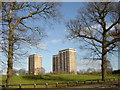
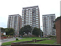
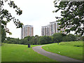
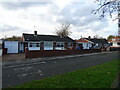
Living in L33 8YT offers a quiet, residential experience in a small cluster of homes. With a population of 1,382, the area feels intimate, shaped by its modest size and the presence of family-oriented housing. The community is predominantly composed of adults aged 30–64, many of whom own their homes. Daily life here is defined by proximity to essential services, including five retail outlets such as Morrisons Kirkby and Farmfoods Northwood, and easy access to rail networks like Headbolt Lane and Kirkby stations. A ferry terminal in nearby Bootle connects residents to Liverpool and Belfast, adding to the area’s practicality. The broadband score of 91 and mobile coverage of 85 ensure reliable connectivity for remote work or online activities. While the area lacks natural beauty designations, its low flood risk and absence of planning constraints make it a stable choice for those seeking a balanced lifestyle with access to both urban and transport links.
- Area Type
- Postcode
- Area Size
- Not available
- Population
- 1382
- Population Density
- 5627 people/km²
The property market in L33 8YT is characterised by a low home ownership rate of 31%, suggesting that a significant proportion of the housing stock is rented out. The area is primarily composed of houses, which are more common than flats or other forms of accommodation. This makes it an unusual postcode in terms of housing stock, as many similar areas in the UK have a higher proportion of flats. The limited number of properties—given the small population—means that the market is likely to be tightly held, with limited turnover. For buyers, this could mean fewer options but potentially more stability in property values. The predominance of houses may appeal to those seeking larger, family-friendly homes, though the low ownership rate could indicate challenges in finding available properties for purchase.
House Prices in L33 8YT
No properties found in this postcode.
Energy Efficiency in L33 8YT
Lifestyle in L33 8YT is shaped by its proximity to retail, transport, and regional links. Five retail outlets, including Morrisons Kirkby and Farmfoods Northwood, provide everyday shopping needs, while Heron Northwood adds variety. The rail network offers easy access to cities like Liverpool, with stations such as Headbolt Lane and Kirkby facilitating daily commutes. A ferry terminal in Bootle connects residents to Belfast and Liverpool, broadening travel options. Though the area is small, its amenities cater to practical living, with shops and transport hubs within reach. The absence of large parks or leisure facilities means residents may need to travel for recreation, but the convenience of nearby rail links compensates. Overall, the area balances simplicity with connectivity, making it suitable for those prioritising accessibility over expansive amenities.
Amenities
Schools
The nearest school to L33 8YT is Northwood Community Primary School, which provides education for younger children. This school is designated with special provisions, indicating it caters to students with additional needs. Its Ofsted rating of ‘good’ suggests a satisfactory standard of education, though it is not a secondary school. Families with children may need to look further afield for secondary education options. The presence of a primary school within reach is a practical benefit for parents, reducing the need for long commutes. However, the absence of secondary schools in the immediate area means that students may need to travel to nearby towns for higher education. This could be a consideration for families planning long-term in the area.
| Rank | School | Type | Entry gender | Ages |
|---|
Explore more schools in this area
Go to Schools tabDemographics
The demographic profile of L33 8YT reflects a mature community, with a median age of 47 and the majority of residents falling within the 30–64 age range. Home ownership stands at 31%, suggesting a mix of owner-occupied properties and rental units. The accommodation type is predominantly houses, which aligns with the area’s small, residential character. The predominant ethnic group is White, indicating a homogenous population. While no specific deprivation data is provided, the age distribution suggests a stable, established community with fewer young families. This demographic profile may influence local amenities and services, catering more to adult needs than those of children. The relatively low home ownership rate could indicate a reliance on rental properties, which may affect property market dynamics in the area.
Household Size
Accommodation Type
Tenure
Ethnic Group
Religion
Household Composition
Age
Household Deprivation
NS-SEC
Explore more demographic insights in this area
Go to Demographics tabPlanning
Planning Constraints
- Flood RiskPremium
- Ramsar Wetland SitesPremium
- Area of Outstanding Natural BeautyPremium
- Protected Nature ReservePremium
- Protected WoodlandPremium