Area Overview for L32 8ZL
Photos of L32 8ZL


Area Information
Living in L32 8ZL means being part of a tightly knit residential cluster in England, home to 1,389 people. This small area is defined by its compact size and proximity to practical amenities, including rail stations and a ferry terminal. Daily life here is shaped by its modest scale, with a community that leans toward mature adults aged 30–64. The area’s low flood risk and absence of environmental constraints like protected woodlands or AONB coverage suggest a straightforward living environment. However, the high crime risk score of 2/100 indicates a need for vigilance. Residents benefit from excellent broadband connectivity, rated 100, and good mobile coverage, which supports remote work and everyday internet use. The area’s appeal lies in its accessibility to nearby towns via rail and its direct link to the Liverpool Belfast Ferry Terminal, offering easy travel options. While the population is small, the presence of five retail outlets, including Farmfoods Northwood and Iceland Kirkby, ensures basic shopping needs are met. L32 8ZL is not a place for those seeking luxury or sprawling landscapes, but it offers functional living for those prioritising convenience and connectivity.
- Area Type
- Postcode
- Area Size
- Not available
- Population
- 1389
- Population Density
- 2536 people/km²
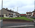
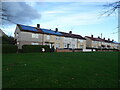
The property market in L32 8ZL is characterised by a 38% home ownership rate, meaning that over two-thirds of residents rent their homes. The area’s accommodation is primarily houses, which may indicate a focus on family-friendly or larger properties. This suggests a market where owner-occupied homes are not the norm, and rental demand could drive property dynamics. For buyers, the small size of the area means that the housing stock is limited, and competition may be fierce for available properties. The presence of houses rather than flats or apartments implies a preference for more private, spacious living. However, the low home ownership rate raises questions about long-term investment potential, as rental yields and property appreciation may depend on local economic factors. Buyers should consider the area’s compact nature and its proximity to transport links, which could enhance its appeal to commuters or those seeking easy access to nearby towns.
House Prices in L32 8ZL
No properties found in this postcode.
Energy Efficiency in L32 8ZL
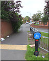
Life in L32 8ZL is shaped by its proximity to essential amenities, including five retail outlets such as Farmfoods Northwood, Iceland Kirkby, and Heron Northwood. These stores provide access to groceries, household goods, and other daily necessities. The area’s rail network, with stations like Headbolt Lane and Fazakerley, ensures easy commuting to nearby employment hubs. The Liverpool Belfast Ferry Terminal in Bootle offers a direct link to Liverpool, enhancing travel options for residents. While the area lacks large leisure or entertainment venues, the nearby retail options and transport links create a functional lifestyle. The small population and limited local amenities mean that residents may need to travel further for dining or cultural activities. However, the practical reach of shops and transport makes daily life convenient, particularly for those prioritising accessibility over sprawling urban amenities. The area’s character is defined by its simplicity and utility, catering to those who value efficiency over luxury.
Amenities
Schools
| Rank | School | Type | Entry gender | Ages |
|---|
Explore more schools in this area
Go to Schools tabDemographics
The community in L32 8ZL is predominantly composed of adults aged 30–64, with a median age of 47. This suggests a mature population, likely with established careers and families. Home ownership rates stand at 38%, meaning a majority of residents rent their homes. The area’s accommodation is largely made up of houses, which may indicate a mix of family homes and more spacious properties. The predominant ethnic group is White, reflecting a homogenous demographic profile. With a population of 1,389, the area is small enough to foster a close-knit community but limited in scale to offer diverse social or cultural amenities. The low home ownership rate implies a rental market that may influence property values and availability. For buyers, this suggests a market where owner-occupied homes are less common, and renters may dominate. The age distribution also points to a community with stable employment patterns, though the absence of detailed data on deprivation means the impact of socioeconomic factors remains unclear.
Household Size
Accommodation Type
Tenure
Ethnic Group
Religion
Household Composition
Age
Household Deprivation
NS-SEC
Explore more demographic insights in this area
Go to Demographics tabPlanning
Planning Constraints
- Flood RiskPremium
- Ramsar Wetland SitesPremium
- Area of Outstanding Natural BeautyPremium
- Protected Nature ReservePremium
- Protected WoodlandPremium