Area Overview for L30 6TU
Photos of L30 6TU


Area Information
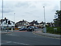
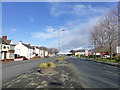
Living in L30 6TU means inhabiting a tightly packed residential cluster in England, where 1,780 people reside across 9,686 square metres. The area’s compact size fosters a close-knit community feel, though its high population density of 183,774 people per square kilometre reflects its small, intensively used footprint. This postcode is defined by its proximity to practical amenities, including retail hubs, rail links, and ferry terminals, which make daily life convenient. The area’s demographic profile suggests a mature population, with a median age of 47 and a majority of residents aged 30–64. Most homes are owner-occupied, with 81% of properties in private hands, indicating a stable, long-term community. While the area lacks natural or protected landscapes, its accessibility to transport networks and retail options positions it as a functional, if modest, urban living space. For buyers, L30 6TU offers a snapshot of a residential postcode where practicality and proximity to services outweigh expansive open spaces.
- Area Type
- Postcode
- Area Size
- 9686 m²
- Population
- 1780
- Population Density
- 3895 people/km²
The property market in L30 6TU is characterised by a high rate of home ownership, with 81% of properties in private hands. This suggests a market where long-term residency is the norm, rather than a transient rental sector. The accommodation type is predominantly houses, which, given the area’s small size, implies a limited but concentrated housing stock. For buyers, this means a focus on individual properties rather than larger developments. The compact nature of the postcode means the housing stock is unlikely to expand significantly, making each property within the area or its immediate surroundings particularly valuable. The high ownership rate also indicates a lack of speculative investment, with properties likely held by residents rather than institutional landlords. This creates a stable market, though buyers should consider the limited availability of new builds or larger properties.
House Prices in L30 6TU
No properties found in this postcode.
Energy Efficiency in L30 6TU
Residents of L30 6TU have access to a range of amenities within practical reach. Retail options include Spar Dunningsbridge, M&S Aintree, and Aldi Netherton, providing everyday shopping convenience. The area’s rail network, with stations such as Aintree and Fazakerley, offers easy access to nearby towns and cities, while ferry terminals like Liverpool Belfast and Seacombe connect to regional destinations. Although the area lacks detailed data on parks or leisure facilities, its proximity to transport hubs and retail centres suggests a lifestyle focused on convenience and connectivity. The presence of multiple retail and transport options means daily errands and travel are efficiently managed, supporting a practical, urban-oriented lifestyle. For those prioritising accessibility over expansive green spaces, L30 6TU delivers functional living with minimal need for long commutes.
Amenities
Schools
| Rank | School | Type | Entry gender | Ages |
|---|
Explore more schools in this area
Go to Schools tabDemographics
The community in L30 6TU is predominantly composed of adults aged 30–64, with a median age of 47. This suggests a population skewed towards middle-aged individuals, likely including families and professionals. Home ownership is high, with 81% of residents owning their homes, a figure that underscores the area’s stability and long-term residency patterns. The accommodation type is primarily houses, which, combined with the high ownership rate, indicates a market where property is largely held by private owners rather than landlords. The predominant ethnic group is White, though no specific data on diversity or deprivation is provided. The absence of detailed diversity statistics means the area’s cultural composition remains unexplored in this context. The age profile and ownership figures suggest a community with established roots, where property is a long-term investment rather than a transient rental arrangement.
Household Size
Accommodation Type
Tenure
Ethnic Group
Religion
Household Composition
Age
Household Deprivation
NS-SEC
Explore more demographic insights in this area
Go to Demographics tabPlanning
Planning Constraints
- Flood RiskPremium
- Ramsar Wetland SitesPremium
- Area of Outstanding Natural BeautyPremium
- Protected Nature ReservePremium
- Protected WoodlandPremium