Area Overview for L24 2TD
Photos of L24 2TD

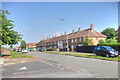
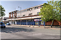


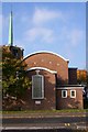
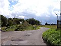
26 photos from this area
Area Information
Key information about the L24 2TD including its size, population, and administrative classification.
- Area Type
- Postcode
- Area Size
- 5752 m²
- Population
- 1470
- Population Density
- 5149 people/km²
House Prices in L24 2TD
18
Properties
£109,699
Average Sold Price
£79,000
Lowest Price
£130,000
Highest Price
Showing 18 properties
| Address | Type | Beds | Baths | Last Sale Price | Last Sale Date | |
|---|---|---|---|---|---|---|
| 162 Eastern Avenue, Liverpool, L24 2TD | Terraced | 2 | 1 | £129,500 | Jul 2024 | |
| 134 Eastern Avenue, Liverpool, L24 2TD | house | - | - | £110,000 | Mar 2023 | |
| 128 Eastern Avenue, Liverpool, L24 2TD | house | 3 | 2 | £130,000 | Oct 2020 | |
| 158 Eastern Avenue, Liverpool, L24 2TD | house | 3 | - | £99,995 | Oct 2011 | |
| 152 Eastern Avenue, Liverpool, L24 2TD | house | - | - | £79,000 | Jan 2005 | |
| 136 Eastern Avenue, Liverpool, L24 2TD | house | - | - | - | - | |
| 144 Eastern Avenue, Liverpool, L24 2TD | house | - | - | - | - | |
| 154 Eastern Avenue, Liverpool, L24 2TD | house | - | - | - | - | |
| 132 Eastern Avenue, Liverpool, L24 2TD | Terraced | - | - | - | - | |
| 140 Eastern Avenue, Liverpool, L24 2TD | Terraced | - | - | - | - |
Page 1 of 2
Energy Efficiency in L24 2TD
Amenities
Schools
| Rank | School | Type | Entry gender | Ages |
|---|
Explore more schools in this area
Go to Schools tabDemographics
Household Size
Family (3-5 people)
most common
Accommodation Type
Houses
most common
Tenure
38
majority
Ethnic Group
White
most common
Religion
N/A
most common
Household Composition
N/A
most common
Age
47
median
Adults (30-64 years)
most common
Household Deprivation
N/A
with no deprivation
NS-SEC
15
in Lower managerial occupations
Explore more demographic insights in this area
Go to Demographics tabPlanning
Planning Constraints
- Flood RiskPremium
- Ramsar Wetland SitesPremium
- Area of Outstanding Natural BeautyPremium
- Protected Nature ReservePremium
- Protected WoodlandPremium