Area Overview for L21 5LE
Photos of L21 5LE


Area Information
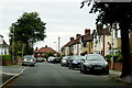
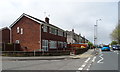
Living in L21 5LE means being part of a small, tightly knit residential cluster in England, where the population of 1509 reflects a community centred around family homes and stable households. The area’s character is defined by its proximity to key transport routes and amenities, making it practical for daily life. With a median age of 47 and a population skewed towards adults aged 30–64, the neighbourhood has a mature, settled feel. Home ownership is high at 83%, with most properties being houses rather than flats, suggesting a preference for traditional living. Safety is a strong point, with a crime risk score of 81 and no significant environmental hazards. Residents benefit from excellent broadband connectivity and access to rail and ferry services, ensuring both convenience and connectivity. The area’s compact size means amenities are within practical reach, from retail outlets to transport hubs, creating a self-contained yet accessible environment for those prioritising stability and ease of movement.
- Area Type
- Postcode
- Area Size
- Not available
- Population
- 1509
- Population Density
- 6343 people/km²
The property market in L21 5LE is dominated by owner-occupied homes, with 83% of residents living in properties they own. This high rate of home ownership suggests a community that values long-term investment and stability. The accommodation type is primarily houses, which contrasts with areas where flats or apartments predominate. This housing stock is likely to appeal to families or individuals seeking spacious, traditional homes. However, the area’s small size means the housing stock is limited, and buyers may find the market competitive. The proximity to rail and ferry services adds to the area’s appeal, particularly for those needing easy access to commuting routes. For buyers, the combination of high home ownership and a focus on single-family homes indicates a market where properties are likely to hold value, though the small footprint of the area may restrict options for those seeking a wider selection of properties.
House Prices in L21 5LE
No properties found in this postcode.
Energy Efficiency in L21 5LE
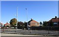
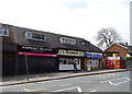
Life in L21 5LE is shaped by its proximity to essential amenities, including retail outlets, transport hubs, and ferry services. Nearby shops such as Tesco Sefton, Asda Bootle, and Tesco Litherland provide convenient access to groceries and daily necessities. The area’s rail stations, including Seaforth & Litherland and Aintree, offer easy connections to broader networks, while ferry terminals like Liverpool Belfast and Seacombe provide links to nearby cities and islands. Though the data does not mention parks or leisure facilities, the presence of multiple retail and transport options suggests a practical, service-oriented lifestyle. The compact nature of the area means residents can access these amenities without long commutes, fostering a sense of convenience. Whether for shopping, commuting, or travel, the infrastructure supports a balanced daily routine, making L21 5LE suitable for those prioritising accessibility and efficiency.
Amenities
Schools
| Rank | School | Type | Entry gender | Ages |
|---|
Explore more schools in this area
Go to Schools tabDemographics
The community in L21 5LE is predominantly composed of adults aged 30–64, with a median age of 47. This suggests a population that is largely in their prime working and family-raising years, contributing to a stable, established local economy. Home ownership is exceptionally high at 83%, indicating a strong preference for long-term residency over rental properties. The accommodation type is overwhelmingly houses, which aligns with the area’s traditional, residential character. The predominant ethnic group is White, reflecting a homogenous demographic profile. While no specific data on deprivation is provided, the high home ownership and low crime risk suggest a quality of life that is generally secure and predictable. The absence of significant planning constraints or environmental risks further reinforces this sense of stability, making L21 5LE an appealing choice for those seeking a settled, low-maintenance lifestyle.
Household Size
Accommodation Type
Tenure
Ethnic Group
Religion
Household Composition
Age
Household Deprivation
NS-SEC
Explore more demographic insights in this area
Go to Demographics tabPlanning
Planning Constraints
- Flood RiskPremium
- Ramsar Wetland SitesPremium
- Area of Outstanding Natural BeautyPremium
- Protected Nature ReservePremium
- Protected WoodlandPremium