Area Overview for L2 7PY
Photos of L2 7PY


Area Information
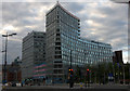
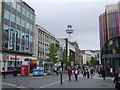
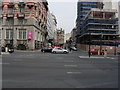
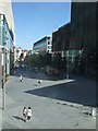
Living in L2 7PY means being part of a small, tightly knit residential cluster in England, home to just 1,119 people. This area is defined by its proximity to Liverpool’s urban core, with easy access to rail, ferry, and retail hubs. The community is young, with a median age of 22 and the majority of residents aged 15–29. Daily life here is shaped by the surrounding infrastructure: five rail stations, including Liverpool James Street and Moorfields, offer frequent connections to the city. Retailers like Sainsburys and Tesco are within practical reach, while ferry terminals at Pier Head and Woodside Birkenhead provide links to nearby towns and islands. The area’s compact size means residents can navigate its amenities on foot or by bike. While the housing stock is limited to flats, the low flood risk and absence of environmental constraints make it a practical choice for those prioritising convenience over expansive green spaces. However, the high crime risk is a notable concern for prospective buyers.
- Area Type
- Postcode
- Area Size
- Not available
- Population
- 1119
- Population Density
- 6159 people/km²
The property market in L2 7PY is characterised by a high rental demand and limited ownership. With only 15% of properties owned by residents, the area functions primarily as a rental market, catering to students and young professionals. The accommodation type is exclusively flats, which aligns with the needs of transient or budget-conscious buyers. This small area’s housing stock is constrained, meaning availability is limited, and prices may be influenced by proximity to transport links and amenities. For buyers, the challenge lies in securing a property in a market where ownership is rare, and the small size of the area means competition for available units. The prevalence of flats may also limit options for those seeking larger homes or long-term investment.
House Prices in L2 7PY
No properties found in this postcode.
Energy Efficiency in L2 7PY
Residents of L2 7PY have access to a range of urban amenities within easy reach. Five rail stations, including Liverpool Central Loop Line, provide efficient connections to the city, while ferry terminals like Liverpool Pier Head and Woodside Birkenhead offer links to the Isle of Man and Birkenhead. Retail options are plentiful, with Sainsburys and Tesco stores nearby, catering to everyday shopping needs. The area’s proximity to transport hubs and retail centres supports a convenient, fast-paced lifestyle. While there is no mention of parks or leisure facilities in the data, the presence of multiple rail and ferry services suggests a focus on connectivity over green spaces. This makes L2 7PY ideal for those prioritising accessibility to urban amenities over expansive natural environments.
Amenities
Schools
| Rank | School | Type | Entry gender | Ages |
|---|
Explore more schools in this area
Go to Schools tabDemographics
The population of L2 7PY is overwhelmingly young, with a median age of 22 and 85% of residents falling within the 15–29 age range. This demographic profile suggests a community dominated by students, recent graduates, and young professionals. Home ownership is low, with just 15% of properties owned by residents, indicating a rental-heavy market. The accommodation type is exclusively flats, reflecting the area’s compact nature and likely appeal to those seeking short-term or flexible housing. The predominant ethnic group is White, though specific data on diversity beyond this is not provided. The high proportion of young adults may influence local amenities, with services tailored to their needs. However, the low home ownership rate and limited housing stock could affect long-term stability for those seeking to settle permanently.
Household Size
Accommodation Type
Tenure
Ethnic Group
Religion
Household Composition
Age
Household Deprivation
NS-SEC
Explore more demographic insights in this area
Go to Demographics tabPlanning
Planning Constraints
- Flood RiskPremium
- Ramsar Wetland SitesPremium
- Area of Outstanding Natural BeautyPremium
- Protected Nature ReservePremium
- Protected WoodlandPremium