Area Overview for L15 8FL
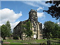
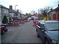
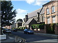
Photos of L15 8FL


Area Information
Living in L15 8FL offers a compact, residential experience shaped by its small population of 1,525 and the quiet character of its cluster of homes. This area is defined by its proximity to key transport links and a mix of local amenities that cater to daily needs. The community here is predominantly middle-aged, with a median age of 47 and a strong presence of adults aged 30–64. Most residents own their homes, with 62% of properties in private ownership, reflecting a stable, long-term demographic. The area’s small size means it is likely to feel close-knit, though its immediate surroundings offer access to broader networks of retail, transport, and leisure. With excellent broadband connectivity and a low crime score of 76, it balances practicality with a sense of security. For those prioritising convenience, L15 8FL’s position near rail lines, ferry terminals, and airports makes it a strategic choice for commuters or those needing regular travel. The absence of environmental constraints like protected woodlands or AONB designations means development is unrestricted, though the area’s charm lies in its simplicity and functional layout.
- Area Type
- Postcode
- Area Size
- Not available
- Population
- 1525
- Population Density
- 5347 people/km²
The property market in L15 8FL is characterised by a high rate of home ownership (62%) and a predominance of houses. This suggests a market skewed towards owner-occupied properties rather than rental units, which may influence availability and pricing dynamics. With only 1,525 residents in a small postcode area, the housing stock is likely limited, meaning buyers may need to consider nearby regions for more options. The focus on houses implies a preference for larger, family-friendly homes, though the exact size or age of properties is not specified. For those seeking to purchase within L15 8FL, the compact nature of the area could mean competition for available listings. However, the absence of planning constraints like protected woodlands or AONB designations may make development or renovation more straightforward. Buyers should also consider the area’s proximity to transport links, which could enhance its appeal for commuters or those requiring regular travel.
House Prices in L15 8FL
No properties found in this postcode.
Energy Efficiency in L15 8FL
L15 8FL’s lifestyle is shaped by its proximity to a range of essential amenities. Retail options include major supermarkets like Tesco Clocktower, Morrisons Daily, and Asda Penny, ensuring everyday shopping needs are met locally. The area’s rail stations—Wavertree Technology Park, Broad Green, and Edge Hill—provide access to public transport, while nearby ferry terminals, such as Liverpool Pier Head and Woodside Birkenhead, offer connections to surrounding regions. For air travel, Liverpool John Lennon Airport is within reach, making it easy to travel further afield. The presence of multiple transport options enhances convenience, whether for commuting, leisure, or business. While the area itself is small, its strategic location means residents can access larger urban hubs with ease. The combination of retail, transport, and travel infrastructure creates a practical, accessible lifestyle, ideal for those who value connectivity without sacrificing the quietude of a residential setting.
Amenities
Schools
| Rank | School | Type | Entry gender | Ages |
|---|
Explore more schools in this area
Go to Schools tabDemographics
The community in L15 8FL is predominantly composed of adults aged 30–64, with a median age of 47. This suggests a mature population, likely with established careers and family structures. Home ownership is strong, with 62% of residents living in properties they own, compared to 38% renting. The accommodation type is primarily houses, indicating a residential area with more spacious, traditional housing stock. The predominant ethnic group is White, reflecting a homogeneous demographic profile. While no specific data on deprivation is provided, the high home ownership rate and age distribution suggest a community with financial stability and long-term residency. The absence of detailed diversity metrics means the area’s cultural composition is not extensively documented, but the data points to a settled, middle-aged population with a focus on homeownership. This profile may appeal to buyers seeking a stable, low-maintenance environment with minimal turnover.
Household Size
Accommodation Type
Tenure
Ethnic Group
Religion
Household Composition
Age
Household Deprivation
NS-SEC
Explore more demographic insights in this area
Go to Demographics tabPlanning
Planning Constraints
- Flood RiskPremium
- Ramsar Wetland SitesPremium
- Area of Outstanding Natural BeautyPremium
- Protected Nature ReservePremium
- Protected WoodlandPremium