Area Overview for L15 1GA
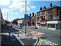
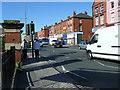
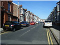
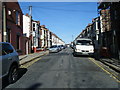
Photos of L15 1GA


Area Information
Living in L15 1GA means being part of a compact residential cluster in England, home to 1,576 people. This small area is characterised by its mix of practicality and accessibility, with residents enjoying proximity to key transport links and retail hubs. The community is predominantly composed of adults aged 30–64, reflecting a mature demographic with established routines. Daily life here balances suburban comfort with urban convenience, with easy access to rail networks, ferry terminals, and major supermarkets. The area’s broadband score of 100 ensures seamless digital connectivity, while mobile coverage scores at 85, offering reliable communication. Though modest in size, L15 1GA provides a functional base for those prioritising accessibility over sprawling landscapes, with homes primarily in single-family structures. Its appeal lies in simplicity: a place where essentials are within reach, and the pace of life remains steady.
- Area Type
- Postcode
- Area Size
- Not available
- Population
- 1576
- Population Density
- 14446 people/km²
The property market in L15 1GA is shaped by a low home ownership rate of 22%, suggesting that most properties are rented rather than owned. This indicates a rental-focused market, likely influenced by the area’s compact size and practical amenities. The predominant accommodation type is houses, which are typically larger and more private than flats, appealing to families or individuals seeking space. However, the limited number of homes and low ownership rate may create competition among buyers, particularly for those seeking owner-occupied properties. The small area’s immediate surroundings likely offer limited housing stock, meaning buyers must consider proximity to nearby towns or transport links. For those prioritising rental flexibility, L15 1GA’s market may be advantageous, but for homeowners, the scarcity of available properties could pose challenges.
House Prices in L15 1GA
No properties found in this postcode.
Energy Efficiency in L15 1GA
Life in L15 1GA is supported by a range of nearby amenities, including five retail outlets such as Co-op Lawrence, Aldi Wavertree, and Asda Sefton, ensuring everyday shopping needs are met. The area’s rail network, with stations like Mossley Hill and Wavertree Technology Park, provides easy access to urban centres and employment opportunities. Ferry terminals, including Liverpool Pier Head and Woodside Birkenhead, offer scenic routes to nearby destinations, adding to the area’s appeal for commuters and leisure travellers. While the data does not specify parks or leisure facilities, the proximity to rail and ferry services suggests a lifestyle centred on connectivity and convenience. Residents can enjoy a mix of practical retail, efficient transport, and regional travel options, making daily life both functional and accessible.
Amenities
Schools
| Rank | School | Type | Entry gender | Ages |
|---|
Explore more schools in this area
Go to Schools tabDemographics
The population of L15 1GA is 1,576, with a median age of 47, indicating a community skewed towards middle-aged adults. The most common age range is 30–64 years, suggesting a stable, established population. Home ownership here is relatively low at 22%, implying that a significant proportion of residents rent their homes. The primary accommodation type is houses, reflecting a preference for standalone properties over flats. The predominant ethnic group is White, though no specific data on diversity or deprivation is provided. This demographic profile suggests a community focused on long-term stability, with a workforce likely rooted in local industries or commuting to nearby urban centres. The age distribution and ownership rates indicate a balance between older residents and younger families, though the absence of detailed diversity metrics limits deeper analysis of social composition.
Household Size
Accommodation Type
Tenure
Ethnic Group
Religion
Household Composition
Age
Household Deprivation
NS-SEC
Explore more demographic insights in this area
Go to Demographics tabPlanning
Planning Constraints
- Flood RiskPremium
- Ramsar Wetland SitesPremium
- Area of Outstanding Natural BeautyPremium
- Protected Nature ReservePremium
- Protected WoodlandPremium