Area Overview for L11 9DJ
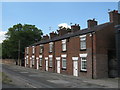
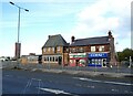
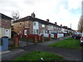
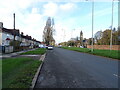
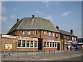
Photos of L11 9DJ


Area Information
Living in L11 9DJ means inhabiting a compact, residential postcode area in England that blends proximity to essential services with a tightly knit community. Covering just 5.4 hectares, this small cluster accommodates 1,903 residents, resulting in a high population density of 35,114 people per square kilometre. The area’s size suggests a focus on established housing rather than sprawling development, with homes predominantly in the form of houses. Daily life here is shaped by its location, offering easy access to nearby schools, rail networks, and ferry terminals. The presence of two primary schools and multiple rail stations within practical reach makes it appealing for families and commuters. While the area lacks large-scale amenities, its density ensures that basic needs are met within short distances. Residents benefit from excellent broadband connectivity, scoring 92 out of 100, which supports both work and leisure. However, the medium crime risk score of 44 means standard security measures are advisable. L11 9DJ is a pragmatic choice for those prioritising convenience over expansive space, with a community profile skewed towards adults aged 30–64.
- Area Type
- Postcode
- Area Size
- 5.4 hectares
- Population
- 1903
- Population Density
- 2133 people/km²
The property market in L11 9DJ is characterised by a low home ownership rate of 32%, suggesting that the area is more rental-oriented than owner-occupied. The predominant accommodation type is houses, which may indicate a mix of older, established properties rather than modern developments. Given the small area size of 5.4 hectares, the housing stock is likely limited, with little scope for new builds. This could mean that buyers face competition for a small number of available properties, particularly if demand is driven by proximity to nearby schools and transport links. The area’s compact nature may also mean that properties are closely spaced, potentially limiting privacy or garden space. For those considering purchase, the rental market’s dominance could signal a transient population, which may influence property values and long-term investment potential. Buyers should also consider the area’s density, which may impact living conditions for those preferring more space.
House Prices in L11 9DJ
Showing 1 properties
| Address | Type | Beds | Baths | Last Sale Price | Last Sale Date | |
|---|---|---|---|---|---|---|
| 200 Stonedale Crescent, Liverpool, L11 9DJ | hospital_care_home | - | - | £597,703 | Aug 2017 |
Energy Efficiency in L11 9DJ
Residents of L11 9DJ enjoy a range of nearby amenities that cater to daily needs. The area’s retail offerings include Iceland Stonedale, Spar, and Farmfoods Croxteth, providing access to grocery shopping and convenience stores. While no specific dining or leisure venues are listed, the proximity to rail stations and ferry terminals suggests opportunities for socialising in nearby towns. The rail network connects to Fazakerley, Rice Lane, and Orrell Park stations, enabling easy travel to larger centres for entertainment or shopping. Ferry services link to Liverpool’s major terminals, offering travel to Belfast, the Isle of Man, and Dublin. These transport options enhance the area’s appeal, allowing residents to access broader facilities without relying on a car. The compact nature of L11 9DJ means that amenities are closely clustered, though the lack of detailed information on parks or leisure spots leaves room for further exploration of local recreational opportunities.
Amenities
Schools
Residents of L11 9DJ have access to two primary schools: Croxteth Community Comprehensive School and Stonebridge Lane County Primary School. Both institutions serve the local community, though no Ofsted ratings are provided in the data. The presence of two primary schools within the area suggests that families with young children have nearby options, reducing the need for long commutes. However, the absence of secondary schools or specialist provisions means that parents may need to look beyond the immediate postcode for comprehensive education. The mix of primary schools could indicate a focus on early education, but the lack of diversity in school types may limit choices for older students. For families prioritising proximity to schools, L11 9DJ’s offerings are a practical advantage, though further research into school performance would be necessary for a complete picture.
| Rank | School | Type | Entry gender | Ages |
|---|
Explore more schools in this area
Go to Schools tabDemographics
The demographic profile of L11 9DJ reflects a mature, stable population. The median age is 47, with the majority of residents falling within the 30–64 age range. This suggests a community of established professionals and families, rather than students or retirees. Home ownership rates are relatively low at 32%, indicating a rental market that may cater to transient or younger households. The predominant accommodation type is houses, which aligns with the area’s compact layout and residential focus. The predominant ethnic group is White, though no specific data on diversity or deprivation levels is provided. The high population density—35,114 people per square kilometre—raises questions about housing pressures, though the small area size limits expansion. For buyers, this demographic suggests a market where demand may be driven by proximity to schools and transport, rather than long-term residency. The age profile also implies a need for community amenities that cater to middle-aged adults, such as accessible healthcare and leisure facilities.
Household Size
Accommodation Type
Tenure
Ethnic Group
Religion
Household Composition
Age
Household Deprivation
NS-SEC
Explore more demographic insights in this area
Go to Demographics tabPlanning
Planning Constraints
- Flood RiskPremium
- Ramsar Wetland SitesPremium
- Area of Outstanding Natural BeautyPremium
- Protected Nature ReservePremium
- Protected WoodlandPremium