Area Overview for L1 6EF
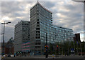
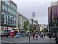
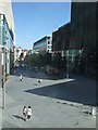
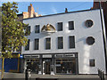
Photos of L1 6EF


Area Information
Living in L1 6EF means being part of a small, tightly knit residential cluster in England with a population of 2,478. This area is defined by its compact size and proximity to key transport routes, making it a practical choice for those prioritising connectivity. The community is young, with most residents aged between 15 and 29, reflecting a dynamic demographic that shapes local culture and amenities. Daily life here is centred around nearby retail hubs, railway stations, and ferry terminals, which provide easy access to shopping, commuting, and travel. While the area lacks natural landscapes or protected sites, its strategic location near Liverpool’s central rail network and waterfront terminals offers convenience for both work and leisure. However, residents should be aware of the high crime risk, which requires attention to personal security. Despite this, L1 6EF’s small scale and accessibility make it a viable option for those seeking a compact, connected living environment.
- Area Type
- Postcode
- Area Size
- Not available
- Population
- 2478
- Population Density
- 6665 people/km²
The property market in L1 6EF is characterised by a low rate of home ownership, with only 14% of residents owning their homes. This suggests that the area is primarily a rental market, catering to tenants rather than buyers. The accommodation type is predominantly flats, which are well-suited to the area’s small scale and the needs of its young, transient population. For buyers, this means limited opportunities for owner-occupied properties, with most available housing likely to be rental units. The focus on flats also implies a lack of larger family homes or detached properties, which may not align with long-term residential goals. Prospective buyers should consider whether the rental market’s dynamics and the limited housing stock meet their needs, particularly if they are seeking a property to hold or invest in.
House Prices in L1 6EF
Showing 1 properties
| Address | Type | Beds | Baths | Last Sale Price | Last Sale Date | |
|---|---|---|---|---|---|---|
| 46 Whitechapel, Liverpool, L1 6EF | shop | - | - | - | - |
Energy Efficiency in L1 6EF
Residents of L1 6EF have access to a range of nearby amenities that support daily life. The retail sector includes major stores such as Tesco Liverpool, Iceland Williamson, and Tesco Clayton, providing convenience for shopping and groceries. Rail services are extensive, with stations like Liverpool Lime Street Low Level and Moorfields Railway Station offering direct links to employment hubs and leisure destinations. Ferry terminals, including Liverpool Pier Head and Woodside Birkenhead, enable quick travel to the Isle of Man, Dublin, and surrounding areas. These amenities contribute to a lifestyle that balances practicality with connectivity, allowing residents to commute efficiently or explore beyond the area. While the absence of parks or green spaces may limit outdoor leisure options, the proximity to transport and retail ensures a functional, urban-oriented living experience.
Amenities
Schools
| Rank | School | Type | Entry gender | Ages |
|---|
Explore more schools in this area
Go to Schools tabDemographics
The population of L1 6EF is overwhelmingly young, with a median age of 22 and the majority of residents falling within the 15-29 age range. This demographic profile suggests a community shaped by students, early-career professionals, and young families. Home ownership is relatively low at 14%, indicating that most residents rent their accommodation. The predominant housing type is flats, which aligns with the area’s compact nature and the needs of younger occupants. The predominant ethnic group is White, though specific data on diversity beyond this is not provided. The low home ownership rate and high proportion of young adults may influence local services and amenities, which are tailored to transient or mobile populations. This profile also means the area is likely to have a fast-paced, evolving character, with demand for short-term or flexible housing options.
Household Size
Accommodation Type
Tenure
Ethnic Group
Religion
Household Composition
Age
Household Deprivation
NS-SEC
Explore more demographic insights in this area
Go to Demographics tabPlanning
Planning Constraints
- Flood RiskPremium
- Ramsar Wetland SitesPremium
- Area of Outstanding Natural BeautyPremium
- Protected Nature ReservePremium
- Protected WoodlandPremium