Area Overview for Ince
Photos of Ince

Area Information
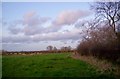
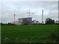
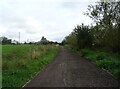
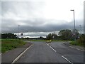
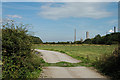
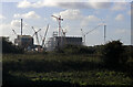
Ince is a small civil parish situated just three square kilometres in size. It lies in the unitary authority of Cheshire West and Chester, positioned immediately east of the Stanlow Oil Refinery. The village occupies a low ridge within the marshlands surrounding the rivers Gowy and Mersey. Its distinctive character stems from a deep historical foundation; first recorded in the Domesday Book as *Inise*, the name reflects its original position as an island in the wetlands. The settlement existed as a civil parish between 1866 and 1950 before merging into Ellesmere Port and re-establishing with smaller boundaries in 1987. Today, the 2011 census recorded a population of 203, indicating a very low-density residential environment. You will find remnants of Ince Manor, a 13th-century monastic grange and Grade I listed building, alongside the ancient parish church of St James. The area also shares an Ince & Elton railway station with its neighbour, Elton. Daily life here is influenced by proximity to major industrial sites, including the nearby Peel Group's Ince Park, which hosts a biomass power station and waste-to-energy facility. While the village retains historical significance and rural charm, its location borders active industrial zones, creating a unique boundary between heritage sites and modern energy infrastructure.
- Area Type
- District Borough Unitary Ward
- Area Size
- 3.7 km²
- Population
- Not available
- Population Density
- Not available
Demographics
The community profile of Ince reflects a settlement with a mature population structure. The median age sits at 70 years, which is significantly higher than the national average. Most residents fall into older age brackets, a fact consistent with the overall age distribution. This demographic skew suggests the area attracts retirees or those seeking a quiet, less fast-paced environment. Home ownership is a defining feature of daily life in the parish, with 60 per cent of households owning their residences outright. This high rate of ownership indicates strong stability and a sense of long-term settlement within the community. The remaining households likely comprise a mix of social housing and shared ownership, though specific breakdowns are not detailed in available records. The small population size of roughly 200 people creates a close-knit atmosphere where residents know one another personally. Because the area is so small, communal interactions likely occur frequently at local landmarks such as St James' Church. You should expect a demographic landscape dominated by older generations, with fewer families with young children compared to larger suburban towns. The absence of significant youth population may limit local activities geared toward younger age groups.
Household Size
Accommodation Type
Tenure
Ethnic Group
Religion
Household Composition
Age
Household Deprivation
NS-SEC
Explore more demographic insights in this area
Go to Demographics tabPlanning
Planning Constraints
- Flood RiskLocked
- Ramsar Wetland SitesLocked
- Area of Outstanding Natural BeautyLocked
- Protected Nature ReserveLocked
- Protected WoodlandLocked
- Crime RiskLocked