Area Overview for Guilden Sutton
Photos of Guilden Sutton


Area Information
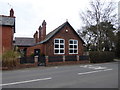
Guilden Sutton is a civil parish and village located in the unitary authority of Cheshire West and Chester. It sits approximately three miles east of Chester within gently rolling countryside. The area consists of around 630 properties and covers a total area of 43.3 hectares. Despite having grown substantially over the last century, it remains designated as a village rather than a built-up town. The name likely originates from Old English meaning golden south farm or settlement, referencing its position at the southern extremity of Wilaveston Hundred. Historical records show the settlement was mentioned in the Domesday Book as Sudtone under the Bishop of Chester. Archaeological finds from the site include a Roman bronze coin of Licinius I, discovered behind the Bird in Hand pub. The community features a church, primary school, post office, pub, and village hall. You will find the area is entirely within the Green Belt, meaning new construction faces strict limitations. The population grew from 442 in 1951 to roughly 1660 to 1700 inhabitants by the early 2000s. This growth came from boundary changes such as the inclusion of Hoole in the 1950s and residential developments like the Oaklands estate. Living in Guilden Sutton offers access to these historical landmarks alongside modern rural convenience.
- Area Type
- Built Up Area 250
- Area Size
- 43.3 hectares
- Population
- Not available
- Population Density
- Not available
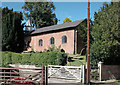
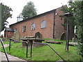
Residents of Guilden Sutton have several shops and services within practical reach. For retail needs, you can visit Spar, Asda Gowy, and the Co-op Kingsway. These venues provide daily essentials without requiring a long drive into the city of Chester. The village also has transport links accessible from nearby stations such as Chester Railway Station, Bache Railway Station, and Mouldsworth Railway Station. The closest amenities include a pub known as the Bird in Hand, which has been in its present form since 1844. You will also find the Bird in Hand pub mentioned alongside other local businesses that keep the village functional. The area includes a post office and a church hall built in 1916 for community use. Dining options are centred around the pub and local businesses. The presence of these named venues like Spar and Asda Gowy confirms that the village has self-sufficiency. Living here offers the convenience of named retail partners and established social spots while maintaining the feel of a rural settlement.
Amenities
Schools
Education facilities in Guilden Sutton are anchored by Guilden Sutton CofE Primary School. This institution holds an outstanding Ofsted rating, which is the highest grading possible. The school serves the local community of children in the village. The presence of a primary school in the village centre supports families settled in the 630 properties that make up the area. The data does not list any secondary schools immediately adjacent to the village, which is typical for villages of this scale in Cheshire. Children in Guilden Sutton generally feed into this local primary provision before moving to larger secondary institutions in nearby towns like Chester. The single outstanding-rated primary school offers a clear and trusted educational starting point for local families. If you are considering moving to Guilden Sutton for the sake of your children, this specific school rating is the primary factor mentioned in the available data. The school's location within the village also ensures that daily schooling trips remain contained within the local neighbourhood boundaries.
| Rank | School | Type | Entry gender | Ages |
|---|
Explore more schools in this area
Go to Schools tabDemographics
The community profile of Guilden Sutton shows a distinct age distribution with a median age of 70. The most common age range listed in the census data is marked as Age: Total, indicating a need to examine the full age band breakdown for precise cohorts. Home ownership stands at a very high level of 85% within the area. This high rate suggests the village is predominantly settled rather than transient. Household composition and accommodation type data are listed in the provided records but do not specify the exact number of single-person homes or families with children. The predominant ethnic group and religion data are available in the raw files but are not detailed in the summary text. This high ownership rate often correlates with long-term residents who value the quiet, rural character of the Green Belt village. The demographic picture points to a stable population where people have lived for generations. With a median age this high, the village may cater particularly well to retirees or those seeking a slower pace of life. The lack of specific single-unit data highlights that the community is built around established families and owners rather than rental tenants.