Area Overview for Gregson Lane
Photos of Gregson Lane
Area Information
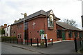
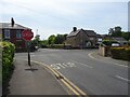
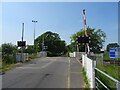
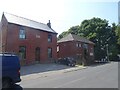
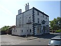
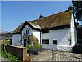
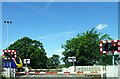
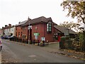
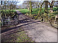
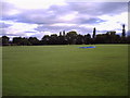
Gregson Lane functions as a distinct rural village community within Lancashire, England, situated approximately four miles from Preston city centre. This built-up area spans 67.6 hectares and forms part of the North West Region. While Royal Mail designates the location within the Hoghton postal district, local authorities categorise the majority of the village inside the unparished area of South Ribble borough, with a smaller section falling under Brindle civil parish. The village maintains a strong local identity separate from its postal label, hosting independent institutions like a folk club established in 1988 and a newly refurbished community centre completed in 2023. Life here feels rooted in history, anchored by Grade II* listed Arrowsmith House, where St Edmund Arrowsmith ministered before his arrest in 1628. Residents benefit from a convenient location that connects the village to neighbours like Bamber Bridge, Higher Walton, Coupe Green, and Brindle. Daily life revolves around the village centre, which features two public houses including The Black Horse. The setting offers a blend of residential quietude and community engagement without the noise of a larger urban centre. You will find homes in Gregson Lane surrounded by green space yet kept within easy reach of essential services and transport links that lead directly to Greater Manchester and Liverpool.
- Area Type
- Built Up Area 250
- Area Size
- 67.6 hectares
- Population
- Not available
- Population Density
- Not available
Your daily lifestyle in Gregson Lane centres on local amenities and public houses that support village life. Two public houses anchor the social scene: Nets Bar, formerly known as Gregson Lane Sports and Social Club, and The Black Horse. These venues serve as community hubs where residents gather for meals, drinks, and social events. The village's retail needs are met by five shops within practical reach, including Spar locations and Morrisons Daily Clayton. These stores provide essentials without requiring a trip to larger towns. Transport links enhance your ability to visit nearby attractions and run errands. Five railway stations are located near Gregson Lane, including Bamber Bridge, Lostock Hall, and Pleasington. Other nearby amenities include leisure facilities in the wider South Ribble area. The village also features All Saints Church in Higher Walton and Bank Head Farmhouse as nearby points of interest. Arrowsmith House stands as a Grade II* listed building, adding historical character to your surroundings. You will also find the reconstructed community centre, finished in 2023, offering space for local groups and events. This blend of historic sites, local pubs, and accessible transport creates a functional lifestyle where you can enjoy village comforts while remaining connected to roads leading to Bamber Bridge, Higher Walton, and Preston.
Amenities
Schools
Families considering schools near Gregson Lane have specific options within walking distance or a very short drive. The primary education phase is supported by Brindle Gregson Lane Primary School, which serves the immediate local catchment area. For parents seeking a Catholic education, St Joseph's Catholic Primary School in Brindle offers good Ofsted ratings, providing a faith-based option with verified quality standards. These two institutions represent the core primary education provision for the village community. The mix of schools suggests that most children living in Gregson Lane will attend these primary establishments before potentially moving to secondary schools further away, as no secondary schools are listed in the immediate vicinity data. The presence of St Joseph's with its good rating offers reassurance regarding educational standards within the Brindle area. Educators and families in Gregson Lane can rely on these specific institutions for the early years of schooling. The availability of these named schools indicates a structured local education network rather than reliance on distant catchment areas for younger pupils. Parents should verify current catchment boundaries during the application process, as school admission criteria can change.
| Rank | School | Type | Entry gender | Ages |
|---|
Explore more schools in this area
Go to Schools tabDemographics
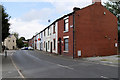
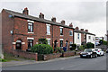
The people living in Gregson Lane present a clear demographic picture defined by age and stability. The median age for residents sits at 70 years, with the most common age range covering the total population. This figure suggests a community dominated by older adults, likely reflecting the village's nature as a retirement spot or a place for established families to grow older. Studies of similar rural areas often show that higher median ages correlate with fewer young school-age children and more empty nesters. Home ownership is the defining characteristic of the local population. An impressive 87% of households in Gregson Lane own their homes outright or with a mortgage. This high level of ownership indicates deep community roots and financial stability among residents. You are unlikely to encounter significant transient populations or student housing blocks. The household composition data reflects a total count without specific age-breakdown splits, but the median age confirms that the area is not characterised by a youthful workforce or large families with young children moving frequently. The predominance of owner-occupied stock shapes a quiet, settled atmosphere where neighbours know each other well, fostering a tight-knit environment typical of Lancashire villages.
Household Size
Accommodation Type
Tenure
Ethnic Group
Religion
Household Composition
Age
Household Deprivation
NS-SEC
Explore more demographic insights in this area
Go to Demographics tabPlanning
Planning Constraints
- Crime RiskPremium