Area Overview for Grassendale & Cressington Ward
Photos of Grassendale & Cressington Ward


Area Information
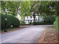
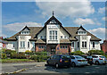
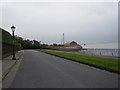
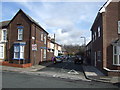
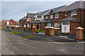
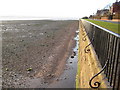
Grassendale and Cressington Ward covers 2.0 km² and sits approximately 4 miles east of Liverpool city centre within the North West English Region. The area comprises two interconnected Victorian residential developments that emerged as private speculative ventures during the first half of the 19th century. Grassendale commenced construction in 1845, followed by Cressington in 1846, establishing them as the second and third gated riverside housing developments in Aigburth. Both estates originally catered to wealthy Liverpool merchants known as the "carriage folk," who possessed the means to commute between their homes and the city centre. Today, living in Grassendale and Cressington Ward offers access to a private riverside promenade along the River Mersey and a secluded character defined by 19th-century gated private estates. The neighbourhood retains its historical exclusivity through restricted access and elegant architecture, distinguishing it from typical urban districts. Residents enjoy a peaceful atmosphere created by generous mature planting and carefully maintained Victorian mansions set within large gardens. The area was officially designated as a Conservation Area in 1968, ensuring strict planning controls to preserve its distinctive architectural character. This heritage protection maintains the visual unity and grace that have defined the development since its inception.
- Area Type
- District Borough Unitary Ward
- Area Size
- 2.0 km²
- Population
- Not available
- Population Density
- Not available
Demographics
The community profile in Grassendale and Cressington Ward reflects a settled, older demographic with a median age of 70. This older population aligns with the history of the area as an enclave for established families and institutional age groups. Home ownership stands at 81%, indicating a predominantly owner-occupied market where residents have long-term stakes in their properties. The high ownership rate suggests stability within the neighbourhood, contrasting with areas dominated by short-term tenancies. Household composition and accommodation types remain data points defining the local structure, though specific distribution figures are not detailed in the current dataset. The area does not report specific data regarding predominant ethnic groups or religious affiliations, yet the historical context of serving wealthy merchants suggests a traditionally homogenous community that has evolved over centuries. Crime risk assessments indicate a Pass level with a safety score of 80 out of 100, confirming below-average crime rates and a safer environment for residents. This low crime environment complements the quiet, private nature of the gated estates. The demographic profile supports a lifestyle centred on stability, comfort, and the preservation of the unique Victorian aesthetic found throughout the ward.
Household Size
Accommodation Type
Tenure
Ethnic Group
Religion
Household Composition
Age
Household Deprivation
NS-SEC
Explore more demographic insights in this area
Go to Demographics tabPlanning
Planning Constraints
- Flood RiskPremium
- Ramsar Wetland SitesPremium
- Area of Outstanding Natural BeautyPremium
- Protected Nature ReservePremium
- Protected WoodlandPremium
- Crime RiskPremium