Area Overview for FY5 1HN
Photos of FY5 1HN

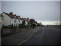


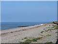

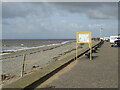
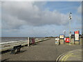
38 photos from this area
Area Information
Key information about the FY5 1HN including its size, population, and administrative classification.
- Area Type
- Postcode
- Area Size
- 1.3 hectares
- Population
- 1312
- Population Density
- 4145 people/km²
House Prices in FY5 1HN
29
Properties
£124,593
Average Sold Price
£21,500
Lowest Price
£217,500
Highest Price
Showing 29 properties
| Address | Type | Beds | Baths | Last Sale Price | Last Sale Date | |
|---|---|---|---|---|---|---|
| 24 Westbourne Road, Thornton Cleveleys, FY5 1HN | Bungalow | 2 | 1 | £217,500 | Mar 2025 | |
| 48 Westbourne Road, Thornton Cleveleys, FY5 1HN | Semi-detached | 2 | 1 | £175,000 | Aug 2024 | |
| 4 Westbourne Road, Thornton Cleveleys, FY5 1HN | Detached | 4 | 1 | £185,000 | Jan 2022 | |
| 12 Westbourne Road, Thornton Cleveleys, FY5 1HN | Bungalow | 2 | 1 | £169,000 | Oct 2020 | |
| 30 Westbourne Road, Thornton Cleveleys, FY5 1HN | Semi-detached | 2 | 1 | £140,000 | Jan 2020 | |
| 2 Westbourne Road, Thornton Cleveleys, FY5 1HN | Semi-detached | 2 | - | £160,000 | Aug 2019 | |
| 16 Westbourne Road, Thornton Cleveleys, FY5 1HN | Semi-detached | 3 | 1 | £145,000 | Jun 2018 | |
| 10 Westbourne Road, Thornton Cleveleys, FY5 1HN | house | - | - | £153,000 | May 2018 | |
| 44 Westbourne Road, Thornton Cleveleys, FY5 1HN | Bungalow | - | - | £112,000 | Mar 2018 | |
| 38 Westbourne Road, Thornton Cleveleys, FY5 1HN | Semi-detached | 2 | 1 | £148,000 | Aug 2017 |
Page 1 of 3
Energy Efficiency in FY5 1HN
Amenities
Schools
| Rank | School | Type | Entry gender | Ages |
|---|
Explore more schools in this area
Go to Schools tabDemographics
Household Size
Two person
most common
Accommodation Type
Houses
most common
Tenure
81
majority
Ethnic Group
White
most common
Religion
N/A
most common
Household Composition
N/A
most common
Age
47
median
Elderly (65+ years)
most common
Household Deprivation
N/A
with no deprivation
NS-SEC
26
in Lower managerial occupations
Explore more demographic insights in this area
Go to Demographics tabPlanning
Planning Constraints
- Flood RiskPremium
- Ramsar Wetland SitesPremium
- Area of Outstanding Natural BeautyPremium
- Protected Nature ReservePremium
- Protected WoodlandPremium