Area Overview for FY1 1UA
Photos of FY1 1UA


Area Information
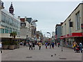
FY1 1UA is a small residential postcode area in England, home to 1,315 people. It is a compact cluster of properties, likely centred around local amenities and transport links. The area’s character is defined by its proximity to Blackpool’s urban infrastructure, with nearby attractions such as North Pier and Blackpool International Airport offering easy access to leisure and travel. Daily life here is shaped by its mix of retail, transport, and community hubs. With a population skewed toward adults aged 30–64, the area feels established rather than newly developed. Residents benefit from a network of five railway stations, including Blackpool North and South, which connect to broader regional routes. The presence of a primary school with a good Ofsted rating suggests a focus on family-oriented living. However, the area’s small size means it is tightly integrated with surrounding neighbourhoods, making it a convenient but limited space for those seeking a more expansive residential footprint.
- Area Type
- Postcode
- Area Size
- Not available
- Population
- 1315
- Population Density
- 4304 people/km²
The property market in FY1 1UA is characterised by a high proportion of flats and a low home ownership rate of 28%. This suggests that the area is more rental-focused than owner-occupied, likely attracting tenants rather than buyers seeking long-term investment. The prevalence of flats indicates a housing stock designed for efficiency, possibly in older buildings or purpose-built blocks. For buyers, this means limited opportunities for purchasing property, with competition likely centred on a small number of available homes. The area’s compact size further restricts the variety of properties available, making it essential for buyers to consider nearby regions for broader options. Those interested in homeownership may need to look beyond FY1 1UA to find larger homes or more traditional housing types.
House Prices in FY1 1UA
No properties found in this postcode.
Energy Efficiency in FY1 1UA
Life in FY1 1UA is shaped by its proximity to a range of amenities, including five metro stops such as North Pier and Talbot Road, which offer access to Blackpool’s attractions. Retail options are plentiful, with M&S Blackpool, Co-op Coastal, and Heron Talbot providing shopping and dining choices. The area’s rail network, with five stations, ensures easy travel to nearby towns, while Blackpool International Airport is within reach for those needing air travel. The presence of multiple railway stations and a central bus stop enhances mobility, though the area itself lacks large parks or recreational spaces. The mix of retail, transport, and leisure options suggests a practical, convenience-driven lifestyle, with residents relying on nearby hubs for more expansive facilities.
Amenities
Schools
The nearest school to FY1 1UA is Blackpool St John’s Church of England Primary School, which serves the local community with a good Ofsted rating. This primary school is a key asset for families, offering a reliable educational foundation for young children. The absence of secondary schools in the immediate area means that students may need to commute to nearby towns for further education, but the primary school’s quality reduces the pressure on parents seeking high-standard schooling. The single school listed reflects the area’s small size and limited educational infrastructure, which may be a consideration for families prioritising a range of school options.
| Rank | A + A* % | School | Type | Entry gender | Ages |
|---|---|---|---|---|---|
| 1 | N/A | Blackpool St John's Church of England Primary School | primary | N/A | N/A |
Explore more schools in this area
Go to Schools tabDemographics
The population of FY1 1UA is predominantly adults aged 30–64, with a median age of 47. This suggests a mature, settled community rather than a mix of younger families or retirees. Home ownership is relatively low at 28%, indicating that a significant proportion of residents are likely to be renting. The accommodation type is primarily flats, reflecting a housing stock suited to smaller households or those prioritising ease of maintenance. The predominant ethnic group is White, though no data on diversity or deprivation levels is provided. For those considering this area, the demographic profile implies a stable, low-turnover environment with a focus on practical living rather than rapid growth or development. The age range also suggests that local services and amenities cater to middle-aged residents, with schools and transport tailored to family needs.
Household Size
Accommodation Type
Tenure
Ethnic Group
Religion
Household Composition
Age
Household Deprivation
NS-SEC
Explore more demographic insights in this area
Go to Demographics tabPlanning
Planning Constraints
- Flood RiskLocked
- Ramsar Wetland SitesLocked
- Area of Outstanding Natural BeautyLocked
- Protected Nature ReserveLocked
- Protected WoodlandLocked
- Crime RiskLocked