Area Overview for Earby
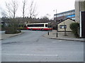
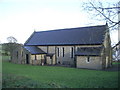
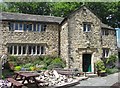
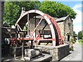
Photos of Earby

Area Information
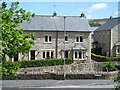
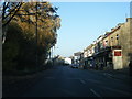
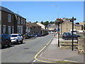
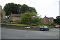
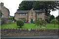
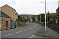
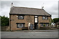
The town of Earby sits within Lancashire and covers an area of just 1.1 square kilometres. This compact built-up area creates a tightly knit community where you can move between amenities and your doorstep in minutes. The town has a median age of 70, meaning the population is predominantly composed of older residents rather than families. This age profile defines the character of daily life in Earby, which centres on quiet streets and a settled, long-term community presence. You will not find large commercial developments or significant youth hubs here. Instead, the town offers a traditional working-class atmosphere that has maintained its identity for generations. Homes in Earby attract those seeking stability and a low-key lifestyle rather than urban excitement. The small geographical size ensures that nothing is far away, making it ideal for those who value convenience and short commutes over expansive suburbs. Living in Earby means you share the space with a mature population, and the town functions as a local hub for the surrounding countryside. If you want a townscape that feels like a village within a larger council area, this location delivers on that specific promise without requiring you to travel for basic services.
- Area Type
- Built Up Area 250
- Area Size
- 1.1 km²
- Population
- Not available
- Population Density
- Not available
Residents of Earby have immediate access to essential retail needs without needing to travel further than the town centre. Within practical reach you will find five notable retail locations including Co-op Earby, Spar, and two additional Spar branches. These venues are sufficient for purchasing groceries, household supplies, and daily essentials. The presence of multiple supermarkets ensures that you can shop for fresh produce and household goods at varied price points. Rail transport connects Earby to larger hubs through four nearby stations: Colne Railway Station, Gargrave Railway Station, and Cononley Railway Station. While Earby itself does not list major railway stations, these nearby options provide regular train services connecting you to Burnley, Manchester, and Leeds. This rail access gives you the flexibility to visit the city for leisure or business if the occasion arises. You can also drive easily to these stations or rely on local bus networks managed by bus operators. Living in Earby offers a balance of quiet, rural living with convenient links to regional services.
Amenities
Schools
Your options for formal education within Earby itself are very limited due to the town's small size. The primary school options include Earby Springfield Primary School, which holds a satisfactory Ofsted rating. This school serves students from the immediate locality before they transfer to secondary education outside the town. There are no secondary schools listed within the built-up area of Earby in the provided data. Families must commute to neighbouring districts for older children's education. For parents planning to move to Earby, the school situation requires careful consideration of catchment areas beyond the town limits. Earby Springfield Primary School is the only institution with a recorded Ofsted rating in the immediate vicinity. The satisfactory rating indicates the school meets required standards without reaching higher performance brackets. You should research transport links to secondary schools in nearby towns like Burnley or Nelson, as these are the logical next steps for students. The availability of one primary school with a satisfactory rating does not offer the choice found in larger towns with multiple academies and specialist colleges.
| Rank | School | Type | Entry gender | Ages |
|---|
Explore more schools in this area
Go to Schools tabDemographics
You will encounter a community in Earby with almost no variation compared to other places in Manchester. The demographic data shows a median age of 70 years, which indicates that the majority of residents are seniors. There is no specific breakdown available for younger adults or children within the town limits. The population density is low because the total area of 1.1 square kilometres supports a mature resident base rather than a growing family cluster. Home ownership levels stand at 74%, which is a very high figure for the country as a whole. Possessing your own property is the norm rather than renting in this district. This high rate of ownership suggests financial stability among the local population and a strong attachment to the neighbourhood. Most households consist of older adults living in detached or semi-detached properties typical of the region. The accommodation types favour single-family dwellings over high-density flats or studio apartments. Regarding diversity and household composition, the available data records total figures without specifying unique ethnic groupings or religious affiliations. This lack of specific categorisation reflects the town's status as a smaller, traditional settlement. The community feels consistent and uniform rather than diverse or multicultural. You are buying into a scene where neighbours have known one another for many years. The static nature of the population means you are joining an established order rather than a shifting demographic landscape.
Household Size
Accommodation Type
Tenure
Ethnic Group
Religion
Household Composition
Age
Household Deprivation
NS-SEC
Explore more demographic insights in this area
Go to Demographics tabPlanning
Planning Constraints
- Crime RiskPremium