Area Overview for Droylsden
Photos of Droylsden


Area Information
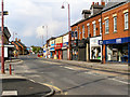
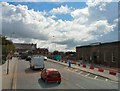
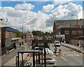
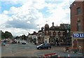
Droylsden is a built-up urban area situated in Greater Manchester with a total size of 3.8 square kilometres. Living in Droylsden involves navigating a compact residential landscape where daily life revolves around local transport hubs and immediate retail strips. The area functions as an established community rather than a developing fringe settlement, which shapes the rhythm of its daily existence. Visitors note that the town centre and surrounding streets form the primary nodes for commerce and movement. This density creates a neighbourhood where amenities are within walking distance for many, yet the character remains distinctly suburban in its housing stock. Prospective residents should view this location as a practical base for those working in nearby industrial zones or commuting via the regional rail network. The area does not offer the sprawling greenery of the countryside but provides the convenience of urban access. Residents of Droylsden interact with a mix of housing types that reflect the town's industrial history, creating a specific architectural identity. The compact nature of the 3.8 km² footprint means that the boundaries between residential zones and commercial hubs are clearly defined. Those considering homes in Droylsden will find a setting that prioritises accessibility over natural isolation.
- Area Type
- Built Up Area 250
- Area Size
- 3.8 km²
- Population
- Not available
- Population Density
- Not available
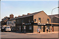
Residents of Droylsden benefit from a dense cluster of retail and transport amenities within immediate reach. Five major retail outlets are situated nearby, including Tesco Droylsden, Iceland Droylsden, and Spar. These stores provide essential daily shopping needs such as groceries and household items without the need for long drives. The variety of these chains indicates that the local high street meets the practical requirements of modern family life. Transport infrastructure supports this lifestyle with five metro stations located at key points like Droylsden, Cemetery Road, and Edge Lane. Five rail stations, including Fairfield Railway Station, Gorton Railway Station, and Guide Bridge Railway Station, further extend the reach of the area. While bus frequency is limited to one notable coach station at Chorlton Street, the rail network compensates significantly for connectivity needs. This combination of shops and transport hubs creates a functional neighbourhood where daily errands and commuting can be managed efficiently. Living in Droylsden offers convenience through proximity to these named venues and infrastructure points.
Amenities
Schools
Families located near Droylsden have several primary education options available to them within practical reach. Fairfield Road Primary School holds a Good rating from Ofsted, offering a recognised standard of education in the immediate vicinity. Nearby, Manchester Road Primary School and Moorside Primary School stand as other primary options for parents in the catchment area. Greenside Primary School is also listed as a local provision for younger children. Additionally, St Mary's CofE Primary School complements this list with its own Good Ofsted rating, ensuring two positively reviewed institutions are available to residents. Providing these schools near Droylsden offers parents a choice between state-supported education and faith-based Christian education. The presence of two schools with Good ratings suggests a baseline of quality in local primary provision. However, the absence of secondary schools in the immediate data list means that older children likely transfer to institutions outside this specific 3.8 km² area. For families, this configuration means the town centre and surrounding streets serve as the hub for younger children, while high school education is managed through the wider county system. Prospective buyers with school-age children should verify catchment boundaries for both primary and secondary institutions before committing to a purchase.
| Rank | School | Type | Entry gender | Ages |
|---|
Explore more schools in this area
Go to Schools tabDemographics
The community profile in Droylsden presents a distinct contrast to younger metropolitan hubs, with a median age of 70. Most residents fall into the total age demographic, suggesting a population significantly skewed towards older adults. This age profile indicates that the area may serve more as a retirement destination than a family-oriented district for younger generations. Homeownership stands at 63 per cent, which is a notable figure for a built-up area and suggests a population with established roots and financial security. Accommodation statistics further reflect this mature demographic, with the household composition aligning to the older age range. The high rate of home ownership implies that residents are less likely to be transient workers or students. Diversity within the predominant ethnic group and religious demographics completes the picture of a settled community. Living in Droylsden means entering an environment where neighbours have likely lived in their properties for decades. The social fabric is therefore built on long-term stability rather than the transient nature seen in developing cities. Families moving here should expect a quieter, slower-paced lifestyle compared to denser urban centres.
Household Size
Accommodation Type
Tenure
Ethnic Group
Religion
Household Composition
Age
Household Deprivation
NS-SEC
Explore more demographic insights in this area
Go to Demographics tabPlanning
Planning Constraints
- Crime RiskPremium