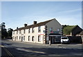
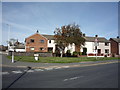
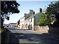
Area Overview for Dalston
Photos of Dalston


Area Information
Dalston is a built-up area in England covering 75.9 hectares, offering a compact yet distinct urban environment. With a median age of 70, the community here is predominantly older, shaping a unique social dynamic. The area’s proximity to rail networks and retail hubs makes it practical for daily life, while its size ensures a manageable footprint for residents. Dalston is not a sprawling suburb but a focused neighbourhood where amenities are within walking distance. The presence of two railway stations—Dalston and Carlisle—connects residents to broader transport networks, while nearby shops like Co-op Dalston and Spar provide essential services. Though small, the area balances convenience with a sense of locality, appealing to those seeking accessible living without the sprawl of larger towns. Its character is defined by a mix of older housing stock and community-focused infrastructure, reflecting a long-standing residential tradition. For buyers, Dalston offers a blend of practicality and a quiet, established presence in a well-connected part of England.
- Area Type
- Built Up Area 250
- Area Size
- 75.9 hectares
- Population
- Not available
- Population Density
- Not available
Daily life in Dalston is shaped by its compact layout and nearby amenities. The two railway stations—Dalston and Carlisle—offer easy access to regional travel, while local shops like Co-op Dalston and Spar provide essentials within walking distance. Though the area lacks detailed data on parks or leisure facilities, the presence of multiple retail outlets and rail links suggests a focus on convenience. The limited number of named amenities means the area may rely on nearby towns for broader leisure options, but for basic needs, residents have immediate access to shopping and transport. The character of Dalston is defined by its practicality, with a balance between local services and the need to travel further for more extensive facilities. This makes it suitable for those prioritising accessibility over expansive recreational spaces.
Amenities
Schools
Dalston is served by three schools, including St Michael’s CofE Primary School, which has an Ofsted rating of ‘good’, and Caldew School, which operates as both a primary school and an academy with a ‘good’ rating. These institutions provide a range of educational options for families, with the mix of school types offering flexibility. The presence of an academy suggests a focus on specialist education or broader curricula, while the primary schools cater to younger children. The ‘good’ Ofsted ratings indicate that both schools meet quality standards, though no further data on performance or student outcomes is available. For families prioritising education, Dalston’s schools offer a foundation, but the limited number of options means proximity to other schools may be a factor in decision-making.
| Rank | School | Type | Entry gender | Ages |
|---|
Explore more schools in this area
Go to Schools tabDemographics
The population of Dalston has a median age of 70, which is notably higher than the national average, indicating a community skewed towards older residents. Home ownership stands at 79%, suggesting a stable, long-term resident base rather than a transient population. The data does not specify household composition or accommodation types, but the high ownership rate implies many properties are owner-occupied rather than rented. The area’s demographics reflect a mature demographic profile, which may influence local services and amenities. While no specific data on deprivation or diversity is provided, the high median age and ownership rate suggest a community prioritising stability over rapid change. This profile may appeal to those seeking a quieter, established environment, though it also means the area is less likely to cater to younger families or transient populations.
Household Size
Accommodation Type
Tenure
Ethnic Group
Religion
Household Composition
Age
Household Deprivation
NS-SEC
Explore more demographic insights in this area
Go to Demographics tabPlanning
Planning Constraints
- Crime RiskPremium