Area Overview for CW7 2QT
Photos of CW7 2QT
Area Information
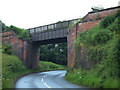
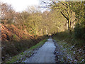
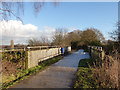
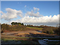
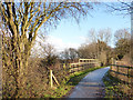
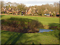
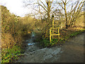
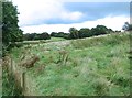
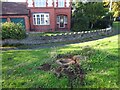
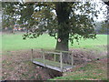
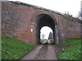
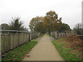
Living in CW7 2QT means being part of a small, tightly knit residential cluster in Cheshire, England. The area covers 4,123 square metres and is home to 1,953 people, giving it a low population density of 110 people per square kilometre. This makes it a quiet, low-traffic environment, ideal for those seeking a peaceful lifestyle. The postcode encompasses parts of Whitegate and Marton, historic settlements with roots tracing back to the 16th century. Key landmarks include St Mary’s Church, a listed building at the heart of Whitegate village, and the disused Whitegate railway line, now a footpath connecting nearby villages. The area’s charm lies in its blend of rural tranquillity and proximity to nearby towns like Winsford, offering access to amenities without sacrificing seclusion. With a median age of 47 and a strong home ownership rate, the community is mature and stable, making it a suitable choice for families or retirees seeking a slower pace of life.
- Area Type
- Postcode
- Area Size
- 4123 m²
- Population
- 1953
- Population Density
- 110 people/km²
The property market in CW7 2QT is characterised by high home ownership, with 90% of residents living in owner-occupied homes. This indicates a community that values long-term residency and stability, rather than a transient rental market. The predominant accommodation type is houses, which aligns with the area’s rural and semi-rural character. Given the small size of the postcode and its low population density, the housing stock is limited, making it a niche market for buyers seeking a quiet, low-density lifestyle. Those considering properties here should note that the immediate surroundings offer limited additional options, so buyers may need to look further afield for more choices. The focus on owner-occupied homes suggests a strong sense of community and investment in local property, which can be a positive sign for long-term value retention.
House Prices in CW7 2QT
Showing 2 properties
| Address | Type | Beds | Baths | Last Sale Price | Last Sale Date | |
|---|---|---|---|---|---|---|
| The Chestnuts, Whitegate Road, Winsford, CW7 2QT | Detached | 5 | 4 | £875,000 | Nov 2022 | |
| The Limes, Whitegate Road, Winsford, CW7 2QT | house | 5 | 4 | £389,995 | Jun 2001 |
Energy Efficiency in CW7 2QT
The lifestyle in CW7 2QT is shaped by its proximity to local amenities and historical sites. Nearby retail options include Morrisons Daily, Tesco Winsford, and Spar, providing essential shopping needs within practical reach. The area’s rail stations offer access to broader networks, enhancing connectivity for commuters. For leisure, the disused Whitegate railway line now functions as a footpath, offering scenic walking routes. The village’s listed buildings, such as St Mary’s Church, and nearby Vale Royal Abbey add cultural and historical interest. While the area lacks large-scale leisure facilities, its small-scale charm and quiet environment make it appealing for those valuing simplicity and a slower pace of life. The combination of local shops, transport links, and historical landmarks creates a balanced lifestyle, blending practicality with a touch of heritage.
Amenities
Schools
The nearest school to CW7 2QT is Whitegate CofE Primary School, which provides education for younger children. The school holds a ‘good’ Ofsted rating, indicating a satisfactory standard of teaching and facilities. As a primary school, it serves the immediate community but does not extend to secondary education, meaning families may need to consider nearby towns for secondary schooling. The absence of other schools in the area suggests that parents should plan for commuting to larger settlements like Winsford or Northwich for secondary-level education. Despite this, the presence of a well-rated primary school is a positive factor for families prioritising early education quality. The single school option reflects the small size of the area but also highlights the need for strategic planning when considering long-term family needs.
| Rank | School | Type | Entry gender | Ages |
|---|
Explore more schools in this area
Go to Schools tabDemographics
The population of CW7 2QT is predominantly adults aged 30–64, with a median age of 47. This suggests a community of established professionals, families, and retirees, rather than a younger demographic. Home ownership is high, with 90% of residents living in owner-occupied properties, and the majority of these are houses rather than flats. The predominant ethnic group is White, reflecting the area’s historical and cultural continuity. The low population density of 110 people per square kilometre indicates a spread-out, less crowded living environment. While no specific deprivation data is provided, the high home ownership rate and mature age profile suggest a relatively stable and self-sufficient community. The absence of detailed diversity statistics means the area’s social composition remains largely homogenous, which may appeal to those seeking familiarity and consistency in their local environment.
Household Size
Accommodation Type
Tenure
Ethnic Group
Religion
Household Composition
Age
Household Deprivation
NS-SEC
Explore more demographic insights in this area
Go to Demographics tabPlanning
Planning Constraints
- Flood RiskPremium
- Ramsar Wetland SitesPremium
- Area of Outstanding Natural BeautyPremium
- Protected Nature ReservePremium
- Protected WoodlandPremium