Area Overview for CW7 2PF
Photos of CW7 2PF
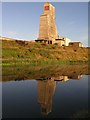
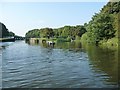
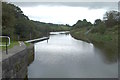
![Winsford Rock Salt Mine, from the River Weaver [1] in CW7 2PF](https://images.propbar.co.uk/images/geograph/51/64/5164212_120.jpg)
Area Information
Living in CW7 2PF means being part of a small, tightly knit residential cluster in Cheshire, England. The area spans 29.1 hectares and is home to 1,306 people, creating a compact community with a population density of 496 people per square kilometre. Situated in Moulton, a village 3 miles south of Northwich and 3 miles north of Winsford, this postcode benefits from its rural character while remaining within commuting distance of larger towns. The area’s history is rooted in 19th-century salt mining, which shaped its development into a commuter hub for nearby industries. Today, it blends traditional village life with modern amenities, including a primary school, local shops, and railway stations. The mix of older homes and post-war developments reflects its evolution from a working village to a family-oriented neighbourhood. With a median age of 47 and a strong presence of adults aged 30–64, the community is stable and mature, offering a quiet lifestyle with easy access to regional services.
- Area Type
- Postcode
- Area Size
- 29.1 hectares
- Population
- 1306
- Population Density
- 496 people/km²
The property market in CW7 2PF is characterised by a high rate of home ownership (66%) and a focus on houses rather than flats or apartments. This suggests a community where many residents are long-term homeowners, with properties likely to be family homes rather than investment properties. The small area size of 29.1 hectares means the housing stock is limited, which could lead to competition among buyers. Given the proximity to Northwich and Winsford, the area may attract commuters seeking a quieter, residential base while working in nearby towns. The predominance of houses over other property types indicates a preference for traditional, spacious living, which may appeal to families or those prioritising privacy. However, the limited scale of the area means buyers should consider the broader regional market for additional options.
House Prices in CW7 2PF
Showing 18 properties
| Address | Type | Beds | Baths | Last Sale Price | Last Sale Date | |
|---|---|---|---|---|---|---|
| 60, Vale Royal River Park, Bradford Road, Winsford, CW7 2PF | Mobile Home | - | - | - | - | |
| 38, Vale Royal River Park, Bradford Road, Winsford, CW7 2PF | Mobile Home | - | - | - | - | |
| Vale Royal River Park Caravan Site, Bradford Road, Winsford, CW7 2PF | Mobile Home | - | - | - | - | |
| 26, Vale Royal River Park, Bradford Road, Winsford, CW7 2PF | Mobile Home | - | - | - | - | |
| 71, Vale Royal River Park, Bradford Road, Winsford, CW7 2PF | Mobile Home | - | - | - | - | |
| 23, Vale Royal River Park, Bradford Road, Winsford, CW7 2PF | Mobile Home | - | - | - | - | |
| 64, Vale Royal River Park, Bradford Road, Winsford, CW7 2PF | Mobile Home | - | - | - | - | |
| Bridgefield, Bradford Road, Winsford, CW7 2PF | Equestrian | - | - | - | - | |
| 67, Vale Royal River Park, Bradford Road, Winsford, CW7 2PF | Mobile Home | - | - | - | - | |
| 42, Vale Royal River Park, Bradford Road, Winsford, CW7 2PF | Mobile Home | - | - | - | - |
Energy Efficiency in CW7 2PF
The lifestyle in CW7 2PF is shaped by its rural setting and proximity to essential amenities. Within practical reach are retail outlets such as Morrisons Daily, Co-op Winsford, and Morrisons Wharton, offering everyday shopping needs. The nearby railway stations—Winsford, Hartford, and Greenbank—provide access to regional transport, linking residents to cultural and employment hubs. The village itself hosts a local hall, which serves as a community hub for groups like the Moulton Drama Group, and a primary school that contributes to the area’s family-friendly atmosphere. While the data does not mention parks or leisure facilities explicitly, the historical character of Moulton, including landmarks like St Stephen’s Church and the Verdin Institute, suggests a blend of heritage and community activity. This balance of practical amenities and rural charm supports a lifestyle that is both convenient and rooted in tradition.
Amenities
Schools
The nearest school to CW7 2PF is Davenham CofE Primary School, which serves the local community with a primary education offering. The school holds a ‘good’ Ofsted rating, reflecting its quality of teaching and facilities. While no secondary schools are listed in the data, the presence of a primary school with a strong rating is a key consideration for families with young children. The school’s proximity to the area makes it a practical choice for parents, reducing the need for long commutes. However, residents seeking secondary education may need to look to nearby towns such as Northwich or Winsford, which likely host larger schools. The availability of a well-rated primary school contributes to the area’s appeal as a family-friendly location.
| Rank | School | Type | Entry gender | Ages |
|---|
Explore more schools in this area
Go to Schools tabDemographics
The population of CW7 2PF is 1,306, with a median age of 47 and a majority of residents aged 30–64. This suggests a community of established adults, many of whom may be in their prime working years or nearing retirement. Home ownership is high at 66%, indicating a strong presence of owner-occupied properties, which often correlates with long-term residency. The accommodation type is predominantly houses, reflecting a traditional, low-density housing stock. The predominant ethnic group is White, and while no specific data on diversity is provided, the demographic profile implies a relatively homogenous community. The population density of 496 people per square kilometre is moderate for a rural area, balancing privacy with proximity to amenities. This profile suggests a stable, family-oriented environment where residents are likely to have strong local ties and a shared sense of community.
Household Size
Accommodation Type
Tenure
Ethnic Group
Religion
Household Composition
Age
Household Deprivation
NS-SEC
Explore more demographic insights in this area
Go to Demographics tabPlanning
Planning Constraints
- Flood RiskPremium
- Ramsar Wetland SitesPremium
- Area of Outstanding Natural BeautyPremium
- Protected Nature ReservePremium
- Protected WoodlandPremium