Area Overview for CW7 2HW
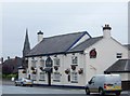
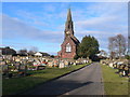
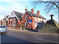
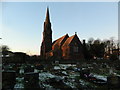
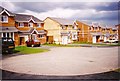
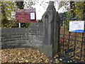
Photos of CW7 2HW
Area Information
Living in CW7 2HW means inhabiting a compact, densely populated residential cluster in Cheshire, England. This postcode area, spanning 4,522 square metres, is part of Winsford, a town with a population of around 35,500. Its high population density of 346,965 people per square kilometre reflects a tightly knit community. Winsford lies on the River Weaver, historically formed by the union of Over and Wharton townships in 1936. The area is close to Northwich and Middlewich, offering proximity to larger towns without sacrificing the charm of a smaller settlement. Daily life here is shaped by its medieval roots, with landmarks like St Chad’s Church and the town’s 1280 charter market still influencing its character. Residents benefit from a mix of local amenities, including retail outlets and railway stations, while the area’s low flood risk and moderate crime score suggest a balance of safety and practicality. CW7 2HW is ideal for those seeking a community with historical depth, practical infrastructure, and a compact, accessible layout.
- Area Type
- Postcode
- Area Size
- 4522 m²
- Population
- Not available
- Population Density
- Not available
The property market in CW7 2HW is characterised by a 37% home ownership rate, with houses being the predominant accommodation type. This suggests a mix of owner-occupied and rental properties, though the exact proportion of rentals is not specified. Given the area’s small size and high population density, housing stock is likely limited, with properties concentrated in a compact cluster. The prevalence of houses over flats indicates a focus on traditional, single-family homes, which may appeal to families seeking space and privacy. However, the small area size means buyers should consider proximity to nearby towns for additional options. The market’s dynamics are influenced by Winsford’s historical infrastructure and modern amenities, offering a blend of heritage and practicality. For buyers, this area may present opportunities for investment or long-term residency, though competition for properties could be fierce due to limited supply.
House Prices in CW7 2HW
Showing 17 properties
| Address | Type | Beds | Baths | Last Sale Price | Last Sale Date | |
|---|---|---|---|---|---|---|
| 31 Basford Way, Winsford, CW7 2HW | Flat | - | - | £64,995 | Aug 2020 | |
| 17 Basford Way, Winsford, CW7 2HW | Terraced | 3 | - | £102,500 | Dec 2016 | |
| 21 Basford Way, Winsford, CW7 2HW | house | - | - | £95,000 | Apr 2010 | |
| 11 Basford Way, Winsford, CW7 2HW | house | 3 | - | £42,500 | Jun 2000 | |
| 1 Basford Way, Winsford, CW7 2HW | Flat | 1 | 1 | - | - | |
| 23 Basford Way, Winsford, CW7 2HW | Terraced | - | - | - | - | |
| 3 Basford Way, Winsford, CW7 2HW | Flat | 3 | - | - | - | |
| 19 Basford Way, Winsford, CW7 2HW | house | - | - | - | - | |
| 7 Basford Way, Winsford, CW7 2HW | Flat | - | - | - | - | |
| 5 Basford Way, Winsford, CW7 2HW | Flat | - | - | - | - |
Energy Efficiency in CW7 2HW
Residents of CW7 2HW have access to a range of amenities within practical reach. Retail options include Morrisons Daily, Tesco Winsford, and Spar, providing convenience for daily shopping. The area’s railway stations—Winsford, Hartford, and Cuddington—facilitate travel to nearby towns and cities. While parks and leisure facilities are not explicitly listed in the data, the proximity to Winsford’s historical landmarks, such as St Chad’s Church and the 1280 charter market, suggests cultural and recreational opportunities. The compact layout of the area means amenities are closely clustered, reducing travel time. However, the absence of specific data on parks or leisure venues means their availability remains unquantified. The presence of retail and rail links, combined with the town’s historical character, creates a lifestyle that balances practicality with local heritage.
Amenities
Schools
The schools near CW7 2HW include Grange Community Primary School and Grange Community Nursery and Primary School, both of primary type. The latter holds an Ofsted rating of ‘good’, indicating a reliable standard of education. The presence of two primary schools within the area provides families with options for early education, though secondary schooling would require travel to nearby towns. This mix of schools suggests a focus on foundational education, with the ‘good’-rated school offering a benchmark for quality. Families prioritising primary education may find the local options sufficient, but those requiring secondary schooling should consider proximity to larger educational hubs. The schools’ availability supports the area’s appeal to families, though the absence of specific data on student outcomes or facilities limits further analysis.
| Rank | School | Type | Entry gender | Ages |
|---|
Explore more schools in this area
Go to Schools tabDemographics
The community in CW7 2HW is predominantly composed of adults aged 30–64, with a median age of 47. This suggests a mature population, likely with established careers and families. Home ownership stands at 37%, indicating a mix of owner-occupied and rental properties. The area’s accommodation is primarily houses, reflecting a preference for single-family dwellings over flats. The predominant ethnic group is White, aligning with broader demographic trends in the region. With a population of 1,569, the area is small but densely populated, which may influence social dynamics and local services. The lack of specific deprivation data means quality of life factors like access to healthcare or leisure remain unquantified. However, the presence of schools and retail amenities suggests a baseline of convenience. The demographic profile indicates a stable, family-oriented environment, though the high population density may impact personal space and community interaction.
Household Size
Accommodation Type
Tenure
Ethnic Group
Religion
Household Composition
Age
Household Deprivation
NS-SEC
Explore more demographic insights in this area
Go to Demographics tabPlanning
Planning Constraints
- Flood RiskPremium
- Ramsar Wetland SitesPremium
- Area of Outstanding Natural BeautyPremium
- Protected Nature ReservePremium
- Protected WoodlandPremium