Area Overview for CW6 9FR
Photos of CW6 9FR


Area Information
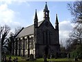
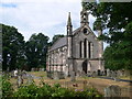
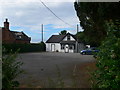
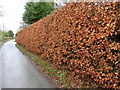
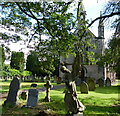
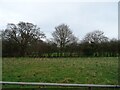
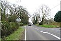
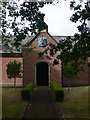
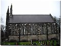
CW6 9FR is a small, rural postcode area in Cheshire, England, encompassing parts of the civil parish of Tiverton and Tilstone Fearnall. With a population of 2,168 spread across 208 dwellings, it has a low density of 63 people per square kilometre, reflecting its quiet, village-like character. The area blends traditional and modern elements, with 1960s developments coexisting alongside historic properties and listed buildings such as Brassey Green Baptist Chapel and St Jude’s Church. Residents enjoy proximity to the Shropshire Union Canal and River Gowy, which form part of the southern boundary, and 28km of footpaths, including the Sandstone Trail, offering rural walks and solitude. The village centre revolves around the Methodist Chapel, Village Hall, and a public house with a restaurant and campsite, complemented by an Indian restaurant on the parish boundary. While some traditional services like the post office and primary school have declined, the area retains a close-knit community feel. Its location, two miles south of Tarporley, provides access to nearby amenities without compromising the tranquillity of rural life.
- Area Type
- Postcode
- Area Size
- Not available
- Population
- 2168
- Population Density
- 63 people/km²
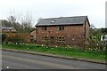
The property market in CW6 9FR is characterised by a high rate of home ownership (76%) and a predominance of houses over flats or other accommodation types. This indicates a stable, owner-occupied market with limited rental activity, which is typical of rural areas with low population density. The housing stock blends older properties, including listed buildings and 1960s developments, with newer extensions. Buyers in this small area should expect a limited inventory of homes, as the postcode covers only 208 dwellings. The market is likely to cater to those seeking a quieter, rural lifestyle, with properties often featuring larger plots and proximity to natural features like the River Gowy. However, the small size of the area means that buyers may need to look beyond CW6 9FR to Tarporley or surrounding villages for more extensive property options.
House Prices in CW6 9FR
No properties found in this postcode.
Energy Efficiency in CW6 9FR
Living in CW6 9FR offers a blend of rural tranquillity and small-town amenities. The nearest shops include Spar, Co-op Bunbury, and Co-op Tarporley, providing essentials within a short drive. The village centre features a public house with a restaurant and campsite, an Indian restaurant on the parish boundary, and the Methodist Chapel and Village Hall, which host community events. The area’s natural assets, such as the Shropshire Union Canal and River Gowy, offer opportunities for walking, cycling, and outdoor recreation. With 40 footpaths spanning 28km, including the Sandstone Trail, residents can enjoy scenic routes and solitude. While the loss of a post office and primary school has shifted the village’s focus, the remaining amenities support a self-sufficient lifestyle, appealing to those seeking a peaceful, low-density environment.
Amenities
Schools
| Rank | School | Type | Entry gender | Ages |
|---|
Explore more schools in this area
Go to Schools tabDemographics
The population of CW6 9FR has a median age of 47, with the majority of residents aged 30–64. This suggests a mature, stable community with a strong presence of middle-aged households. Home ownership is high at 76%, indicating a predominance of owner-occupied properties rather than rentals. The accommodation type is primarily houses, reflecting a residential area with limited high-density housing. The predominant ethnic group is White, though no specific data on diversity or deprivation is provided. The age profile and ownership rates suggest a community focused on long-term residency, with fewer transient populations. The absence of significant youth or elderly demographics may influence local services and amenities, aligning with the area’s low population density and rural character.
Household Size
Accommodation Type
Tenure
Ethnic Group
Religion
Household Composition
Age
Household Deprivation
NS-SEC
Explore more demographic insights in this area
Go to Demographics tabPlanning
Planning Constraints
- Flood RiskPremium
- Ramsar Wetland SitesPremium
- Area of Outstanding Natural BeautyPremium
- Protected Nature ReservePremium
- Protected WoodlandPremium