Area Overview for CW5 5BP
Photos of CW5 5BP

Area Information
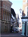
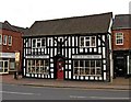
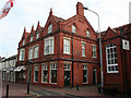
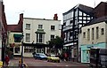
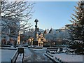
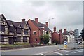
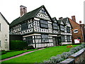
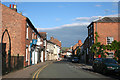
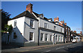
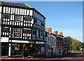
Living in CW5 5BP means being part of a small, tightly knit residential cluster in Cheshire, England. With a population of just 1,652, this postcode area reflects the quiet charm of a historic market town. Nantwich, the nearby town, has roots in Roman salt production, earning it the Welsh name *Hellath Wen* — "town of white salt." The area’s character is shaped by its proximity to Nantwich’s medieval landmarks, including St Mary’s Church and timber-framed buildings that survived the Great Fire of 1583. Residents benefit from nearby railway stations, including Nantwich and Crewe, which connect to major cities like Manchester and Chester. Daily life here balances historic appeal with modern convenience, though the small population means community ties are strong. The area’s compact size ensures a slower pace of life, with local amenities and green spaces accessible within short distances. For those seeking a mix of heritage and practicality, CW5 5BP offers a distinctive blend of tradition and connectivity.
- Area Type
- Postcode
- Area Size
- Not available
- Population
- 1652
- Population Density
- 3180 people/km²
The property market in CW5 5BP is characterised by a strong emphasis on home ownership, with 62% of residents owning their homes. The area is predominantly composed of houses, which are the primary accommodation type. This suggests a market skewed towards owner-occupied properties rather than rentals, offering buyers a range of established homes. Given the small population and compact nature of the postcode area, the housing stock is limited, meaning opportunities for new builds or developments are likely constrained. Buyers should consider the area’s proximity to Nantwich and its historic character, which may influence property values and desirability. The focus on houses also implies a preference for private, family-oriented living, which could appeal to those seeking a traditional, low-density environment.
House Prices in CW5 5BP
No properties found in this postcode.
Energy Efficiency in CW5 5BP
Residents of CW5 5BP have access to a range of local amenities within practical reach. The retail sector includes notable stores such as Morrisons, Aldi, and M&S in Nantwich, providing essential shopping and dining options. Nearby railway stations — Nantwich, Crewe, and Wrenbury — offer convenient transport links to larger towns and cities, enhancing connectivity for commuters and visitors. While the area’s historical character is evident in its timber-framed buildings and medieval landmarks, the data does not specify parks or leisure facilities. Nonetheless, the presence of retail and transport hubs suggests a lifestyle that balances heritage with modern convenience. The compact size of the postcode area ensures that daily errands and social activities are within short distances, fostering a sense of community.
Amenities
Schools
| Rank | School | Type | Entry gender | Ages |
|---|
Explore more schools in this area
Go to Schools tabDemographics
The community in CW5 5BP is predominantly composed of adults aged 30–64, with a median age of 47. This suggests a mature, settled population, likely with established careers and family ties. Home ownership rates are high at 62%, indicating a stable, owner-occupied demographic. The accommodation type is primarily houses, reflecting a preference for single-family homes over flats or apartments. The predominant ethnic group is White, aligning with broader regional trends. While specific data on deprivation is absent, the high home ownership and age profile suggest a relatively affluent, low-turnover community. However, the lack of detailed diversity statistics means the full range of cultural or socioeconomic factors influencing daily life remains unexplored.
Household Size
Accommodation Type
Tenure
Ethnic Group
Religion
Household Composition
Age
Household Deprivation
NS-SEC
Explore more demographic insights in this area
Go to Demographics tabPlanning
Planning Constraints
- Flood RiskPremium
- Ramsar Wetland SitesPremium
- Area of Outstanding Natural BeautyPremium
- Protected Nature ReservePremium
- Protected WoodlandPremium