Area Overview for CW4 7BB
Photos of CW4 7BB

Area Information
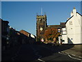
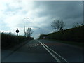
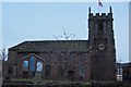
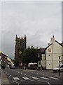
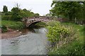
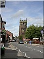
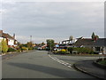
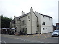
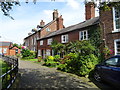
Living in CW4 7BB, a small residential postcode cluster in Cheshire, England, means being part of a tightly knit community with a rich historical backdrop. The area covers 2,225 square metres and is home to 1,739 residents, resulting in a high population density of 781,678 people per square kilometre. Situated approximately 8 miles north of Crewe and 21 miles south of Manchester, CW4 7BB lies within the village of Holmes Chapel, a historic settlement that developed around a crossroads on the London-to-Lancashire route. The area’s charm is rooted in its heritage, including St Luke’s Church, a Grade I listed building dating to the 1430s, and the Old Red Lion inn, which once hosted John Wesley in 1738. Daily life here is shaped by a mix of rural tranquillity and proximity to urban centres, with residents benefiting from nearby railway stations and a cluster of local amenities. The area’s compact size and historical significance make it distinctive, offering a blend of traditional architecture and modern convenience.
- Area Type
- Postcode
- Area Size
- 2225 m²
- Population
- 1739
- Population Density
- 2852 people/km²
The property market in CW4 7BB is characterised by a high rate of home ownership (71%) and a predominance of houses, indicating a residential area with limited rental activity. This suggests a community of long-term residents rather than a transient population. The small size of the postcode area means housing stock is concentrated, with properties likely to be family homes or semi-detached houses. Buyers should consider that the area’s compact nature may limit availability of new builds or larger properties. The high home ownership rate also implies strong local demand, which could influence property values. For those seeking a stable, family-friendly environment with established housing, CW4 7BB offers a mix of traditional homes in a historic setting, though the limited size of the area may require buyers to look beyond immediate surroundings for more options.
House Prices in CW4 7BB
No properties found in this postcode.
Energy Efficiency in CW4 7BB
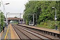
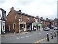
Residents of CW4 7BB have access to a range of nearby amenities, including five retail outlets such as Morrisons Daily Holmes, Tesco Holmes, and Sainsburys Holmes Chapel. These shops provide everyday convenience, from groceries to household essentials. The area’s rail network, with stations like Holmes Chapel and Goostrey, offers easy access to nearby towns and cities, enhancing mobility for commuters and shoppers. While the data does not list parks or leisure facilities explicitly, the historical character of the area, including The Square and St Luke’s Church, suggests opportunities for social and cultural engagement. The compact size of the postcode means amenities are within practical reach, supporting a lifestyle that balances local convenience with proximity to larger urban centres.
Amenities
Schools
The nearest school to CW4 7BB is Holmes Chapel Primary School, a primary school with an Ofsted rating of ‘good’. This institution serves the local community, providing education for younger children in the area. The presence of a primary school with a positive rating is a key consideration for families, ensuring access to quality early education. However, the data does not include secondary schools or further education institutions, so families may need to look to nearby towns for secondary schooling. The single primary school available suggests a focus on local education, which can foster a close-knit school community. Parents should verify the catchment areas and transportation options for older children, as the data does not specify further educational facilities.
| Rank | School | Type | Entry gender | Ages |
|---|
Explore more schools in this area
Go to Schools tabDemographics
The community in CW4 7BB is predominantly composed of adults aged 30–64, with a median age of 47. This suggests a mature population, likely with established careers and family ties to the area. Home ownership is high at 71%, indicating a stable, long-term resident base. The accommodation type is primarily houses, reflecting a residential character rather than high-density housing. The predominant ethnic group is White, which aligns with broader demographic trends in rural Cheshire. The high home ownership rate and age profile suggest a community focused on stability and long-term living, with fewer transient residents. The absence of specific data on deprivation or diversity means the area’s social dynamics are not fully detailed, but the demographic profile points to a cohesive, family-oriented environment.
Household Size
Accommodation Type
Tenure
Ethnic Group
Religion
Household Composition
Age
Household Deprivation
NS-SEC
Explore more demographic insights in this area
Go to Demographics tabPlanning
Planning Constraints
- Flood RiskPremium
- Ramsar Wetland SitesPremium
- Area of Outstanding Natural BeautyPremium
- Protected Nature ReservePremium
- Protected WoodlandPremium