Area Overview for CW2 5LF
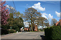
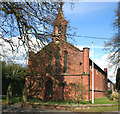
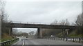
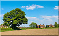
Photos of CW2 5LF

Area Information
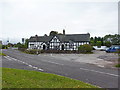
Living in the CW2 5LF postcode area means settling into a specific residential cluster that spans just 2.9 hectares. This compact footprint houses 1,023 people, creating a tightly knit neighbourhood within the broader civil parish of Weston and Crewe Green. You are situated in Cheshire East, a region in North West England, where this village formed in 2023 after merging Weston, Basford, and Crewe Green. The area includes historic settlements like Weston Village, Basford, and the village of Crewe Green, which lies 1.5 miles east of Crewe town centre. Daily life here is defined by proximity to local landmarks such as Crewe Hall, a Jacobean mansion built between 1615 and 1636. The community encompasses a mix of listed 17th-century timber-framed buildings, estate cottages, and farms, particularly at Stowford. You will find yourself in an environment shaped by centuries of history, from the de Crewe family's estate in the 12th century to its use as a POW barracks during the Second World War. The parish is administered by Weston and Crewe Green Parish Council, ensuring local governance remains close to residents. For buyers seeking a residential zone with deep historical roots rather than modern sprawl, CW2 5LF offers a defined cluster where the past remains visible in the architecture.
- Area Type
- Postcode
- Area Size
- 2.9 hectares
- Population
- 1023
- Population Density
- 176 people/km²
The housing stock in CW2 5LF is overwhelmingly dominated by owner-occupied homes. As 79% of residents are homeowners, the area functions as a traditional market where purchase is the norm rather than renting. Houses make up the main accommodation type, fitting the description of the civil parish which includes villages like Weston and Crewe Green. This high ownership level means the local market consists primarily of people looking to buy properties within this specific 2.9-hectare cluster or the immediate wider parish. When you look for homes in CW2 5LF, you should expect a market driven by established residents who have likely been living there for decades or generations. The property inventory will not feature a large concentration of private landlords or short-term lets. Instead, the homes are typically family dwellings or retirement properties, reflecting the median age of 47 for the population. The predominance of houses over flats or terraced blocks aligns with the area's historic character, featuring listed timber-framed buildings and estate cottages. For buyers, this stability means fewer property turnover issues and a market where neighbours are likely to be your neighbours for a long time. The low population density of 176 people per square kilometre further supports the idea of spacious, detached or semi-detached living rather than urban density.
House Prices in CW2 5LF
Showing 11 properties
| Address | Type | Beds | Baths | Last Sale Price | Last Sale Date | |
|---|---|---|---|---|---|---|
| 46 Main Road, Weston, CW2 5LF | Terraced | 2 | 1 | £207,500 | May 2025 | |
| 44 Main Road, Weston, CW2 5LF | Terraced | 3 | 1 | £180,000 | Jun 2024 | |
| 41 Main Road, Weston, CW2 5LF | Detached | 3 | 2 | £250,000 | Jan 2019 | |
| 48 Main Road, Weston, CW2 5LF | house | - | - | £119,000 | Jun 2005 | |
| 33 Main Road, Weston, CW2 5LF | Detached | - | - | £317,000 | Jan 1998 | |
| The Cottage, 40 Main Road, Weston, CW2 5LF | Cottage | 3 | 1 | - | - | |
| 42 Main Road, Weston, CW2 5LF | Flat | - | - | - | - | |
| 43 Main Road, Weston, CW2 5LF | house | 3 | 2 | - | - | |
| 58 Main Road, Weston, CW2 5LF | house | - | - | - | - | |
| 50 Main Road, Weston, CW2 5LF | Terraced | 2 | 2 | - | - |
Energy Efficiency in CW2 5LF
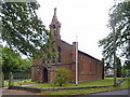
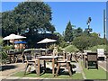
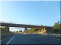
Living in CW2 5LF places you just minutes from a range of essential amenities that support daily life comfortably. Five retail venues are within practical reach, including Asda Crewe Bastford, Aldi University, and Co-op Gateway. These supermarkets and shops provide immediate access to groceries and household necessities without requiring long journeys. For commuters, four railway stations are nearby, facilitating easy travel to Crewe, Alsager, Nantwich, and beyond. The local area is rich in history and landmarks, such as Crewe Hall and the Church of St Michael and All Angels. You can enjoy walks around historic sites or visit the Victorian school house in Crewe Green. The parish includes noted features like farms at Stowford, offering a glimpse into rural life alongside modern convenience. This blend of historic charm and accessible retail means you do not need to travel far for essentials or leisure. The area combines the quiet of a village with the practicality of being close to larger towns. Retail and transport infrastructure ensures that the small size of the postcode does not limit your daily choices.
Amenities
Schools
Families in CW2 5LF benefit from access to Weston Village Primary School, which is situated within the local neighbourhood. This primary school holds a "good" Ofsted rating, confirming its standard of education. As a single entry in the local school listings, this institution represents the only named educational facility in the immediate data set for this postcode. The presence of a rated primary school means that young children in the area are educated locally before potentially transferring to secondary schools outside the immediate vicinity. Weston Village Primary School serves the immediate needs of families who live in the 1,023-person cluster. Living in CW2 5LF offers the advantage of keeping your young children close to home while attending a school that has been officially assessed as good. This setup reduces commute times for parents and allows for a routine centered around the local community. For buyers prioritising educational convenience, the proximity to this specifically rated primary institution is a key feature. The school's "good" status provides a baseline of quality assurance for families considering the area for their children's upbringing.
| Rank | School | Type | Entry gender | Ages |
|---|
Explore more schools in this area
Go to Schools tabDemographics
The population of CW2 5LF skews noticeably older than the national average, with a median age of 47. The majority of residents fall into the adult category spanning 30 to 64 years, suggesting a community anchored by established families or individuals in their prime working years. Home ownership stands at a striking 79%, indicating that most people in this postcode have purchased their homes rather than renting. This high rate of ownership creates a stable environment where residents have a long-term stake in the locality. Houses remain the predominant accommodation type, reflecting a traditional village character rather than high-density living. The demographic profile is predominantly White, which aligns with the broader composition of Cheshire East. With a population density of 176 people per square kilometre, the area maintains a low-to-medium density feel despite its small 2.9-hectare size. You are not dealing with a transient rental market or a hub of students and seasonal workers; instead, the community consists of long-term residents who have built their lives around this specific cluster. The age and ownership data suggest a neighbourhood where decisions about property maintenance and development are made by settled homeowners.
Household Size
Accommodation Type
Tenure
Ethnic Group
Religion
Household Composition
Age
Household Deprivation
NS-SEC
Explore more demographic insights in this area
Go to Demographics tabPlanning
Planning Constraints
- Flood RiskPremium
- Ramsar Wetland SitesPremium
- Area of Outstanding Natural BeautyPremium
- Protected Nature ReservePremium
- Protected WoodlandPremium