Area Overview for CW12 1UN
Photos of CW12 1UN
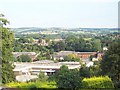


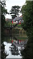
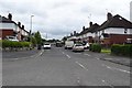
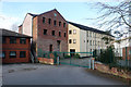


56 photos from this area
Area Information
Key information about the CW12 1UN including its size, population, and administrative classification.
- Area Type
- Postcode
- Area Size
- 2.9 hectares
- Population
- 2436
- Population Density
- 2794 people/km²
House Prices in CW12 1UN
8
Properties
-
Average Sold Price
-
Lowest Price
-
Highest Price
Showing 8 properties
| Address | Type | Beds | Baths | Last Sale Price | Last Sale Date | |
|---|---|---|---|---|---|---|
| Vet Tech Solutions Limited, Unit 15 And 17, Daneside Business Park, Riverdane Road, Congleton, CW12 1UN | warehouse | - | - | - | - | |
| Unit 18A, Daneside Business Park, Riverdane Road, Congleton, CW12 1UN | Industrial | - | - | - | - | |
| Congleton Propshafts, Daneside Business Park, Riverdane Road, Congleton, CW12 1UN | Industrial | - | - | - | - | |
| Unit 13, Daneside Business Park, Riverdane Road, Congleton, CW12 1UN | office_workshop | - | - | - | - | |
| Congleton Engineering Development Ltd, Daneside Business Park, Riverdane Road, Congleton, CW12 1UN | Industrial | - | - | - | - | |
| Navboys Ltd, Unit 4, Daneside Business Park, Riverdane Road, Congleton, CW12 1UN | storage_distribution | - | - | - | - | |
| Unit 12, Daneside Business Park, Riverdane Road, Congleton, CW12 1UN | storage_distribution | - | - | - | - | |
| Daneside House, Daneside Business Park, Riverdane Road, Congleton, CW12 1UN | office_workshop | - | - | - | - |
Energy Efficiency in CW12 1UN
Amenities
Schools
| Rank | School | Type | Entry gender | Ages |
|---|
Explore more schools in this area
Go to Schools tabDemographics
Household Size
Two person
most common
Accommodation Type
Houses
most common
Tenure
86
majority
Ethnic Group
White
most common
Religion
N/A
most common
Household Composition
N/A
most common
Age
47
median
Adults (30-64 years)
most common
Household Deprivation
N/A
with no deprivation
NS-SEC
43
in Lower managerial occupations
Explore more demographic insights in this area
Go to Demographics tabPlanning
Planning Constraints
- Flood RiskPremium
- Ramsar Wetland SitesPremium
- Area of Outstanding Natural BeautyPremium
- Protected Nature ReservePremium
- Protected WoodlandPremium