Area Overview for CW11 4BE
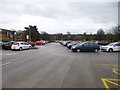
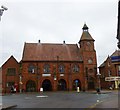
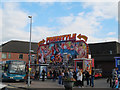
Photos of CW11 4BE

Area Information
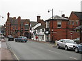
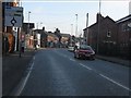
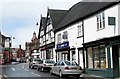
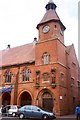
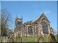
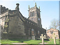
Living in CW11 4BE means being part of a compact, densely populated residential cluster in the heart of Sandbach, a historic market town in Cheshire East. The area covers just 7,414 square metres, yet supports 1,455 residents, creating a tight-knit community with a population density of 196,241 people per square kilometre. Sandbach itself has roots in the Domesday Book, with a market charter granted in 1579 that shaped its economic and social fabric. Today, the area blends historical charm with modern convenience. Residents benefit from proximity to the Thursday market, which has operated since the 16th century, and a network of rail stations connecting to nearby towns. The small size of the postcode means a strong sense of local identity, with amenities like Waitrose, Morrisons, and Sandbach Railway Station within walking distance. For those seeking a mix of heritage and practicality, CW11 4BE offers a distinctive blend of compact living and accessible services.
- Area Type
- Postcode
- Area Size
- 7414 m²
- Population
- 1455
- Population Density
- 2611 people/km²
The property market in CW11 4BE is characterised by a 51% home ownership rate, with houses forming the predominant accommodation type. This suggests a mix of owner-occupied and rental properties, though the small area size means the housing stock is limited. The presence of houses, rather than flats or apartments, indicates a traditional, low-density residential pattern typical of historic market towns. For buyers, this means a focus on individual homes rather than high-rise or shared housing. The compact nature of the postcode means properties are likely to be in close proximity to local amenities, such as Sandbach’s market and rail links. However, the small size of the area may limit availability, requiring buyers to consider nearby postcodes for more options. The market is likely to appeal to those prioritising stability and proximity to services over expansive living spaces.
House Prices in CW11 4BE
No properties found in this postcode.
Energy Efficiency in CW11 4BE
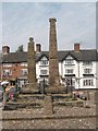
The lifestyle in CW11 4BE is shaped by its proximity to Sandbach’s historic town centre, where shops, bars, and the Thursday market create a vibrant retail and social environment. Nearby retail options include Waitrose Sandbach, Iceland Sandbach, and Morrisons Daily, offering a range of grocery and convenience services. The area’s rail links to Sandbach, Holmes Chapel, and Alsager provide easy access to broader leisure and employment opportunities. The Thursday market, established in 1579, remains a focal point for local commerce, while the town’s heritage—such as the Anglo-Saxon Sandbach Crosses—adds cultural depth. For residents, the blend of traditional market charm and modern amenities creates a convenient, characterful lifestyle with minimal need to travel beyond the immediate vicinity.
Amenities
Schools
Residents of CW11 4BE have access to two primary schools: Sandbach Community Primary School and Sandbach Primary Academy. Both institutions serve the local population, though Sandbach Primary Academy holds a ‘good’ Ofsted rating, reflecting its quality of education. The presence of two primary schools within the area provides families with options, though the small postcode size means catchment areas may be limited. For parents, the availability of a rated school adds value to the area, though the absence of secondary schools necessitates travel to nearby towns. The mix of school types—both primary—suggests a focus on early education, with no data on secondary provision. This makes CW11 4BE particularly suited to families with young children, though older students may require additional planning for schooling.
| Rank | School | Type | Entry gender | Ages |
|---|
Explore more schools in this area
Go to Schools tabDemographics
The community in CW11 4BE is predominantly composed of adults aged 30–64, with a median age of 47. This suggests a mature population, likely with established careers and family ties to the area. Home ownership stands at 51%, indicating a balance between owner-occupied properties and rental units. The accommodation type is primarily houses, reflecting a residential character shaped by traditional housing stock. The predominant ethnic group is White, aligning with broader trends in the region. The high population density—196,241 people per square kilometre—means the area is intensely populated, which can influence local dynamics such as school catchment sizes and community engagement. While no specific deprivation data is provided, the demographic profile suggests a stable, middle-aged population with a focus on long-term residency.
Household Size
Accommodation Type
Tenure
Ethnic Group
Religion
Household Composition
Age
Household Deprivation
NS-SEC
Explore more demographic insights in this area
Go to Demographics tabPlanning
Planning Constraints
- Flood RiskPremium
- Ramsar Wetland SitesPremium
- Area of Outstanding Natural BeautyPremium
- Protected Nature ReservePremium
- Protected WoodlandPremium